Taum Sauk Mountain State Park
Community Reviews
Been here? Share the conditions.
Reviews, ratings & photos are added in the free Snoflo iOS app — rate a spot, tag the conditions, and your visit is verified by location. Add or manage your reviews from the app.
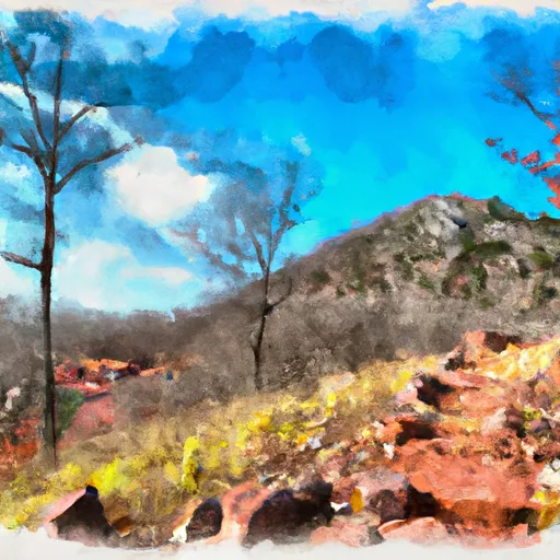
Taum Sauk Mountain State Park
Nestled within the St. Francois Mountains, Taum Sauk Mountain State Park is a haven for nature enthusiasts and outdoor adventurers alike. Here are some compelling reasons to visit this park:
1. Magnificent Mountain Peak: The park is home to Taum Sauk Mountain, the highest peak in Missouri, reaching an elevation of 1,772 feet. Hiking to the summit rewards visitors with stunning panoramic views of the surrounding Ozark landscape.
2. Mina Sauk Falls: This state park boasts Mina Sauk Falls, Missouri's highest waterfall. The falls cascade 132 feet down a rocky slope, creating a picturesque and serene setting. It is a must-see attraction for nature lovers and photographers.
3. Hiking Trails: With over 15 miles of trails, Taum Sauk Mountain State Park offers opportunities for hikers of all levels. The Ozark Trail, stretching over 230 miles, passes through the park and provides access to scenic overlooks, stunning rock formations, and diverse flora and fauna.
4. Wilderness Camping: The park offers primitive camping sites nestled within the wilderness, allowing visitors to immerse themselves in nature. These secluded areas provide a peaceful retreat, perfect for stargazing and enjoying the tranquility of the outdoors.
5. Unique Geological Features: Taum Sauk Mountain State Park showcases the region's unique geological formations, including exposed granite and volcanic rocks. These formations provide opportunities for exploration and add to the park's scenic allure.
Interesting facts about Taum Sauk Mountain State Park:
- The park was established in 1991 and encompasses approximately 7,448 acres.
- It is named after the Taum Sauk Mountain, which is believed to have received its name from the Native American Osage tribe.
- The park is part of the Ozark Trail system, a multi-state trail that meanders through the Ozark Mountains, providing extensive opportunities for outdoor recreation.
The best time to visit Taum Sauk Mountain State Park is during the spring and fall seasons. In spring, the park comes alive with blooming wildflowers, and the moderate temperatures are ideal for hiking. Fall offers vibrant foliage, transforming the park into a picturesque landscape. Summers can be hot and humid, while winters can be cold and snowy, limiting certain activities.
Remember to consult official sources for the most up-to-date information on fees, operating hours, and any potential restrictions or closures before planning your visit to Taum Sauk Mountain State Park.
Trails in Taum Sauk Mountain State Park
Named trails whose route falls inside the park.
Points of interest in Taum Sauk Mountain State Park
Landmarks and points of interest inside the park boundary.

Plan your visit down to the hour
Same weather feed Snoflo's iOS app uses -- updated continuously from NOAA / yr.no.
Next 5 days, hour by hour
Temperature line with weather symbols on top, snow + rain accumulation as columns, humidity as a dotted line.
5-day forecast table
Every 3 hours, broken out across temperature, snow, rain, humidity, and wind.
| Time | Condition | Temp (°F) | Snow (in) | Rain (in) | Humidity (%) | Wind (mps) | Wind dir |
|---|---|---|---|---|---|---|---|
| Loading detailed forecast… | |||||||
15-day temperature & precipitation
Daily temperatures, snow, and rain projected over the next two weeks.
Responsible recreation & Leave No Trace
- Know before you go
- Check the operator's site for hours, permit requirements, seasonal closures, and fire restrictions before heading out.
- Stay on trail
- Stick to marked paths to protect vegetation, prevent erosion, and avoid disturbing wildlife habitat.
- Respect wildlife
- Observe from a distance, never feed wildlife, and store food securely if camping is permitted on-site.
- Pack it in, pack it out
- Carry out all trash, food scraps, and gear. Many parks have limited or no trash service.
- Leave what you find
- Don't take rocks, plants, or artifacts. They make the park what it is for the next visitor.
Set push alerts in the Snoflo app
Save Taum Sauk Mountain State Park as a favorite, set a custom threshold (precipitation, freezing temperatures, fire-restriction days), and the iOS app will push the moment conditions cross.
About Taum Sauk Mountain State Park
What can I do at Taum Sauk Mountain State Park?
Most Snoflo-tracked parks support hiking, picnicking, and wildlife viewing. Check the operator's site for activity-specific rules (camping, fishing, paddling, hunting).
How fresh is the weather data?
The hourly forecast updates throughout the day from NOAA / yr.no. Streamflow comes live from USGS streamgauges.
When is the best time to visit?
Use the 15-day temperature & precipitation outlook on this page to plan -- pick a window with comfortable temperatures and low precipitation.
How do I get to Taum Sauk Mountain State Park?
Tap Directions in the hero above to open driving directions in Google Maps, or Open in map to center the Snoflo interactive map on the park.
Can I get alerts when conditions change?
Yes -- alerts are managed in the Snoflo iOS app. Favorite this park, set a threshold (temperature, precipitation), and you'll get a push the moment it crosses.
Park & land designation reference
A quick legend for the federal and state land categories Snoflo tracks. Each designation comes with different rules around access, recreation, and resource extraction.
- National Park
- Large protected natural areas managed by the federal government to preserve significant landscapes, ecosystems, and cultural resources; recreation is allowed but conservation is the priority.
- State Park
- Public natural or recreational areas managed by a state government, typically smaller than national parks and focused on regional natural features, recreation, and education.
- Local Park
- Community-level parks managed by cities or counties, emphasizing recreation, playgrounds, sports, and green space close to populated areas.
- Wilderness Area
- The highest level of land protection in the U.S.; designated areas where nature is left essentially untouched, with no roads, structures, or motorized motorized access permitted.
- National Recreation Area
- Areas set aside primarily for outdoor recreation (boating, hiking, fishing, often around reservoirs, rivers, or scenic landscapes); may allow more development.
- National Conservation Area (BLM)
- BLM-managed areas with special ecological, cultural, or scientific value; more protection than typical BLM land but less strict than Wilderness Areas.
- State Forest
- State-managed forests focused on habitat, watershed, recreation, and sustainable timber harvest.
- Bureau of Land Management (BLM) Land
- Vast federal lands managed for mixed use -- recreation, grazing, mining, conservation -- with fewer restrictions than national parks or forests.