Valles Caldera National Preserve
Community Reviews
Been here? Share the conditions.
Reviews, ratings & photos are added in the free Snoflo iOS app — rate a spot, tag the conditions, and your visit is verified by location. Add or manage your reviews from the app.
Valles Caldera National Preserve
Reasons to Visit:
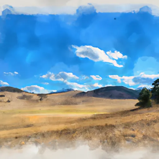
1. Scenic Beauty: Valles Caldera is a large volcanic crater with spectacular views of mountains, meadows, and forests. The preserve is characterized by its diverse ecosystems and breathtaking landscapes.
2. Outdoor Recreation: The area offers plenty of recreational activities, such as hiking, fishing, mountain biking, horseback riding, and wildlife viewing. There are numerous trails that cater to various skill levels, allowing visitors to explore the picturesque surroundings.
3. Cultural and Historical Significance: The preserve holds cultural and historical importance, being home to the Jemez Pueblo people for centuries. Visitors can learn about the area's rich Native American heritage and history.
Points of Interest:
1. Valle Grande: This is the heart of the preserve, a massive grassy valley that was created by a volcanic eruption over a million years ago. It offers stunning panoramic views and is a great spot for wildlife observation.
2. Fishing and Picnicking: The preserve is known for its excellent fishing opportunities, with numerous streams and ponds teeming with trout. Many visitors enjoy picnicking by the water while enjoying the serene surroundings.
3. Trails: Valles Caldera has a network of trails that cater to different abilities and interests. The Cerro Grande Trail, Coyote Call Trail, and Redondo Creek Trail are just a few examples that offer diverse landscapes and wildlife encounters.
Interesting Facts:
1. Valles Caldera is one of the few smaller volcanic calderas in the world and is considered a supervolcano.
2. The preserve spans over 89,000 acres and is managed by the National Park Service.
3. It was once privately owned but was purchased by the federal government in 2000 to preserve its unique features and promote public access.
4. The area is home to a rich biodiversity, including elk, mule deer, black bears, and a variety of bird species.
Best Time of Year to Visit:
The best time to visit Valles Caldera National Preserve is during the summer and early fall months, from June to October. During this time, the weather is generally mild, and the wildflowers are in bloom. Additionally, wildlife is more active, and the streams are well-stocked for fishing enthusiasts. However, it's always recommended to check the preserve's website or contact the National Park Service for up-to-date information on road and trail conditions, as well as any specific activities or events happening during your planned visit.
Please note that while efforts have been made to ensure accuracy, it is always advisable to verify information from multiple independent sources.
Snowpack in Valles Caldera National Preserve
Current snow depth at SNOTEL stations inside the park boundary.
Trails in Valles Caldera National Preserve
Named trails whose route falls inside the park.
Points of interest in Valles Caldera National Preserve
Landmarks and points of interest inside the park boundary.


Plan your visit down to the hour
Same weather feed Snoflo's iOS app uses -- updated continuously from NOAA / yr.no.
Next 5 days, hour by hour
Temperature line with weather symbols on top, snow + rain accumulation as columns, humidity as a dotted line.
5-day forecast table
Every 3 hours, broken out across temperature, snow, rain, humidity, and wind.
| Time | Condition | Temp (°F) | Snow (in) | Rain (in) | Humidity (%) | Wind (mps) | Wind dir |
|---|---|---|---|---|---|---|---|
| Loading detailed forecast… | |||||||
15-day temperature & precipitation
Daily temperatures, snow, and rain projected over the next two weeks.
Responsible recreation & Leave No Trace
- Know before you go
- Check the operator's site for hours, permit requirements, seasonal closures, and fire restrictions before heading out.
- Stay on trail
- Stick to marked paths to protect vegetation, prevent erosion, and avoid disturbing wildlife habitat.
- Respect wildlife
- Observe from a distance, never feed wildlife, and store food securely if camping is permitted on-site.
- Pack it in, pack it out
- Carry out all trash, food scraps, and gear. Many parks have limited or no trash service.
- Leave what you find
- Don't take rocks, plants, or artifacts. They make the park what it is for the next visitor.
Set push alerts in the Snoflo app
Save Valles Caldera National Preserve as a favorite, set a custom threshold (precipitation, freezing temperatures, fire-restriction days), and the iOS app will push the moment conditions cross.
About Valles Caldera National Preserve
What can I do at Valles Caldera National Preserve?
Most Snoflo-tracked parks support hiking, picnicking, and wildlife viewing. Check the operator's site for activity-specific rules (camping, fishing, paddling, hunting).
How fresh is the weather data?
The hourly forecast updates throughout the day from NOAA / yr.no. Streamflow comes live from USGS streamgauges.
When is the best time to visit?
Use the 15-day temperature & precipitation outlook on this page to plan -- pick a window with comfortable temperatures and low precipitation.
How do I get to Valles Caldera National Preserve?
Tap Directions in the hero above to open driving directions in Google Maps, or Open in map to center the Snoflo interactive map on the park.
Can I get alerts when conditions change?
Yes -- alerts are managed in the Snoflo iOS app. Favorite this park, set a threshold (temperature, precipitation), and you'll get a push the moment it crosses.
Park & land designation reference
A quick legend for the federal and state land categories Snoflo tracks. Each designation comes with different rules around access, recreation, and resource extraction.
- National Park
- Large protected natural areas managed by the federal government to preserve significant landscapes, ecosystems, and cultural resources; recreation is allowed but conservation is the priority.
- State Park
- Public natural or recreational areas managed by a state government, typically smaller than national parks and focused on regional natural features, recreation, and education.
- Local Park
- Community-level parks managed by cities or counties, emphasizing recreation, playgrounds, sports, and green space close to populated areas.
- Wilderness Area
- The highest level of land protection in the U.S.; designated areas where nature is left essentially untouched, with no roads, structures, or motorized motorized access permitted.
- National Recreation Area
- Areas set aside primarily for outdoor recreation (boating, hiking, fishing, often around reservoirs, rivers, or scenic landscapes); may allow more development.
- National Conservation Area (BLM)
- BLM-managed areas with special ecological, cultural, or scientific value; more protection than typical BLM land but less strict than Wilderness Areas.
- State Forest
- State-managed forests focused on habitat, watershed, recreation, and sustainable timber harvest.
- Bureau of Land Management (BLM) Land
- Vast federal lands managed for mixed use -- recreation, grazing, mining, conservation -- with fewer restrictions than national parks or forests.