Ukiah-Dale Forest State Scenic Corridor
Community Reviews
Been here? Share the conditions.
Reviews, ratings & photos are added in the free Snoflo iOS app — rate a spot, tag the conditions, and your visit is verified by location. Add or manage your reviews from the app.
Ukiah-Dale Forest State Scenic Corridor
Reasons to Visit:
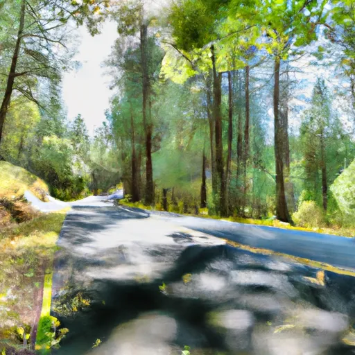
1. Scenic Beauty: The Ukiah-Dale Forest State Scenic Corridor is renowned for its breathtaking landscapes and abundant natural beauty. Visitors can indulge in panoramic vistas of rolling hills, meandering streams, lush forests, and vibrant wildflowers.
2. Outdoor Recreation: The area provides excellent opportunities for outdoor activities such as hiking, picnicking, wildlife observation, and photography. Its well-maintained trails cater to both casual strollers and experienced hikers.
3. Tranquility and Solitude: The corridor's remote location creates a tranquil and serene atmosphere, making it an ideal destination for those seeking peace and solitude. Visitors can escape the hustle and bustle of urban life, immersing themselves in the surrounding nature.
4. Historical Significance: The corridor holds historical importance as it was once traversed by Native Americans, trappers, and settlers during the westward expansion. Exploring the area provides a chance to connect with Oregon's rich past.
Points of Interest:
1. Dale Reservoir: This beautiful reservoir located within the corridor offers stunning views and fishing opportunities. Additionally, it serves as a habitat for various waterfowl and migratory birds.
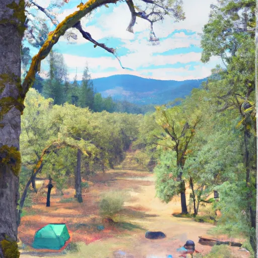
2. Ukiah-Dale Campground: Visitors can enjoy camping at the well-maintained campground within the corridor. It provides facilities such as picnic tables, fire rings, and restrooms, making it an excellent spot for overnight stays.
3. North Fork John Day River: The scenic river runs through the corridor, offering visitors the chance to enjoy swimming, fishing, and kayaking in its clear waters.
4. Wildlife Viewing: The corridor is home to diverse wildlife, including deer, elk, eagles, hawks, and numerous bird species. Nature enthusiasts can spot and appreciate these creatures in their natural habitats.
Interesting Facts:
1. The Ukiah-Dale Forest State Scenic Corridor covers an area of approximately 31,000 acres in northeastern Oregon.
2. The corridor is characterized by a mix of forested areas, open meadows, and rugged canyons, providing a diverse landscape for exploration.
3. It is part of the Blue Mountain Scenic Byway, a renowned scenic drive that showcases the natural beauty of Oregon's Blue Mountains.
4. The corridor is managed by the Oregon Parks and Recreation Department, ensuring the preservation and maintenance of its natural and historical features.
Best Time to Visit:
The best time to visit the Ukiah-Dale Forest State Scenic Corridor is during the summer and early fall months. The weather is generally pleasant, allowing visitors to enjoy outdoor activities comfortably. Spring brings vibrant wildflowers and lush greenery, while fall offers stunning foliage colors. However, it is essential to check the weather forecasts and road conditions before visiting, as the area can experience snowfall and closures during winter months.
Sources:
- Oregon State Parks: https://stateparks.oregon.gov/index.cfm?do=park.profile&parkId=65
- USDA Forest Service: https://www.fs.usda.gov/recarea/umatilla/recarea/?recid=56680
- Travel Oregon: https://traveloregon.com/things-to-do/attractions/parks-forests-wildlife-areas/ukiah-dale-forest-state-scenic-corridor/
Camping in Ukiah-Dale Forest State Scenic Corridor
Campgrounds inside the park, with today's conditions score.
Plan your visit down to the hour
Same weather feed Snoflo's iOS app uses -- updated continuously from NOAA / yr.no.
Next 5 days, hour by hour
Temperature line with weather symbols on top, snow + rain accumulation as columns, humidity as a dotted line.
5-day forecast table
Every 3 hours, broken out across temperature, snow, rain, humidity, and wind.
| Time | Condition | Temp (°F) | Snow (in) | Rain (in) | Humidity (%) | Wind (mps) | Wind dir |
|---|---|---|---|---|---|---|---|
| Loading detailed forecast… | |||||||
15-day temperature & precipitation
Daily temperatures, snow, and rain projected over the next two weeks.
Responsible recreation & Leave No Trace
- Know before you go
- Check the operator's site for hours, permit requirements, seasonal closures, and fire restrictions before heading out.
- Stay on trail
- Stick to marked paths to protect vegetation, prevent erosion, and avoid disturbing wildlife habitat.
- Respect wildlife
- Observe from a distance, never feed wildlife, and store food securely if camping is permitted on-site.
- Pack it in, pack it out
- Carry out all trash, food scraps, and gear. Many parks have limited or no trash service.
- Leave what you find
- Don't take rocks, plants, or artifacts. They make the park what it is for the next visitor.
Set push alerts in the Snoflo app
Save Ukiah-Dale Forest State Scenic Corridor as a favorite, set a custom threshold (precipitation, freezing temperatures, fire-restriction days), and the iOS app will push the moment conditions cross.
About Ukiah-Dale Forest State Scenic Corridor
What can I do at Ukiah-Dale Forest State Scenic Corridor?
Most Snoflo-tracked parks support hiking, picnicking, and wildlife viewing. Check the operator's site for activity-specific rules (camping, fishing, paddling, hunting).
How fresh is the weather data?
The hourly forecast updates throughout the day from NOAA / yr.no. Streamflow comes live from USGS streamgauges.
When is the best time to visit?
Use the 15-day temperature & precipitation outlook on this page to plan -- pick a window with comfortable temperatures and low precipitation.
How do I get to Ukiah-Dale Forest State Scenic Corridor?
Tap Directions in the hero above to open driving directions in Google Maps, or Open in map to center the Snoflo interactive map on the park.
Can I get alerts when conditions change?
Yes -- alerts are managed in the Snoflo iOS app. Favorite this park, set a threshold (temperature, precipitation), and you'll get a push the moment it crosses.
Park & land designation reference
A quick legend for the federal and state land categories Snoflo tracks. Each designation comes with different rules around access, recreation, and resource extraction.
- National Park
- Large protected natural areas managed by the federal government to preserve significant landscapes, ecosystems, and cultural resources; recreation is allowed but conservation is the priority.
- State Park
- Public natural or recreational areas managed by a state government, typically smaller than national parks and focused on regional natural features, recreation, and education.
- Local Park
- Community-level parks managed by cities or counties, emphasizing recreation, playgrounds, sports, and green space close to populated areas.
- Wilderness Area
- The highest level of land protection in the U.S.; designated areas where nature is left essentially untouched, with no roads, structures, or motorized motorized access permitted.
- National Recreation Area
- Areas set aside primarily for outdoor recreation (boating, hiking, fishing, often around reservoirs, rivers, or scenic landscapes); may allow more development.
- National Conservation Area (BLM)
- BLM-managed areas with special ecological, cultural, or scientific value; more protection than typical BLM land but less strict than Wilderness Areas.
- State Forest
- State-managed forests focused on habitat, watershed, recreation, and sustainable timber harvest.
- Bureau of Land Management (BLM) Land
- Vast federal lands managed for mixed use -- recreation, grazing, mining, conservation -- with fewer restrictions than national parks or forests.