San Antonio Missions National Historic Site
Community Reviews
Been here? Share the conditions.
Reviews, ratings & photos are added in the free Snoflo iOS app — rate a spot, tag the conditions, and your visit is verified by location. Add or manage your reviews from the app.
San Antonio Missions National Historic Site
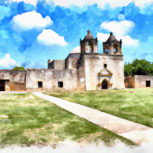
There are several compelling reasons to visit the San Antonio Missions National Historic Site. Firstly, it offers a unique opportunity to delve into the rich history of the Spanish colonial era in Texas. The missions provide insights into the daily lives of Native American converts and Spanish missionaries, showcasing their architecture, agricultural practices, and religious customs.
Each of the five missions within the historic site has its own distinct points of interest. The Alamo, the most famous mission, is renowned for its pivotal role in the Texas Revolution. Mission San José, known as the "Queen of the Missions," is notable for its beautifully preserved church and granary, providing a glimpse into the mission's former grandeur. Mission Concepción offers a remarkable example of original frescoes within its church, while Mission San Juan Capistrano showcases an operational farm providing a taste of the mission's agricultural history. Finally, Mission Espada is recognized for its unique aqueduct system, which once irrigated the surrounding farmland.
Interesting facts about the San Antonio Missions National Historic Site include their inscription as a UNESCO World Heritage site in 2015, highlighting their global cultural significance. Additionally, the missions became part of the National Park Service in 1978, allowing for their preservation and public accessibility.
The best time to visit the San Antonio Missions National Historic Site is during the spring or fall when the weather is pleasant and the crowds are relatively smaller compared to the peak summer months. However, it is worth noting that the missions can be visited year-round. It is advisable to check the official National Park Service website or contact the visitor center for the most accurate and up-to-date information regarding the site's operating hours and any seasonal events or programs.
To ensure accuracy, it is recommended to verify the information provided across multiple independent sources, such as the National Park Service, UNESCO, and reputable travel guides or websites.
Trails in San Antonio Missions National Historic Site
Named trails whose route falls inside the park.
Plan your visit down to the hour
Same weather feed Snoflo's iOS app uses -- updated continuously from NOAA / yr.no.
Next 5 days, hour by hour
Temperature line with weather symbols on top, snow + rain accumulation as columns, humidity as a dotted line.
5-day forecast table
Every 3 hours, broken out across temperature, snow, rain, humidity, and wind.
| Time | Condition | Temp (°F) | Snow (in) | Rain (in) | Humidity (%) | Wind (mps) | Wind dir |
|---|---|---|---|---|---|---|---|
| Loading detailed forecast… | |||||||
15-day temperature & precipitation
Daily temperatures, snow, and rain projected over the next two weeks.
Responsible recreation & Leave No Trace
- Know before you go
- Check the operator's site for hours, permit requirements, seasonal closures, and fire restrictions before heading out.
- Stay on trail
- Stick to marked paths to protect vegetation, prevent erosion, and avoid disturbing wildlife habitat.
- Respect wildlife
- Observe from a distance, never feed wildlife, and store food securely if camping is permitted on-site.
- Pack it in, pack it out
- Carry out all trash, food scraps, and gear. Many parks have limited or no trash service.
- Leave what you find
- Don't take rocks, plants, or artifacts. They make the park what it is for the next visitor.
Set push alerts in the Snoflo app
Save San Antonio Missions National Historic Site as a favorite, set a custom threshold (precipitation, freezing temperatures, fire-restriction days), and the iOS app will push the moment conditions cross.
About San Antonio Missions National Historic Site
What can I do at San Antonio Missions National Historic Site?
Most Snoflo-tracked parks support hiking, picnicking, and wildlife viewing. Check the operator's site for activity-specific rules (camping, fishing, paddling, hunting).
How fresh is the weather data?
The hourly forecast updates throughout the day from NOAA / yr.no. Streamflow comes live from USGS streamgauges.
When is the best time to visit?
Use the 15-day temperature & precipitation outlook on this page to plan -- pick a window with comfortable temperatures and low precipitation.
How do I get to San Antonio Missions National Historic Site?
Tap Directions in the hero above to open driving directions in Google Maps, or Open in map to center the Snoflo interactive map on the park.
Can I get alerts when conditions change?
Yes -- alerts are managed in the Snoflo iOS app. Favorite this park, set a threshold (temperature, precipitation), and you'll get a push the moment it crosses.
Park & land designation reference
A quick legend for the federal and state land categories Snoflo tracks. Each designation comes with different rules around access, recreation, and resource extraction.
- National Park
- Large protected natural areas managed by the federal government to preserve significant landscapes, ecosystems, and cultural resources; recreation is allowed but conservation is the priority.
- State Park
- Public natural or recreational areas managed by a state government, typically smaller than national parks and focused on regional natural features, recreation, and education.
- Local Park
- Community-level parks managed by cities or counties, emphasizing recreation, playgrounds, sports, and green space close to populated areas.
- Wilderness Area
- The highest level of land protection in the U.S.; designated areas where nature is left essentially untouched, with no roads, structures, or motorized motorized access permitted.
- National Recreation Area
- Areas set aside primarily for outdoor recreation (boating, hiking, fishing, often around reservoirs, rivers, or scenic landscapes); may allow more development.
- National Conservation Area (BLM)
- BLM-managed areas with special ecological, cultural, or scientific value; more protection than typical BLM land but less strict than Wilderness Areas.
- State Forest
- State-managed forests focused on habitat, watershed, recreation, and sustainable timber harvest.
- Bureau of Land Management (BLM) Land
- Vast federal lands managed for mixed use -- recreation, grazing, mining, conservation -- with fewer restrictions than national parks or forests.