The Channels State Natural Area Preserve
Community Reviews
Been here? Share the conditions.
Reviews, ratings & photos are added in the free Snoflo iOS app — rate a spot, tag the conditions, and your visit is verified by location. Add or manage your reviews from the app.
The Channels State Natural Area Preserve
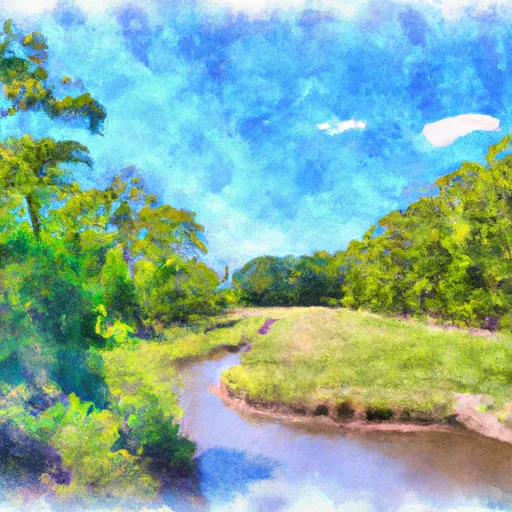
One compelling reason to visit the Channels State Natural Area Preserve is to explore its iconic rock maze. The highlight of the preserve is a labyrinth of sandstone formations that resemble narrow, winding channels, hence the name. This natural wonder offers a thrilling challenge to hikers and rock climbers, as they navigate through the maze-like passages and discover hidden caves and crevices.
Apart from the mesmerizing rock formations, the preserve is home to a rich variety of plant and animal species. Nature enthusiasts will be delighted to spot rare wildflowers, such as the Virginia spiderwort and the wild columbine, as well as a diverse array of bird species, including the indigo bunting and scarlet tanager. The area's biodiversity is truly a sight to behold, providing ample opportunities for wildlife observation and photography.
Interesting facts about the Channels State Natural Area Preserve include its origin, which is believed to be the result of weathering and erosion that occurred over thousands of years. The channels themselves were likely formed by water running through vertical cracks in the sandstone. Additionally, the area has significant geological and ecological value, and it became a state natural area preserve in 2008 to ensure its preservation and protection.
The best time of year to visit the Channels State Natural Area Preserve is during the spring and fall seasons. In the spring, the wildflowers are in full bloom, creating a vivid and colorful landscape. Fall brings stunning foliage, as the leaves of the surrounding trees transform into vibrant shades of red, orange, and yellow. The summer months can be hot, while winter might make hiking more challenging due to icy conditions, so it is advisable to plan accordingly.
To ensure the accuracy of the information provided, it is recommended to verify these details across multiple independent sources, such as the official website of the Virginia Department of Conservation and Recreation and local tourism websites or guidebooks.
Plan your visit down to the hour
Same weather feed Snoflo's iOS app uses -- updated continuously from NOAA / yr.no.
Next 5 days, hour by hour
Temperature line with weather symbols on top, snow + rain accumulation as columns, humidity as a dotted line.
5-day forecast table
Every 3 hours, broken out across temperature, snow, rain, humidity, and wind.
| Time | Condition | Temp (°F) | Snow (in) | Rain (in) | Humidity (%) | Wind (mps) | Wind dir |
|---|---|---|---|---|---|---|---|
| Loading detailed forecast… | |||||||
15-day temperature & precipitation
Daily temperatures, snow, and rain projected over the next two weeks.
Responsible recreation & Leave No Trace
- Know before you go
- Check the operator's site for hours, permit requirements, seasonal closures, and fire restrictions before heading out.
- Stay on trail
- Stick to marked paths to protect vegetation, prevent erosion, and avoid disturbing wildlife habitat.
- Respect wildlife
- Observe from a distance, never feed wildlife, and store food securely if camping is permitted on-site.
- Pack it in, pack it out
- Carry out all trash, food scraps, and gear. Many parks have limited or no trash service.
- Leave what you find
- Don't take rocks, plants, or artifacts. They make the park what it is for the next visitor.
Set push alerts in the Snoflo app
Save The Channels State Natural Area Preserve as a favorite, set a custom threshold (precipitation, freezing temperatures, fire-restriction days), and the iOS app will push the moment conditions cross.
About The Channels State Natural Area Preserve
What can I do at The Channels State Natural Area Preserve?
Most Snoflo-tracked parks support hiking, picnicking, and wildlife viewing. Check the operator's site for activity-specific rules (camping, fishing, paddling, hunting).
How fresh is the weather data?
The hourly forecast updates throughout the day from NOAA / yr.no. Streamflow comes live from USGS streamgauges.
When is the best time to visit?
Use the 15-day temperature & precipitation outlook on this page to plan -- pick a window with comfortable temperatures and low precipitation.
How do I get to The Channels State Natural Area Preserve?
Tap Directions in the hero above to open driving directions in Google Maps, or Open in map to center the Snoflo interactive map on the park.
Can I get alerts when conditions change?
Yes -- alerts are managed in the Snoflo iOS app. Favorite this park, set a threshold (temperature, precipitation), and you'll get a push the moment it crosses.
Park & land designation reference
A quick legend for the federal and state land categories Snoflo tracks. Each designation comes with different rules around access, recreation, and resource extraction.
- National Park
- Large protected natural areas managed by the federal government to preserve significant landscapes, ecosystems, and cultural resources; recreation is allowed but conservation is the priority.
- State Park
- Public natural or recreational areas managed by a state government, typically smaller than national parks and focused on regional natural features, recreation, and education.
- Local Park
- Community-level parks managed by cities or counties, emphasizing recreation, playgrounds, sports, and green space close to populated areas.
- Wilderness Area
- The highest level of land protection in the U.S.; designated areas where nature is left essentially untouched, with no roads, structures, or motorized motorized access permitted.
- National Recreation Area
- Areas set aside primarily for outdoor recreation (boating, hiking, fishing, often around reservoirs, rivers, or scenic landscapes); may allow more development.
- National Conservation Area (BLM)
- BLM-managed areas with special ecological, cultural, or scientific value; more protection than typical BLM land but less strict than Wilderness Areas.
- State Forest
- State-managed forests focused on habitat, watershed, recreation, and sustainable timber harvest.
- Bureau of Land Management (BLM) Land
- Vast federal lands managed for mixed use -- recreation, grazing, mining, conservation -- with fewer restrictions than national parks or forests.