South Whidbey State Park
Community Reviews
Been here? Share the conditions.
Reviews, ratings & photos are added in the free Snoflo iOS app — rate a spot, tag the conditions, and your visit is verified by location. Add or manage your reviews from the app.
South Whidbey State Park
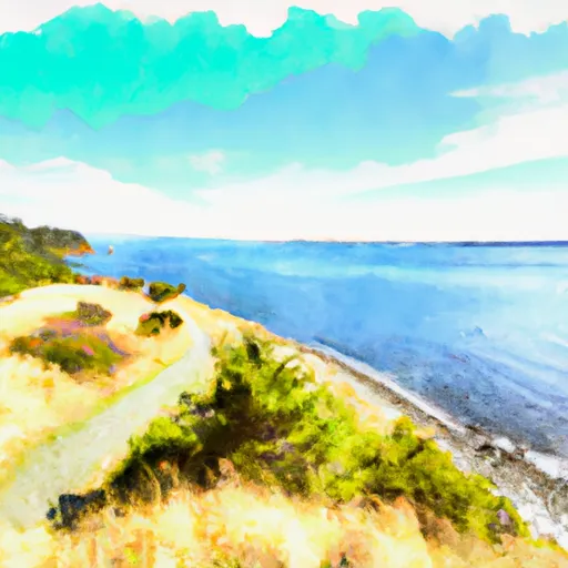
One of the main reasons to visit South Whidbey State Park is its breathtaking scenery. With its lush forested areas, picturesque hiking trails, and sweeping views of the Puget Sound, the park provides a tranquil escape into nature. Visitors can enjoy birdwatching, picnicking, and strolling along the shoreline while soaking in the serene ambiance.
The park features several points of interest worth exploring. The 347-acre park encompasses old-growth forest, wetlands, and over 4,500 feet of saltwater shoreline. Hiking enthusiasts can traverse the four miles of well-maintained trails, taking them through diverse ecosystems and offering glimpses of wildlife such as deer, rabbits, and various bird species. The park also provides opportunities for fishing, crabbing, clamming, and beachcombing, ensuring there is something to suit every outdoor enthusiast's taste.
For history buffs, South Whidbey State Park holds interesting facts about the area's past. It served as a site for a logging camp in the early 20th century and was later purchased by the state to preserve its natural beauty. The remnants of the logging era can still be seen within the park, adding a historical element to the overall experience.
The best time to visit South Whidbey State Park largely depends on individual preferences. Spring and summer offer pleasant weather with blooming wildflowers and the opportunity to enjoy water-based activities like kayaking and paddleboarding. Fall showcases vibrant foliage, creating a picturesque atmosphere for hiking and photography. Winter, although rainy, can provide a peaceful and secluded experience for those seeking solitude and tranquility.
To ensure accuracy, it is advisable to verify information about South Whidbey State Park from multiple independent sources, such as official park websites, travel guides, or reputable online platforms dedicated to outdoor recreation and state parks.
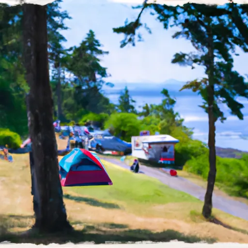
Camping in South Whidbey State Park
Campgrounds inside the park, with today's conditions score.
Plan your visit down to the hour
Same weather feed Snoflo's iOS app uses -- updated continuously from NOAA / yr.no.
Next 5 days, hour by hour
Temperature line with weather symbols on top, snow + rain accumulation as columns, humidity as a dotted line.
5-day forecast table
Every 3 hours, broken out across temperature, snow, rain, humidity, and wind.
| Time | Condition | Temp (°F) | Snow (in) | Rain (in) | Humidity (%) | Wind (mps) | Wind dir |
|---|---|---|---|---|---|---|---|
| Loading detailed forecast… | |||||||
15-day temperature & precipitation
Daily temperatures, snow, and rain projected over the next two weeks.
Responsible recreation & Leave No Trace
- Know before you go
- Check the operator's site for hours, permit requirements, seasonal closures, and fire restrictions before heading out.
- Stay on trail
- Stick to marked paths to protect vegetation, prevent erosion, and avoid disturbing wildlife habitat.
- Respect wildlife
- Observe from a distance, never feed wildlife, and store food securely if camping is permitted on-site.
- Pack it in, pack it out
- Carry out all trash, food scraps, and gear. Many parks have limited or no trash service.
- Leave what you find
- Don't take rocks, plants, or artifacts. They make the park what it is for the next visitor.
Set push alerts in the Snoflo app
Save South Whidbey State Park as a favorite, set a custom threshold (precipitation, freezing temperatures, fire-restriction days), and the iOS app will push the moment conditions cross.
About South Whidbey State Park
What can I do at South Whidbey State Park?
Most Snoflo-tracked parks support hiking, picnicking, and wildlife viewing. Check the operator's site for activity-specific rules (camping, fishing, paddling, hunting).
How fresh is the weather data?
The hourly forecast updates throughout the day from NOAA / yr.no. Streamflow comes live from USGS streamgauges.
When is the best time to visit?
Use the 15-day temperature & precipitation outlook on this page to plan -- pick a window with comfortable temperatures and low precipitation.
How do I get to South Whidbey State Park?
Tap Directions in the hero above to open driving directions in Google Maps, or Open in map to center the Snoflo interactive map on the park.
Can I get alerts when conditions change?
Yes -- alerts are managed in the Snoflo iOS app. Favorite this park, set a threshold (temperature, precipitation), and you'll get a push the moment it crosses.
Park & land designation reference
A quick legend for the federal and state land categories Snoflo tracks. Each designation comes with different rules around access, recreation, and resource extraction.
- National Park
- Large protected natural areas managed by the federal government to preserve significant landscapes, ecosystems, and cultural resources; recreation is allowed but conservation is the priority.
- State Park
- Public natural or recreational areas managed by a state government, typically smaller than national parks and focused on regional natural features, recreation, and education.
- Local Park
- Community-level parks managed by cities or counties, emphasizing recreation, playgrounds, sports, and green space close to populated areas.
- Wilderness Area
- The highest level of land protection in the U.S.; designated areas where nature is left essentially untouched, with no roads, structures, or motorized motorized access permitted.
- National Recreation Area
- Areas set aside primarily for outdoor recreation (boating, hiking, fishing, often around reservoirs, rivers, or scenic landscapes); may allow more development.
- National Conservation Area (BLM)
- BLM-managed areas with special ecological, cultural, or scientific value; more protection than typical BLM land but less strict than Wilderness Areas.
- State Forest
- State-managed forests focused on habitat, watershed, recreation, and sustainable timber harvest.
- Bureau of Land Management (BLM) Land
- Vast federal lands managed for mixed use -- recreation, grazing, mining, conservation -- with fewer restrictions than national parks or forests.