South Whidbey Island State Park Campground
Community Reviews
Been here? Share the conditions.
Reviews, ratings & photos are added in the free Snoflo iOS app — rate a spot, tag the conditions, and your visit is verified by location. Add or manage your reviews from the app.
South Whidbey Island State Park
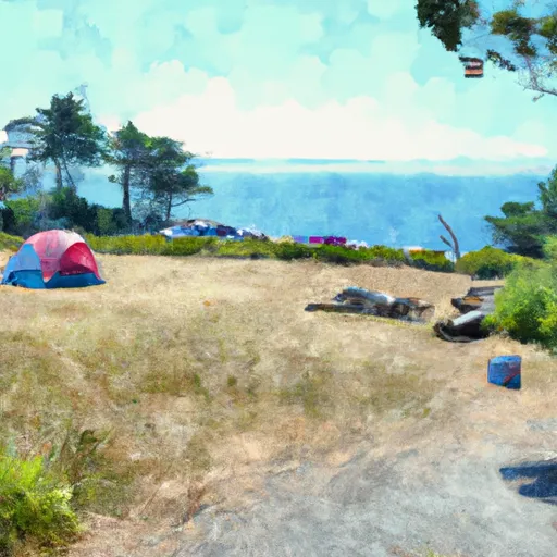
Reservations are accepted at South Whidbey Island State Park, which is recommended especially during the peak tourist season. The campground offers both tent and RV sites, with electrical hookups available for RVs. Campers can enjoy the tranquility of the park's forests and the stunning views of the surrounding water and mountains.
The best time to visit South Whidbey Island State Park is during the summer months when the weather is pleasant and conducive to outdoor activities. This is also the busiest time, so advanced reservations are highly recommended. It is important to note that the park has a one-week maximum stay limit, so campers should plan their visit accordingly.
While camping at South Whidbey Island State Park, visitors should be cautious of wildlife, such as raccoons and deer, who may be attracted to food left unattended. Campers are advised to store food securely to prevent any unwanted encounters. Additionally, it is important to keep the campsite clean and follow proper waste disposal procedures to preserve the natural beauty of the area.
Overall, South Whidbey Island State Park is a wonderful camping destination that offers a range of amenities and beautiful surroundings. Whether visitors are seeking relaxation, outdoor adventure, or a peaceful retreat, this campground provides an enjoyable experience for all.
What's on-site at South Whidbey Island State Park
Key facilities Snoflo tracks for this campground. Confirm with the operator before booking -- amenities can change seasonally.
Plan your trip down to the hour
Same weather feed Snoflo's iOS app uses -- updated continuously from NOAA / yr.no.
Next 5 days, hour by hour
Temperature line with weather symbols on top, snow + rain accumulation as columns, humidity as a dotted line.
5-day forecast table
Every 3 hours, broken out across temperature, snow, rain, humidity, and wind. Each cell is colour-coded relative to the column min/max so trends jump out at a glance.
| Time | Condition | Temp (°F) | Snow (in) | Rain (in) | Humidity (%) | Wind (mps) | Wind dir |
|---|---|---|---|---|---|---|---|
| Loading detailed forecast… | |||||||
15-day temperature & precipitation
Daily temperatures, snow, and rain projected over the next two weeks. Hover any point for the full breakdown.
Other campgrounds in the area
Snoflo-tracked campsites within driving distance of South Whidbey Island State Park, with reservations status.
| Campground | Reservations | Toilets | View |
|---|---|---|---|
| South Whidbey State Park | ✗ | ✗ | → |
| Cascade Marine Trail, Campsite For Human Powered Boats | ✗ | ✗ | → |
| Fort Flagler State Park | ✓ | ✗ | → |
| Hiker/Cyclists Campsite | ✗ | ✗ | → |
| Camano Island State Park (Cmt) | ✗ | ✗ | → |
Nearby streamflow
USGS streamgauges within reach of South Whidbey Island State Park -- pulled live from the National Water Information System.
| Streamgauge | Discharge | View |
|---|---|---|
| Tulalip Creek Near Tulalip | 7 cfs | → |
| Tulalip Creek Above East Branch Near Tulalip | 4 cfs | → |
| East Branch Tulalip Creek Nr Mouth Nr Tulalip | 2 cfs | → |
| Mission Creek Near Tulalip | 1 cfs | → |
| Dungeness River Near Sequim | 116 cfs | → |
| Pilchuck River Near Snohomish | 72 cfs | → |
Nearby snow depths
NRCS SNOTEL stations within reach of South Whidbey Island State Park -- relevant when planning a shoulder-season or alpine trip.
| SNOTEL station | Snowpack | 24h Snowfall | View |
|---|---|---|---|
| Dungeness | 0.0 in | -1.0 in | → |
| Dungeness | 4.0 in | 0.0 in | → |
| Mount Crag | 0.0 in | 0.0 in | → |
| Nohrsc Mount Crag | 0.0 in | 0.0 in | → |
| Waterhole | 0.0 in | 0.0 in | → |
| Nohrsc Waterhole | 0.0 in | 0.0 in | → |
Plan a longer trip
The closest parks, lakes, boat launches, and paddle runs so a camping night can grow into a full weekend.
Parks
- South Whidbey State Park
- Freeland County Park
- East Beach Park
- Mystery Bay State Park
- Fort Flagler State Park
- Jefferson County Park
Boat launches
- Bush Point Resort
- Seashore Avenue Island County
- East Shoreview Drive 1543, Freeland
- Mystery Bay State Park
- Mutiny Bay
- Lake Goss
Points of interest
- Ancient Cedar
- Fire Of The Heart Gallery
- Marrowstone Point Lighthouse
- Fort Casey
- Admiralty Head Lighthouse
- South Whidbey Historical Museum
Paddle runs
- Canyon Creek To Confluence With North Fork Stillaguamish River
- Usfs Road 2870 Bridge To Confluence With Dungeness River
- Silver Creek To Sleepy Hollow Creek
- Sleepy Hollow Creek To Olympic Nf Boundary
- Olympic Nf/Olympic Np Boundary To Usfs Road 2870 Bridge
- Forest Road 2860 Bridge To Silver Creek
Camping essentials & Leave No Trace
- Pack it in, pack it out
- Take all trash, food scraps, and gear back with you to keep campsites clean and protect wildlife.
- Respect wildlife
- Observe animals from a distance, store food securely, and never feed wildlife to maintain natural behavior and safety.
- Know before you go
- Check weather, fire restrictions, trail conditions, and permit requirements to ensure a safe and well-planned trip.
- Minimize campfire impact
- Use established fire rings, keep fires small, fully extinguish them, or opt for a camp stove when fires are restricted.
- Leave what you find
- Preserve natural and cultural features by avoiding removal of plants, rocks, artifacts, or other elements of the environment.
Set push alerts in the Snoflo app
Save South Whidbey Island State Park as a favorite, set a custom threshold (precipitation, snowpack, freezing temperatures), and the iOS app will push the moment conditions cross.
About South Whidbey Island State Park
Can I make reservations at South Whidbey Island State Park?
Yes -- this campground accepts reservations. Snoflo recommends booking early for peak season; check the operator (Recreation.gov / state park system / private operator) for the booking window and cancellation policy.
How fresh is the weather data on this page?
The hourly forecast updates throughout the day from the NOAA / yr.no public feeds. Streamflow data is pulled live from USGS streamgauges and snowpack from the NRCS SNOTEL network.
What's the best time of year to visit?
Use the 15-day temperature & precipitation outlook on this page to plan -- pick a window with comfortable temperatures and low precipitation. For longer trips, the 5-day hourly meteogram shows snow + rain accumulation hour-by-hour.
How do I get to South Whidbey Island State Park?
Tap Directions in the hero above to open driving directions in Google Maps, or Open in map to center the Snoflo interactive map on the campground.
Can I get alerts when conditions change?
Yes -- alerts are managed through the Snoflo iOS app. Favorite this campground, set a threshold (temperature, snowpack, precipitation), and you'll get a push the moment it crosses.
Other campgrounds near here
Snoflo-tracked campgrounds within driving distance of South Whidbey Island State Park.