Community Reviews
Been here? Share the conditions.
Reviews, ratings & photos are added in the free Snoflo iOS app — rate a spot, tag the conditions, and your visit is verified by location. Add or manage your reviews from the app.
Watoga State Park
Reasons to Visit:
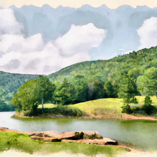
1. Natural Beauty: Watoga State Park spans over 10,100 acres of rolling hills, dense forests, and meandering streams. The park's scenic beauty provides a serene and peaceful atmosphere for visitors.
2. Outdoor Recreation: The park offers numerous outdoor activities, including hiking, mountain biking, fishing, swimming, boating, and picnicking. With a vast network of trails, visitors can explore the park's wilderness and observe its diverse flora and fauna.
3. Camping Opportunities: Watoga State Park boasts several campgrounds, including tent and RV sites, as well as cozy cabins. These accommodations allow visitors to immerse themselves in nature and enjoy a rustic camping experience.
4. Wildlife Watching: The park is home to a variety of wildlife species, including white-tailed deer, black bears, wild turkeys, and numerous bird species. Wildlife enthusiasts can enjoy observing and photographing these creatures in their natural habitat.
Points of Interest:
1. Ann Bailey Lookout Tower: This 100-foot-tall tower provides panoramic views of the surrounding forested hills and mountains, making it a popular spot for photography and sightseeing.
2. Watoga Lake: A 11-acre lake situated within the park, Watoga Lake offers opportunities for fishing, boating, and swimming. The tranquil setting is perfect for relaxation and enjoying the surrounding natural beauty.
3. The Calvin Price Appalachian Trail Shelter: Located within the park, this shelter provides hikers along the Appalachian Trail a place to rest and take shelter. It is named after Calvin Price, one of the early trail developers of the Appalachian Trail.
4. The Riverside Campground: This campground offers picturesque camping spots along the Greenbrier River, allowing campers to wake up to the soothing sounds of flowing water and enjoy scenic riverside views.
Interesting Facts:
1. Watoga State Park is West Virginia's largest state park, covering an area larger than the city of Charleston.
2. The park was established in 1937 and named after the Native American word for "starry waters."
3. Watoga State Park offers a wide range of interpretive programs, including guided hikes, nature lectures, and craft demonstrations, providing visitors with educational opportunities to learn about the park's natural and cultural history.
Best Time to Visit:
The best time to visit Watoga State Park is during the spring and fall seasons when the weather is mild and the landscape showcases vibrant colors. Springtime brings blooming wildflowers and rushing streams, while autumn paints the park with stunning foliage. Additionally, summer offers opportunities for swimming and boating in Watoga Lake, while winter brings the possibility of snow and ice-related activities for those seeking a winter wonderland experience.
Sources:
- West Virginia State Parks and Forests: Watoga State Park: https://wvstateparks.com/park/watoga-state-park/
- WV Department of Commerce: Watoga State Park: https://www.wvcommerce.org/travel/travelplanner/listing/Watoga-State-Park/493/default.aspx
Trails in Watoga State Park
Named trails whose route falls inside the park.
Plan your visit down to the hour
Same weather feed Snoflo's iOS app uses -- updated continuously from NOAA / yr.no.
Next 5 days, hour by hour
Temperature line with weather symbols on top, snow + rain accumulation as columns, humidity as a dotted line.
5-day forecast table
Every 3 hours, broken out across temperature, snow, rain, humidity, and wind.
| Time | Condition | Temp (°F) | Snow (in) | Rain (in) | Humidity (%) | Wind (mps) | Wind dir |
|---|---|---|---|---|---|---|---|
| Loading detailed forecast… | |||||||
15-day temperature & precipitation
Daily temperatures, snow, and rain projected over the next two weeks.
Responsible recreation & Leave No Trace
- Know before you go
- Check the operator's site for hours, permit requirements, seasonal closures, and fire restrictions before heading out.
- Stay on trail
- Stick to marked paths to protect vegetation, prevent erosion, and avoid disturbing wildlife habitat.
- Respect wildlife
- Observe from a distance, never feed wildlife, and store food securely if camping is permitted on-site.
- Pack it in, pack it out
- Carry out all trash, food scraps, and gear. Many parks have limited or no trash service.
- Leave what you find
- Don't take rocks, plants, or artifacts. They make the park what it is for the next visitor.
Set push alerts in the Snoflo app
Save Watoga State Park as a favorite, set a custom threshold (precipitation, freezing temperatures, fire-restriction days), and the iOS app will push the moment conditions cross.
About Watoga State Park
What can I do at Watoga State Park?
Most Snoflo-tracked parks support hiking, picnicking, and wildlife viewing. Check the operator's site for activity-specific rules (camping, fishing, paddling, hunting).
How fresh is the weather data?
The hourly forecast updates throughout the day from NOAA / yr.no. Streamflow comes live from USGS streamgauges.
When is the best time to visit?
Use the 15-day temperature & precipitation outlook on this page to plan -- pick a window with comfortable temperatures and low precipitation.
How do I get to Watoga State Park?
Tap Directions in the hero above to open driving directions in Google Maps, or Open in map to center the Snoflo interactive map on the park.
Can I get alerts when conditions change?
Yes -- alerts are managed in the Snoflo iOS app. Favorite this park, set a threshold (temperature, precipitation), and you'll get a push the moment it crosses.
Park & land designation reference
A quick legend for the federal and state land categories Snoflo tracks. Each designation comes with different rules around access, recreation, and resource extraction.
- National Park
- Large protected natural areas managed by the federal government to preserve significant landscapes, ecosystems, and cultural resources; recreation is allowed but conservation is the priority.
- State Park
- Public natural or recreational areas managed by a state government, typically smaller than national parks and focused on regional natural features, recreation, and education.
- Local Park
- Community-level parks managed by cities or counties, emphasizing recreation, playgrounds, sports, and green space close to populated areas.
- Wilderness Area
- The highest level of land protection in the U.S.; designated areas where nature is left essentially untouched, with no roads, structures, or motorized motorized access permitted.
- National Recreation Area
- Areas set aside primarily for outdoor recreation (boating, hiking, fishing, often around reservoirs, rivers, or scenic landscapes); may allow more development.
- National Conservation Area (BLM)
- BLM-managed areas with special ecological, cultural, or scientific value; more protection than typical BLM land but less strict than Wilderness Areas.
- State Forest
- State-managed forests focused on habitat, watershed, recreation, and sustainable timber harvest.
- Bureau of Land Management (BLM) Land
- Vast federal lands managed for mixed use -- recreation, grazing, mining, conservation -- with fewer restrictions than national parks or forests.