Beaver Creek - Watoga State Park Campground
Community Reviews
Been here? Share the conditions.
Reviews, ratings & photos are added in the free Snoflo iOS app — rate a spot, tag the conditions, and your visit is verified by location. Add or manage your reviews from the app.
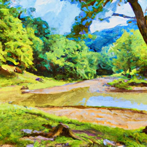
Beaver Creek - Watoga State Park
Reservations are accepted for camping at Beaver Creek, which is highly recommended due to its popularity. It is advisable to make reservations well in advance, especially during peak season, to secure a spot at this picturesque campground. The best time to visit Beaver Creek is during the summer months, from May to September, when the weather is pleasant for outdoor activities such as hiking, fishing, and wildlife viewing. However, it is worth noting that the campground can get crowded during weekends and holidays, so planning a midweek visit might offer a more peaceful experience.
While camping at Beaver Creek, visitors can explore the nearby attractions of Watoga State Park. The park boasts over 40 miles of hiking trails that cater to different skill levels, offering stunning views of the surrounding nature. Fishing enthusiasts can enjoy casting their lines in the park's pristine lakes and streams, which are stocked with various fish species. It is important to be mindful of wildlife in the campground area, including black bears, and to properly store food to avoid attracting them. Moreover, following park rules and regulations is essential to maintain the ecological balance and preserve the natural beauty of this camping area.
What's on-site at Beaver Creek - Watoga State Park
Key facilities Snoflo tracks for this campground. Confirm with the operator before booking -- amenities can change seasonally.
Plan your trip down to the hour
Same weather feed Snoflo's iOS app uses -- updated continuously from NOAA / yr.no.
Next 5 days, hour by hour
Temperature line with weather symbols on top, snow + rain accumulation as columns, humidity as a dotted line.
5-day forecast table
Every 3 hours, broken out across temperature, snow, rain, humidity, and wind. Each cell is colour-coded relative to the column min/max so trends jump out at a glance.
| Time | Condition | Temp (°F) | Snow (in) | Rain (in) | Humidity (%) | Wind (mps) | Wind dir |
|---|---|---|---|---|---|---|---|
| Loading detailed forecast… | |||||||
15-day temperature & precipitation
Daily temperatures, snow, and rain projected over the next two weeks. Hover any point for the full breakdown.
Other campgrounds in the area
Snoflo-tracked campsites within driving distance of Beaver Creek - Watoga State Park, with reservations status.
| Campground | Reservations | Toilets | View |
|---|---|---|---|
| Beaver Creek Campsite | ✗ | ✗ | → |
| Riverside - Watoga State Park | ✓ | ✗ | → |
| Mile 51.5 Campsite | ✗ | ✗ | → |
| Pocahontas | ✗ | ✗ | → |
| Pocahontas Campground | ✗ | ✗ | → |
Nearby streamflow
USGS streamgauges within reach of Beaver Creek - Watoga State Park -- pulled live from the National Water Information System.
| Streamgauge | Discharge | View |
|---|---|---|
| Greenbrier River At Buckeye | 154 cfs | → |
| Back Creek Near Mountain Grove | 32 cfs | → |
| Jackson River Near Bacova | 35 cfs | → |
| Jackson River Bl Gathright Dam Nr Hot Spgs | 240 cfs | → |
| Little Back Creek Near Sunrise | 4 cfs | → |
| Back Creek At Sunrise | 26 cfs | → |
Nearby snow depths
NRCS SNOTEL stations within reach of Beaver Creek - Watoga State Park -- relevant when planning a shoulder-season or alpine trip.
| SNOTEL station | Snowpack | 24h Snowfall | View |
|---|---|---|---|
| Gathright Dam | 0.0 in | 0.0 in | → |
| Hot Springs | 0.0 in | 0.0 in | → |
| Frost 3ne | 0.0 in | 0.0 in | → |
| Covington Filter Plant | 0.0 in | 0.0 in | → |
| Snowshoe | 0.0 in | 0.0 in | → |
| Dunmore 1n | 0.0 in | 0.0 in | → |
Plan a longer trip
The closest parks, lakes, boat launches, and paddle runs so a camping night can grow into a full weekend.
Parks
- Watoga State Park
- Wilderness Spice Run
- Droop Mountain Battlefield State Park
- Beartown State Park
- Wilderness Cranberry
- Seneca State Forest
Boat launches
- Watoga State Park Lake
- Lake Sherwood Road Greenbrier County
- Lake Moomaw Marina
- Coles Point
- Lake Moomaw (Coles Point)
- Jackson River Canoe Access Points
Points of interest
- Pearl S Buck Birthplace
- 4th Avenue Gallery
- Locust Creek Covered Bridge
- Bubble Cave Preserve
- Falls Of Hills Creek
- Bath Community Senior Center
Paddle runs
- Segment A--State Route 39 At Blowing Springs Campground To Lake Moomaw
- Segment C--Southern Boundary Hidden Valley Tract To Mcclintic Bridge
- The Headwaters To The U.S. Forest Service Cranberry Campground
- Segment B--Pump Storage Lake To Blowing Springs Campground
- Tea Creek To Three Forks
- National Forest Land To Tea Creek
Camping essentials & Leave No Trace
- Pack it in, pack it out
- Take all trash, food scraps, and gear back with you to keep campsites clean and protect wildlife.
- Respect wildlife
- Observe animals from a distance, store food securely, and never feed wildlife to maintain natural behavior and safety.
- Know before you go
- Check weather, fire restrictions, trail conditions, and permit requirements to ensure a safe and well-planned trip.
- Minimize campfire impact
- Use established fire rings, keep fires small, fully extinguish them, or opt for a camp stove when fires are restricted.
- Leave what you find
- Preserve natural and cultural features by avoiding removal of plants, rocks, artifacts, or other elements of the environment.
Set push alerts in the Snoflo app
Save Beaver Creek - Watoga State Park as a favorite, set a custom threshold (precipitation, snowpack, freezing temperatures), and the iOS app will push the moment conditions cross.
About Beaver Creek - Watoga State Park
Can I make reservations at Beaver Creek - Watoga State Park?
Yes -- this campground accepts reservations. Snoflo recommends booking early for peak season; check the operator (Recreation.gov / state park system / private operator) for the booking window and cancellation policy.
How fresh is the weather data on this page?
The hourly forecast updates throughout the day from the NOAA / yr.no public feeds. Streamflow data is pulled live from USGS streamgauges and snowpack from the NRCS SNOTEL network.
What's the best time of year to visit?
Use the 15-day temperature & precipitation outlook on this page to plan -- pick a window with comfortable temperatures and low precipitation. For longer trips, the 5-day hourly meteogram shows snow + rain accumulation hour-by-hour.
How do I get to Beaver Creek - Watoga State Park?
Tap Directions in the hero above to open driving directions in Google Maps, or Open in map to center the Snoflo interactive map on the campground.
Can I get alerts when conditions change?
Yes -- alerts are managed through the Snoflo iOS app. Favorite this campground, set a threshold (temperature, snowpack, precipitation), and you'll get a push the moment it crosses.
Other campgrounds near here
Snoflo-tracked campgrounds within driving distance of Beaver Creek - Watoga State Park.