Simpson Barrens Natural Area Overview
Community Reviews
Been here? Share the conditions.
Reviews, ratings & photos are added in the free Snoflo iOS app — rate a spot, tag the conditions, and your visit is verified by location. Add or manage your reviews from the app.
Simpson Barrens Natural Area
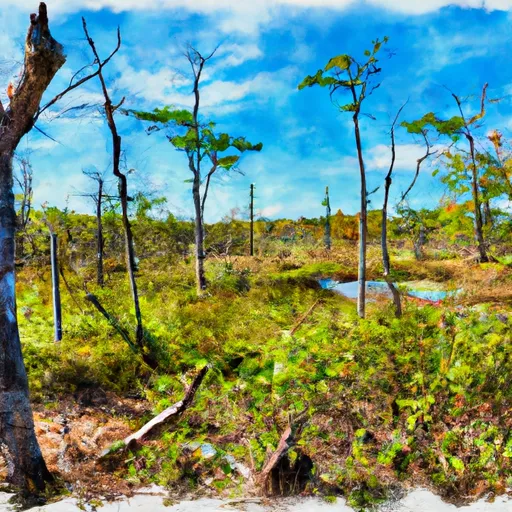
<p>Simpson Township Barrens is a unique ecological area containing several native plant communities such as limestone barrens, seeps, dry and dry-mesic upland forest, an intermittent creek drainage and support a rich diversity of plants. The limestone barrens communities are characterized by very dry, calcium rich soils that support a flora more commonly encountered on the tall grass prairies found north of the Shawnee National Forest. At the Simpson Township Barrens Ecological Area two limestone barrens are located within a matrix of dry and dry-mesic upland forest each with a southwestern aspect. The dry and dry-upland oak forests are dominated by post oaks (Quercus stellata), white oaks (Quercus alba) and black oaks (Quercus velutina). pignut hickory (Carya glabra), and mockernut hickory (Carya tomentosa) are also commonly encountered. Unlike the barrens community the forested matrix is characterized by sandstone cliffs, sandstone boulders and other sandstone rocks giving the soils a somewhat sandy consistency. The soils are acidic and support a flora completely different from the limestone barrens.</p>
Plan your visit down to the hour
Same weather feed Snoflo's iOS app uses -- updated continuously from NOAA / yr.no.
Next 5 days, hour by hour
Temperature line with weather symbols on top, snow + rain accumulation as columns, humidity as a dotted line.
5-day forecast table
Every 3 hours, broken out across temperature, snow, rain, humidity, and wind.
| Time | Condition | Temp (°F) | Snow (in) | Rain (in) | Humidity (%) | Wind (mps) | Wind dir |
|---|---|---|---|---|---|---|---|
| Loading detailed forecast… | |||||||
15-day temperature & precipitation
Daily temperatures, snow, and rain projected over the next two weeks.
Plan a longer trip
The closest parks, campgrounds, fishing spots, and other landmarks so a quick visit can grow into a full day.
Parks
- Wilderness Burden Falls
- Wilderness Bay Creek
- Dixon Springs State Park
- Vienna Community Park
- Wilderness Lusk Creek
- Deer Pond Nature Preserve
Responsible visitation & Leave No Trace
- Know before you go
- Check the operator's site (BLM, NPS, state agency, or private owner) for access rules, permits, and seasonal closures before driving out.
- Stay on trail
- Many points of interest sit in fragile ecosystems. Stick to marked paths to protect vegetation and prevent erosion.
- Respect wildlife
- Observe from a distance, never feed wildlife, and give nesting birds and denning mammals plenty of space.
- Pack it in, pack it out
- Take all trash, food scraps, and gear back with you. Remote sites often have no trash service.
- Leave what you find
- Don't take rocks, plants, fossils, or artifacts. Federal law protects cultural and natural resources on public land.
Set push alerts in the Snoflo app
Save Simpson Barrens Natural Area as a favorite, set a weather threshold (precipitation, freezing temperatures), and the iOS app will push the moment conditions cross.
About Simpson Barrens Natural Area
What is Simpson Barrens Natural Area?
A point of interest in Mississippi tracked by Snoflo -- typically a scenic landmark, named summit, monument, or viewpoint.
How fresh is the weather data?
The hourly forecast updates throughout the day from NOAA / yr.no public feeds.
When is the best time to visit?
Use the 15-day temperature & precipitation outlook on this page to pick a window with comfortable temperatures and low precipitation.
How do I get there?
Tap Directions in the hero above for Google Maps driving directions, or Open in map to center the Snoflo interactive map on the spot.
Can I get alerts when conditions change?
Yes -- alerts are managed in the Snoflo iOS app. Favorite this POI, set a threshold (temperature, precipitation), and you'll get a push the moment it crosses.
Other points of interest near here
Snoflo-tracked landmarks within driving distance of Simpson Barrens Natural Area.