
Picture Dam Reservoir Report
Nearby: Lake Jordan Dam Clarkes Dam
Last Updated: December 5, 2025
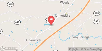
Picture Dam, located in Dinwiddie, Virginia, on Picture Branch, is a privately owned structure primarily used for irrigation purposes.
°F
°F
mph
Wind
%
Humidity
Summary
The dam, classified as an Earth dam, stands at a height of 19 feet and has a storage capacity of 567 acre-feet. The dam is state-regulated by the Department of Conservation and Recreation in Virginia, with inspections, permitting, and enforcement all conducted by the state regulatory agency.
Although the hazard potential of Picture Dam is currently listed as undetermined and its condition assessment is not rated, the structure has not undergone any recent modifications or assessments. Emergency action plans and risk management measures for the dam are also lacking information, indicating potential gaps in safety protocols. Despite these uncertainties, the dam serves a crucial role in providing irrigation water and recreational opportunities in the area.
With its location in a picturesque setting and its importance for water resource management, Picture Dam is an intriguing structure for water resource and climate enthusiasts to explore. The dam, under the jurisdiction of the Norfolk District of the US Army Corps of Engineers, presents an opportunity for further study and evaluation to ensure its continued safe operation and contribution to the local community.
Dam Height |
19 |
River Or Stream |
PICTURE BRANCH |
Primary Dam Type |
Earth |
Hydraulic Height |
19 |
Nid Storage |
567 |
Structural Height |
19 |
Hazard Potential |
Undetermined |
Nid Height |
19 |
Seasonal Comparison
Weather Forecast
Nearby Streamflow Levels
 Appomattox River At Matoaca
|
498cfs |
 Stony Creek Near Dinwiddie
|
32cfs |
 Nottoway River Near Stony Creek
|
302cfs |
 Nottoway River Near Rawlings
|
157cfs |
 Deep Creek Near Mannboro
|
96cfs |
 Appomattox River At Mattoax
|
309cfs |
Dam Data Reference
Condition Assessment
SatisfactoryNo existing or potential dam safety deficiencies are recognized. Acceptable performance is expected under all loading conditions (static, hydrologic, seismic) in accordance with the minimum applicable state or federal regulatory criteria or tolerable risk guidelines.
Fair
No existing dam safety deficiencies are recognized for normal operating conditions. Rare or extreme hydrologic and/or seismic events may result in a dam safety deficiency. Risk may be in the range to take further action. Note: Rare or extreme event is defined by the regulatory agency based on their minimum
Poor A dam safety deficiency is recognized for normal operating conditions which may realistically occur. Remedial action is necessary. POOR may also be used when uncertainties exist as to critical analysis parameters which identify a potential dam safety deficiency. Investigations and studies are necessary.
Unsatisfactory
A dam safety deficiency is recognized that requires immediate or emergency remedial action for problem resolution.
Not Rated
The dam has not been inspected, is not under state or federal jurisdiction, or has been inspected but, for whatever reason, has not been rated.
Not Available
Dams for which the condition assessment is restricted to approved government users.
Hazard Potential Classification
HighDams assigned the high hazard potential classification are those where failure or mis-operation will probably cause loss of human life.
Significant
Dams assigned the significant hazard potential classification are those dams where failure or mis-operation results in no probable loss of human life but can cause economic loss, environment damage, disruption of lifeline facilities, or impact other concerns. Significant hazard potential classification dams are often located in predominantly rural or agricultural areas but could be in areas with population and significant infrastructure.
Low
Dams assigned the low hazard potential classification are those where failure or mis-operation results in no probable loss of human life and low economic and/or environmental losses. Losses are principally limited to the owner's property.
Undetermined
Dams for which a downstream hazard potential has not been designated or is not provided.
Not Available
Dams for which the downstream hazard potential is restricted to approved government users.
 Picture Dam
 West End Park Fairgrounds
 Matoaca Park
 McKenzie Street Park
 Ettrick Park
 Cameron Field