


Cannelton Locks And Dam Reservoir Report
Last Updated: April 25, 2026
Nearby: Camp Koch Lake Dam Stroup Lake Dam
°F
°F
mph
Wind
%
Humidity
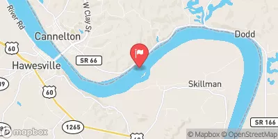
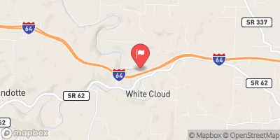
Cannelton Locks and Dam, located on the Ohio River in Kentucky, is a vital infrastructure managed by the US Army Corps of Engineers for navigation, recreation, and water supply purposes.
Summary
Completed in 1974, this concrete gravity dam stands 62 feet tall with a hydraulic height of 50 feet and a length of 2280 feet. With a storage capacity of 954,400 acre-feet, the dam serves a drainage area of 97,000 square miles, regulating a maximum discharge of 127,000 cubic feet per second.
The dam, equipped with two locks each 1200 feet long and 110 feet wide, plays a crucial role in managing flood risks in the region. USACE closely monitors the dam's condition, implements risk management measures, and collaborates with local emergency managers to ensure preparedness for any potential dam-related emergencies. Despite the dam's significant hazard potential, USACE's proactive approach and regular maintenance ensure the safety and functionality of Cannelton Locks and Dam for the surrounding communities.
As climate change continues to pose challenges, Cannelton Locks and Dam stands as a critical asset in water resource management. With a focus on risk assessment, emergency preparedness, and ongoing maintenance, USACE remains committed to safeguarding this essential infrastructure and the communities it serves along the Ohio River.
Regional Streamflow Levels
15-Day Long Term Forecast
Year Completed |
1974 |
Dam Length |
2280 |
River Or Stream |
OHIO RIVER |
Primary Dam Type |
Concrete |
Surface Area |
22760 |
Length Of Locks |
1200 |
Hydraulic Height |
50 |
Drainage Area |
97000 |
Nid Storage |
954400 |
Structural Height |
62 |
Outlet Gates |
Tainter (radial) - 12 |
Hazard Potential |
Significant |
Nid Height |
62 |
Seasonal Comparison
5-Day Hourly Forecast Detail
Dam Data Reference
Condition Assessment
SatisfactoryNo existing or potential dam safety deficiencies are recognized. Acceptable performance is expected under all loading conditions (static, hydrologic, seismic) in accordance with the minimum applicable state or federal regulatory criteria or tolerable risk guidelines.
Fair
No existing dam safety deficiencies are recognized for normal operating conditions. Rare or extreme hydrologic and/or seismic events may result in a dam safety deficiency. Risk may be in the range to take further action. Note: Rare or extreme event is defined by the regulatory agency based on their minimum
Poor A dam safety deficiency is recognized for normal operating conditions which may realistically occur. Remedial action is necessary. POOR may also be used when uncertainties exist as to critical analysis parameters which identify a potential dam safety deficiency. Investigations and studies are necessary.
Unsatisfactory
A dam safety deficiency is recognized that requires immediate or emergency remedial action for problem resolution.
Not Rated
The dam has not been inspected, is not under state or federal jurisdiction, or has been inspected but, for whatever reason, has not been rated.
Not Available
Dams for which the condition assessment is restricted to approved government users.
Hazard Potential Classification
HighDams assigned the high hazard potential classification are those where failure or mis-operation will probably cause loss of human life.
Significant
Dams assigned the significant hazard potential classification are those dams where failure or mis-operation results in no probable loss of human life but can cause economic loss, environment damage, disruption of lifeline facilities, or impact other concerns. Significant hazard potential classification dams are often located in predominantly rural or agricultural areas but could be in areas with population and significant infrastructure.
Low
Dams assigned the low hazard potential classification are those where failure or mis-operation results in no probable loss of human life and low economic and/or environmental losses. Losses are principally limited to the owner's property.
Undetermined
Dams for which a downstream hazard potential has not been designated or is not provided.
Not Available
Dams for which the downstream hazard potential is restricted to approved government users.
Area Campgrounds
| Location | Reservations | Toilets |
|---|---|---|
 Vastwood Park
|
||
 Vastwood Co Park
|
||
 German Ridge
|
||
 Saddle Lake Rec Area
|
||
 Yellowbank Creek - Yellowbank WMA
|
 SR 166 8699, Perry County