


Arkla Lake Dam Reservoir Report
Last Updated: April 28, 2026
°F
°F
mph
Wind
%
Humidity
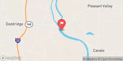
Arkla Lake Dam, located in Miller County, Arkansas, was completed in 1958 and serves as a recreational haven for water resource and climate enthusiasts.
Summary
The dam, primarily owned and operated by a private entity, stands at a height of 16 feet with a hydraulic height of 12 feet. It spans 650 feet in length and has a storage capacity of 132 acre-feet, providing ample water resources for various recreational activities. The dam is situated on State Line Creek-TR and is regulated solely by the state, with no federal oversight.
Despite its significant hazard potential, Arkla Lake Dam is currently rated as "Not Rated" in terms of condition assessment. The dam's emergency action plan status, risk assessment, and inundation maps remain unknown, suggesting potential gaps in risk management measures. With a surface area of 12.6 acres and a drainage area of 0.78 square miles, the dam's capacity for maximum discharge is 1800 cubic feet per second. While the dam's structural integrity remains unassessed, its purpose for recreation and its strategic location make it a valuable asset for water resource enthusiasts in the area.
Regional Streamflow Levels
 Red River At Spring Bank
|
9740cfs |
 Sulphur Rv Nr Texarkana
|
2030cfs |
 Big Cypress Ck Abv Sh 43 Nr Karnack
|
565cfs |
 Black Cypress Bayou At Jefferson
|
99cfs |
 Little Cypress Ck Nr Jefferson
|
141cfs |
 Bayou Dorcheat Near Springhill
|
22cfs |
15-Day Long Term Forecast
Year Completed |
1958 |
Dam Length |
650 |
Dam Height |
16 |
River Or Stream |
STATE LINE CREEK-TR |
Primary Dam Type |
Earth |
Surface Area |
12.6 |
Hydraulic Height |
12 |
Drainage Area |
0.78 |
Nid Storage |
132 |
Structural Height |
16 |
Hazard Potential |
Significant |
Nid Height |
16 |
Seasonal Comparison
5-Day Hourly Forecast Detail
Dam Data Reference
Condition Assessment
SatisfactoryNo existing or potential dam safety deficiencies are recognized. Acceptable performance is expected under all loading conditions (static, hydrologic, seismic) in accordance with the minimum applicable state or federal regulatory criteria or tolerable risk guidelines.
Fair
No existing dam safety deficiencies are recognized for normal operating conditions. Rare or extreme hydrologic and/or seismic events may result in a dam safety deficiency. Risk may be in the range to take further action. Note: Rare or extreme event is defined by the regulatory agency based on their minimum
Poor A dam safety deficiency is recognized for normal operating conditions which may realistically occur. Remedial action is necessary. POOR may also be used when uncertainties exist as to critical analysis parameters which identify a potential dam safety deficiency. Investigations and studies are necessary.
Unsatisfactory
A dam safety deficiency is recognized that requires immediate or emergency remedial action for problem resolution.
Not Rated
The dam has not been inspected, is not under state or federal jurisdiction, or has been inspected but, for whatever reason, has not been rated.
Not Available
Dams for which the condition assessment is restricted to approved government users.
Hazard Potential Classification
HighDams assigned the high hazard potential classification are those where failure or mis-operation will probably cause loss of human life.
Significant
Dams assigned the significant hazard potential classification are those dams where failure or mis-operation results in no probable loss of human life but can cause economic loss, environment damage, disruption of lifeline facilities, or impact other concerns. Significant hazard potential classification dams are often located in predominantly rural or agricultural areas but could be in areas with population and significant infrastructure.
Low
Dams assigned the low hazard potential classification are those where failure or mis-operation results in no probable loss of human life and low economic and/or environmental losses. Losses are principally limited to the owner's property.
Undetermined
Dams for which a downstream hazard potential has not been designated or is not provided.
Not Available
Dams for which the downstream hazard potential is restricted to approved government users.
 AR 160 Miller County