


Bill Strahand Lake Dam Reservoir Report
Last Updated: April 21, 2026
°F
°F
mph
Wind
%
Humidity
Bill Strahand Lake Dam, located in Pearl River, Mississippi, is a privately owned earth dam built in 1968 for recreational purposes.
Summary
Standing at a height of 12 feet, the dam serves as a barrier on TR- CHINQUIPIN CREEK, with a storage capacity of 135 acre-feet. Designed by USDA NRCS, the dam falls under the regulatory oversight of the Mississippi Department of Environmental Quality, ensuring compliance with state regulations for inspection, permitting, and enforcement.
Despite being categorized with an "Undetermined" hazard potential and a "Moderate (3)" risk assessment, the condition of Bill Strahand Lake Dam is currently listed as "Not Rated." The dam features an uncontrolled spillway and outlet gates, with no associated locks. While the dam's emergency action plan status and risk management measures are not specified in the data, the presence of regulatory oversight and state jurisdiction suggests a commitment to ensuring the safety and integrity of the structure for both recreational and environmental purposes.
Water resource and climate enthusiasts interested in the intersection of dam infrastructure and environmental conservation may find Bill Strahand Lake Dam to be a compelling case study. With its unique design elements, regulatory framework, and risk assessment considerations, this dam serves as a focal point for understanding the balance between human recreation and natural resource management in the Mississippi region. As efforts to address climate change and water resource sustainability continue to evolve, the management and maintenance of dams like Bill Strahand Lake Dam will play a crucial role in ensuring the resilience of water systems in the face of environmental challenges.
Regional Streamflow Levels
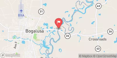 Pearl River Near Bogalusa
|
2170cfs |
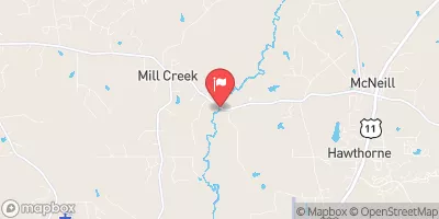 West Hobolochitto Creek Nr Mcneill
|
34cfs |
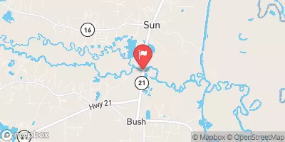 Bogue Chitto River Near Bush
|
744cfs |
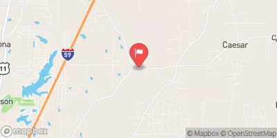 East Hobolochitto Creek Nr Caesar
|
18cfs |
 Tchefuncta River Near Folsom
|
59cfs |
 Pearl River Nr Columbia
|
1400cfs |
15-Day Long Term Forecast
Year Completed |
1968 |
Dam Height |
12 |
River Or Stream |
TR- CHINQUIPIN CREEK |
Primary Dam Type |
Earth |
Nid Storage |
135 |
Outlet Gates |
Uncontrolled |
Hazard Potential |
Undetermined |
Foundations |
Soil |
Nid Height |
12 |
Seasonal Comparison
5-Day Hourly Forecast Detail
Dam Data Reference
Condition Assessment
SatisfactoryNo existing or potential dam safety deficiencies are recognized. Acceptable performance is expected under all loading conditions (static, hydrologic, seismic) in accordance with the minimum applicable state or federal regulatory criteria or tolerable risk guidelines.
Fair
No existing dam safety deficiencies are recognized for normal operating conditions. Rare or extreme hydrologic and/or seismic events may result in a dam safety deficiency. Risk may be in the range to take further action. Note: Rare or extreme event is defined by the regulatory agency based on their minimum
Poor A dam safety deficiency is recognized for normal operating conditions which may realistically occur. Remedial action is necessary. POOR may also be used when uncertainties exist as to critical analysis parameters which identify a potential dam safety deficiency. Investigations and studies are necessary.
Unsatisfactory
A dam safety deficiency is recognized that requires immediate or emergency remedial action for problem resolution.
Not Rated
The dam has not been inspected, is not under state or federal jurisdiction, or has been inspected but, for whatever reason, has not been rated.
Not Available
Dams for which the condition assessment is restricted to approved government users.
Hazard Potential Classification
HighDams assigned the high hazard potential classification are those where failure or mis-operation will probably cause loss of human life.
Significant
Dams assigned the significant hazard potential classification are those dams where failure or mis-operation results in no probable loss of human life but can cause economic loss, environment damage, disruption of lifeline facilities, or impact other concerns. Significant hazard potential classification dams are often located in predominantly rural or agricultural areas but could be in areas with population and significant infrastructure.
Low
Dams assigned the low hazard potential classification are those where failure or mis-operation results in no probable loss of human life and low economic and/or environmental losses. Losses are principally limited to the owner's property.
Undetermined
Dams for which a downstream hazard potential has not been designated or is not provided.
Not Available
Dams for which the downstream hazard potential is restricted to approved government users.