


Bishop Dam Reservoir Report
Last Updated: April 28, 2026
°F
°F
mph
Wind
%
Humidity
Bishop Dam, located in Southampton, Virginia, is a state-regulated structure on the Meherrin River primarily used for fire protection, stock, and small fish pond purposes.
Summary
The dam, with a height of 7 feet and a storage capacity of 126 acre-feet, is classified as an earth dam. While its hazard potential is currently undetermined and its condition has not been rated, the Department of Conservation and Recreation in Virginia oversees the regulation, inspection, and enforcement of this dam to ensure its safety and functionality.
Although specific details about the construction date, spillway type, and inspection history are not provided, Bishop Dam is a vital component of the water resource infrastructure in the area. With the dam's strategic location on the Meherrin River and its capacity to store water for various purposes, it serves as a key asset for maintaining water quality, supporting local wildlife, and protecting against fire hazards. As climate change continues to impact water resources, the management and maintenance of dams like Bishop Dam become increasingly important for ensuring the resilience of water systems in the face of changing environmental conditions.
As water resource and climate enthusiasts, understanding the role of Bishop Dam in the broader context of water management and climate adaptation efforts is crucial. By recognizing the importance of state-regulated structures like Bishop Dam in safeguarding water resources and ecosystems, we can work towards sustainable practices that mitigate the impacts of climate change and ensure the availability of clean water for future generations. Through continued monitoring, regulation, and investment in infrastructure like Bishop Dam, we can enhance the resilience of our water systems and protect against the growing challenges posed by a changing climate.
Regional Streamflow Levels
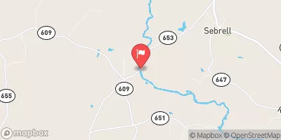 Nottoway River Near Sebrell
|
174cfs |
 Potecasi Creek Near Union
|
8cfs |
 Meherrin River At Emporia
|
115cfs |
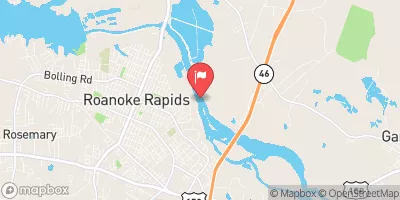 Roanoke River At Roanoke Rapids
|
2980cfs |
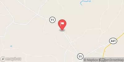
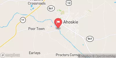 Ahoskie Creek At Ahoskie
|
7cfs |
 Blackwater River Near Franklin
|
25cfs |
15-Day Long Term Forecast
Dam Height |
7 |
River Or Stream |
TR-MEHERRIN RIVER |
Hydraulic Height |
7 |
Nid Storage |
126 |
Structural Height |
7 |
Hazard Potential |
Undetermined |
Nid Height |
7 |
Seasonal Comparison
5-Day Hourly Forecast Detail
Dam Data Reference
Condition Assessment
SatisfactoryNo existing or potential dam safety deficiencies are recognized. Acceptable performance is expected under all loading conditions (static, hydrologic, seismic) in accordance with the minimum applicable state or federal regulatory criteria or tolerable risk guidelines.
Fair
No existing dam safety deficiencies are recognized for normal operating conditions. Rare or extreme hydrologic and/or seismic events may result in a dam safety deficiency. Risk may be in the range to take further action. Note: Rare or extreme event is defined by the regulatory agency based on their minimum
Poor A dam safety deficiency is recognized for normal operating conditions which may realistically occur. Remedial action is necessary. POOR may also be used when uncertainties exist as to critical analysis parameters which identify a potential dam safety deficiency. Investigations and studies are necessary.
Unsatisfactory
A dam safety deficiency is recognized that requires immediate or emergency remedial action for problem resolution.
Not Rated
The dam has not been inspected, is not under state or federal jurisdiction, or has been inspected but, for whatever reason, has not been rated.
Not Available
Dams for which the condition assessment is restricted to approved government users.
Hazard Potential Classification
HighDams assigned the high hazard potential classification are those where failure or mis-operation will probably cause loss of human life.
Significant
Dams assigned the significant hazard potential classification are those dams where failure or mis-operation results in no probable loss of human life but can cause economic loss, environment damage, disruption of lifeline facilities, or impact other concerns. Significant hazard potential classification dams are often located in predominantly rural or agricultural areas but could be in areas with population and significant infrastructure.
Low
Dams assigned the low hazard potential classification are those where failure or mis-operation results in no probable loss of human life and low economic and/or environmental losses. Losses are principally limited to the owner's property.
Undetermined
Dams for which a downstream hazard potential has not been designated or is not provided.
Not Available
Dams for which the downstream hazard potential is restricted to approved government users.