San Francisco Bay Trail, Oakland Boat Launch
Community Reviews
Been here? Share the conditions.
Reviews, ratings & photos are added in the free Snoflo iOS app — rate a spot, tag the conditions, and your visit is verified by location. Add or manage your reviews from the app.
San Francisco Bay Trail, Oakland
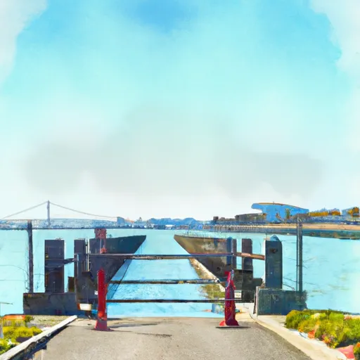
According to the official website of the East Bay Regional Park District, which manages the Martin Luther King Jr. Regional Shoreline Park, the boat ramp is currently open from dawn to dusk. The website also states that the park is open for day use only, and overnight camping is not allowed.
As for the type of watercraft permitted on the water, the website states that "non-motorized boats are generally allowed in the park," including canoes, kayaks, and rowboats. However, motorized boats are not allowed within the park except for authorized vessels used for park operations and emergencies.
In summary, the San Francisco Bay Trail boat ramp in Oakland, California is a public concrete ramp that provides access to the San Francisco Bay. It is approximately 20 feet wide and suitable for small boats, canoes, and kayaks. The ramp is located within the Martin Luther King Jr. Regional Shoreline Park, which allows non-motorized boats such as canoes, kayaks, and rowboats on the water.
Plan your launch down to the hour
Same weather feed Snoflo's iOS app uses -- updated continuously from NOAA / yr.no.
Next 5 days, hour by hour
Temperature line with weather symbols on top, snow + rain accumulation as columns, humidity as a dotted line.
5-day forecast table
Every 3 hours, broken out across temperature, snow, rain, humidity, and wind.
| Time | Condition | Temp (°F) | Snow (in) | Rain (in) | Humidity (%) | Wind (mps) | Wind dir |
|---|---|---|---|---|---|---|---|
| Loading detailed forecast… | |||||||
15-day temperature & precipitation
Daily temperatures, snow, and rain projected over the next two weeks.
Area streamflow levels
USGS streamgauges around San Francisco Bay Trail, Oakland -- the same readings that determine whether your launch is safe and your boat is the right craft.
| Streamgauge | Discharge | View |
|---|---|---|
| San Lorenzo C A San Lorenzo Ca | 2 cfs | → |
| Cull C Ab Cull C Res Nr Castro Valley Ca | · | → |
| Castro Valley C A Hayward Ca | 0 cfs | → |
| San Lorenzo C A Hayward Ca | 1 cfs | → |
| Crow C Nr Hayward Ca | 0 cfs | → |
| San Lorenzo C Ab Don Castro Res Nr Castro V Ca | 0 cfs | → |
Plan a longer trip
The closest paddle runs, fishing spots, and other boat launches so you can extend a day on the water.
River runs
- Headwaters To Mouth
- Headwaters To Ends One Quarter Mile South Of Bear Valley Road Bridge Segment 1: Ends 1/4 Mile South Of Bear Valley Road Bridge Segment 2: Caltrans Corporation Yard At Point Reyes Staton.
- Olema Ranch Campground To Caltrans Corporation Yard At Point Reyes Station
Nearby fishing
Boating safety & etiquette
- Check the conditions before you launch
- Use the streamflow numbers, weather, and wind forecast on this page. High-cfs whitewater requires whitewater-specific craft and skill.
- Wear your life jacket
- Statistically the single biggest survival factor in a boating incident. State law often requires one per passenger.
- File a float plan
- Tell someone on shore your put-in, take-out, and expected return time. Especially for multi-day or remote trips.
- Yield at the ramp
- Prep gear in the parking lot, not on the ramp. Launch and clear quickly so others can use the lane.
- Clean, drain, dry
- Inspect, clean, drain and dry your boat between waters to prevent the spread of aquatic invasive species.
Set push alerts in the Snoflo app
Save San Francisco Bay Trail, Oakland as a favorite, set a discharge threshold or a wind/precipitation alert, and the iOS app will push the moment conditions cross.
About San Francisco Bay Trail, Oakland
Can I launch a motorboat here?
Most Snoflo-tracked launches support motorboats; check the operator for any horsepower restrictions, paddle-only zones, or seasonal closures.
How fresh is the streamflow data?
USGS streamgauges report continuously (every 15 minutes); the table on this page pulls the latest reading at page load.
Is there a fee?
Many federal and state boat launches charge a day-use fee. Check the operator's site before driving out.
What boat is right for these conditions?
Use the nearby streamflow numbers and river-run panel on this page to gauge current conditions. Wider, slower water is friendly for casual paddling and powerboats; high-cfs whitewater requires whitewater-specific craft and skill.
Can I get alerts when conditions change?
Yes -- alerts are managed in the Snoflo iOS app. Favorite this launch, set a threshold (discharge, wind), and you'll get a push the moment it crosses.
Other launches near here
Snoflo-tracked boat launches within driving distance of San Francisco Bay Trail, Oakland.