Frances Avenue 5698, New Port Richey Boat Launch
Community Reviews
Been here? Share the conditions.
Reviews, ratings & photos are added in the free Snoflo iOS app — rate a spot, tag the conditions, and your visit is verified by location. Add or manage your reviews from the app.
Frances Avenue 5698, New Port Richey
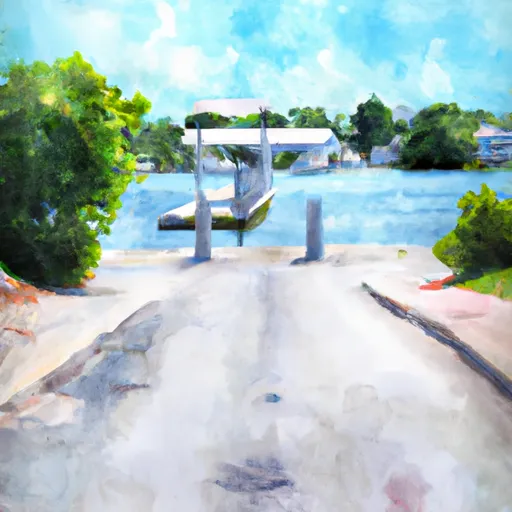
This boat ramp is a public facility that provides access to the Gulf of Mexico. It is situated at the end of Frances Avenue, which is a small road that runs north-south parallel to the shoreline.
According to the Pasco County website, the Frances Avenue boat ramp is 20 feet wide and has two launch lanes. There is also a floating dock available for tying up boats.
The water body that the ramp services is the Gulf of Mexico, which is a large body of saltwater that borders the western coast of Florida. The Gulf of Mexico is known for its diverse marine life and recreational opportunities such as fishing, boating, and swimming.
In terms of permitted craft, the Pasco County website states that the Frances Avenue boat ramp can accommodate boats up to 26 feet in length. Additionally, the website notes that the ramp can be used for jet skis, kayaks, and other small watercraft. It is important to note that boaters should always adhere to local regulations and safety guidelines when using any waterway.
Overall, the Frances Avenue 5698 boat ramp appears to be a well-maintained public facility that provides convenient access to the Gulf of Mexico for a range of watercraft.
Plan your launch down to the hour
Same weather feed Snoflo's iOS app uses -- updated continuously from NOAA / yr.no.
Next 5 days, hour by hour
Temperature line with weather symbols on top, snow + rain accumulation as columns, humidity as a dotted line.
5-day forecast table
Every 3 hours, broken out across temperature, snow, rain, humidity, and wind.
| Time | Condition | Temp (°F) | Snow (in) | Rain (in) | Humidity (%) | Wind (mps) | Wind dir |
|---|---|---|---|---|---|---|---|
| Loading detailed forecast… | |||||||
15-day temperature & precipitation
Daily temperatures, snow, and rain projected over the next two weeks.
Area streamflow levels
USGS streamgauges around Frances Avenue 5698, New Port Richey -- the same readings that determine whether your launch is safe and your boat is the right craft.
| Streamgauge | Discharge | View |
|---|---|---|
| Anclote River Near Elfers Fl | 3 cfs | → |
| Pithlachascotee River Near New Port Richey Fl | · | → |
| Anclote River Near Odessa Fl | · | → |
| Brooker Creek Near Lake Fern Fl | · | → |
| Pithlachascotee R Bl Suncoast Pkwy Nr Fivay Jct Fl | · | → |
| Brooker Creek Near Tarpon Springs Fl | 0 cfs | → |
Plan a longer trip
The closest paddle runs, fishing spots, and other boat launches so you can extend a day on the water.
Boating safety & etiquette
- Check the conditions before you launch
- Use the streamflow numbers, weather, and wind forecast on this page. High-cfs whitewater requires whitewater-specific craft and skill.
- Wear your life jacket
- Statistically the single biggest survival factor in a boating incident. State law often requires one per passenger.
- File a float plan
- Tell someone on shore your put-in, take-out, and expected return time. Especially for multi-day or remote trips.
- Yield at the ramp
- Prep gear in the parking lot, not on the ramp. Launch and clear quickly so others can use the lane.
- Clean, drain, dry
- Inspect, clean, drain and dry your boat between waters to prevent the spread of aquatic invasive species.
Set push alerts in the Snoflo app
Save Frances Avenue 5698, New Port Richey as a favorite, set a discharge threshold or a wind/precipitation alert, and the iOS app will push the moment conditions cross.
About Frances Avenue 5698, New Port Richey
Can I launch a motorboat here?
Most Snoflo-tracked launches support motorboats; check the operator for any horsepower restrictions, paddle-only zones, or seasonal closures.
How fresh is the streamflow data?
USGS streamgauges report continuously (every 15 minutes); the table on this page pulls the latest reading at page load.
Is there a fee?
Many federal and state boat launches charge a day-use fee. Check the operator's site before driving out.
What boat is right for these conditions?
Use the nearby streamflow numbers and river-run panel on this page to gauge current conditions. Wider, slower water is friendly for casual paddling and powerboats; high-cfs whitewater requires whitewater-specific craft and skill.
Can I get alerts when conditions change?
Yes -- alerts are managed in the Snoflo iOS app. Favorite this launch, set a threshold (discharge, wind), and you'll get a push the moment it crosses.
Other launches near here
Snoflo-tracked boat launches within driving distance of Frances Avenue 5698, New Port Richey.