Lake Monroe Wayside Boat Ramp Boat Launch
Community Reviews
Been here? Share the conditions.
Reviews, ratings & photos are added in the free Snoflo iOS app — rate a spot, tag the conditions, and your visit is verified by location. Add or manage your reviews from the app.
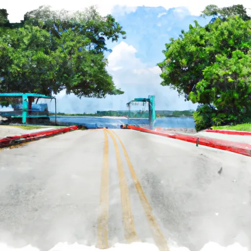
Lake Monroe Wayside Boat Ramp
The Lake Monroe Wayside Boat Ramp is a public boat ramp that is open 24 hours a day, year-round. It is equipped with amenities such as restrooms, parking, and picnic areas, making it a popular destination for families and friends looking to enjoy a day on the water.
Lake Monroe is known for its diverse population of fish, including largemouth bass, catfish, and crappie. The lake also offers opportunities for water skiing, wakeboarding, and other water sports. The body of water is open to all types of watercraft, including motorized boats, kayaks, and canoes.
According to the latest information available, the Lake Monroe Wayside Boat Ramp is well-maintained and provides easy access to Lake Monroe. Visitors can expect clean facilities, ample parking, and a smooth ramp surface. The Florida Fish and Wildlife Conservation Commission regularly monitors the lake's water quality to ensure it is safe for recreational activities.
Plan your launch down to the hour
Same weather feed Snoflo's iOS app uses -- updated continuously from NOAA / yr.no.
Next 5 days, hour by hour
Temperature line with weather symbols on top, snow + rain accumulation as columns, humidity as a dotted line.
5-day forecast table
Every 3 hours, broken out across temperature, snow, rain, humidity, and wind.
| Time | Condition | Temp (°F) | Snow (in) | Rain (in) | Humidity (%) | Wind (mps) | Wind dir |
|---|---|---|---|---|---|---|---|
| Loading detailed forecast… | |||||||
15-day temperature & precipitation
Daily temperatures, snow, and rain projected over the next two weeks.
Area streamflow levels
USGS streamgauges around Lake Monroe Wayside Boat Ramp -- the same readings that determine whether your launch is safe and your boat is the right craft.
| Streamgauge | Discharge | View |
|---|---|---|
| St. Johns River Nr Sanford | 1,920 cfs | → |
| Wekiva River Nr Sanford | 169 cfs | → |
| Soldier Creek Nr Longwood | 9 cfs | → |
| Lake Jesup Outlet Nr Sanford | 994 cfs | → |
| Gee Creek Nr Longwood | 14 cfs | → |
| Blackwater Creek Near Cassia | 3 cfs | → |
Plan a longer trip
The closest paddle runs, fishing spots, and other boat launches so you can extend a day on the water.
River runs
- Segment B--Alexander Springs Wilderness Boundary To Confluence With St. Johns River
- Segment A--Mouth Of Spring On Ocala Nf To Alexander Springs Wilderness Boundary
- Segment B--Bridge On Sh 19 To Confluence With Lake George
- Segment A--Mouth Of Spring On Ocala Nf (At Juniper Springs Wilderness) To Bridge On Sh 19 (At Wilderness Boundary)
Nearby fishing
Boating safety & etiquette
- Check the conditions before you launch
- Use the streamflow numbers, weather, and wind forecast on this page. High-cfs whitewater requires whitewater-specific craft and skill.
- Wear your life jacket
- Statistically the single biggest survival factor in a boating incident. State law often requires one per passenger.
- File a float plan
- Tell someone on shore your put-in, take-out, and expected return time. Especially for multi-day or remote trips.
- Yield at the ramp
- Prep gear in the parking lot, not on the ramp. Launch and clear quickly so others can use the lane.
- Clean, drain, dry
- Inspect, clean, drain and dry your boat between waters to prevent the spread of aquatic invasive species.
Set push alerts in the Snoflo app
Save Lake Monroe Wayside Boat Ramp as a favorite, set a discharge threshold or a wind/precipitation alert, and the iOS app will push the moment conditions cross.
About Lake Monroe Wayside Boat Ramp
Can I launch a motorboat here?
Most Snoflo-tracked launches support motorboats; check the operator for any horsepower restrictions, paddle-only zones, or seasonal closures.
How fresh is the streamflow data?
USGS streamgauges report continuously (every 15 minutes); the table on this page pulls the latest reading at page load.
Is there a fee?
Many federal and state boat launches charge a day-use fee. Check the operator's site before driving out.
What boat is right for these conditions?
Use the nearby streamflow numbers and river-run panel on this page to gauge current conditions. Wider, slower water is friendly for casual paddling and powerboats; high-cfs whitewater requires whitewater-specific craft and skill.
Can I get alerts when conditions change?
Yes -- alerts are managed in the Snoflo iOS app. Favorite this launch, set a threshold (discharge, wind), and you'll get a push the moment it crosses.
Other launches near here
Snoflo-tracked boat launches within driving distance of Lake Monroe Wayside Boat Ramp.