Southeast Evergreen Drive 358, Lake City Boat Launch
Community Reviews
Been here? Share the conditions.
Reviews, ratings & photos are added in the free Snoflo iOS app — rate a spot, tag the conditions, and your visit is verified by location. Add or manage your reviews from the app.
Southeast Evergreen Drive 358, Lake City
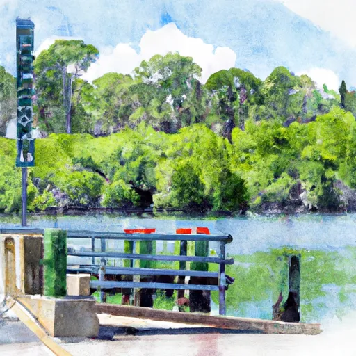
According to the latest available information, the Southeast Evergreen Drive 358 boat ramp in Lake City, Florida is a public, single lane concrete ramp with a parking area for vehicles and trailers. The ramp is approximately 20 feet wide and can accommodate small to medium-sized boats.
This boat ramp services the nearby Alligator Lake, which covers an area of approximately 3,000 acres. Alligator Lake is a popular fishing destination and is home to a variety of fish species, including largemouth bass, bluegill, and catfish.
The Florida Fish and Wildlife Conservation Commission regulates the use of boats on Alligator Lake. According to their rules and regulations, all boats must be equipped with at least one Personal Flotation Device (PFD) for each person on board, and all vessels must comply with state and federal boating laws and regulations.
In addition, the use of gas-powered motors is allowed on Alligator Lake, but there are restrictions on the size and horsepower of the motor. The maximum horsepower allowed on the lake is 10 horsepower, and all vessels must comply with local noise ordinances.
Overall, the Southeast Evergreen Drive 358 boat ramp is a popular and accessible entry point for boaters looking to explore Alligator Lake in Lake City, Florida.
Plan your launch down to the hour
Same weather feed Snoflo's iOS app uses -- updated continuously from NOAA / yr.no.
Next 5 days, hour by hour
Temperature line with weather symbols on top, snow + rain accumulation as columns, humidity as a dotted line.
5-day forecast table
Every 3 hours, broken out across temperature, snow, rain, humidity, and wind.
| Time | Condition | Temp (°F) | Snow (in) | Rain (in) | Humidity (%) | Wind (mps) | Wind dir |
|---|---|---|---|---|---|---|---|
| Loading detailed forecast… | |||||||
15-day temperature & precipitation
Daily temperatures, snow, and rain projected over the next two weeks.
Area streamflow levels
USGS streamgauges around Southeast Evergreen Drive 358, Lake City -- the same readings that determine whether your launch is safe and your boat is the right craft.
| Streamgauge | Discharge | View |
|---|---|---|
| Suwannee River At White Springs | 75 cfs | → |
| Santa Fe River At O'Leno State Park Fla | 30 cfs | → |
| Ichetucknee R @ Hwy27 Nr Hildreth | 221 cfs | → |
| Santa Fe River At River Rise Nr High Springs | 17 cfs | → |
| Santa Fe River At Worthington Springs | · | → |
| Santa Fe River Nr Hildreth Fla | 902 cfs | → |
Plan a longer trip
The closest paddle runs, fishing spots, and other boat launches so you can extend a day on the water.
River runs
- Ichetucknee Headspring To The First Powerline Crossing Over Ichetucknee River
- The First Powerline Crossing The Ichetuckee River To The Confluence With The Santa Fe River, Down The Santa Fe River To The Suwannee River
- The Little River Springs At River Mile 81 To The Mouth Of The River At The Gulf Of Mexico
- The Confluence Of The North Prong And Middle Prong To Trader's Hill
Nearby fishing
Boating safety & etiquette
- Check the conditions before you launch
- Use the streamflow numbers, weather, and wind forecast on this page. High-cfs whitewater requires whitewater-specific craft and skill.
- Wear your life jacket
- Statistically the single biggest survival factor in a boating incident. State law often requires one per passenger.
- File a float plan
- Tell someone on shore your put-in, take-out, and expected return time. Especially for multi-day or remote trips.
- Yield at the ramp
- Prep gear in the parking lot, not on the ramp. Launch and clear quickly so others can use the lane.
- Clean, drain, dry
- Inspect, clean, drain and dry your boat between waters to prevent the spread of aquatic invasive species.
Set push alerts in the Snoflo app
Save Southeast Evergreen Drive 358, Lake City as a favorite, set a discharge threshold or a wind/precipitation alert, and the iOS app will push the moment conditions cross.
About Southeast Evergreen Drive 358, Lake City
Can I launch a motorboat here?
Most Snoflo-tracked launches support motorboats; check the operator for any horsepower restrictions, paddle-only zones, or seasonal closures.
How fresh is the streamflow data?
USGS streamgauges report continuously (every 15 minutes); the table on this page pulls the latest reading at page load.
Is there a fee?
Many federal and state boat launches charge a day-use fee. Check the operator's site before driving out.
What boat is right for these conditions?
Use the nearby streamflow numbers and river-run panel on this page to gauge current conditions. Wider, slower water is friendly for casual paddling and powerboats; high-cfs whitewater requires whitewater-specific craft and skill.
Can I get alerts when conditions change?
Yes -- alerts are managed in the Snoflo iOS app. Favorite this launch, set a threshold (discharge, wind), and you'll get a push the moment it crosses.
Other launches near here
Snoflo-tracked boat launches within driving distance of Southeast Evergreen Drive 358, Lake City.