Tenoroc Mine Road, Lakeland Boat Launch
Community Reviews
Been here? Share the conditions.
Reviews, ratings & photos are added in the free Snoflo iOS app — rate a spot, tag the conditions, and your visit is verified by location. Add or manage your reviews from the app.
Tenoroc Mine Road, Lakeland
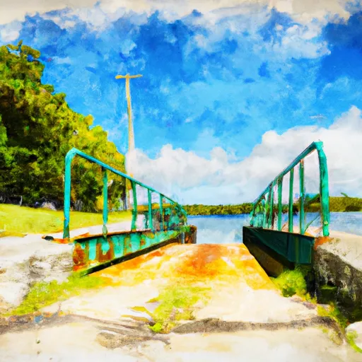
The width of the boat ramp is approximately 10 feet, which is wide enough to accommodate most small boats and watercraft. However, it may not be suitable for larger boats, particularly those with a significant beam or draft.
The Tenoroc Mine Road boat ramp services Lake Parker, which is a popular fishing and boating destination in Lakeland. This lake is approximately 2,400 acres in size and has an average depth of 10 feet. It is home to a variety of fish species, including largemouth bass, bluegill, crappie, and catfish.
The kind of craft that are permitted on Lake Parker includes canoes, kayaks, small boats, and other watercraft that are less than 16 feet in length. Larger boats may be permitted but are subject to certain restrictions and regulations.
In conclusion, the Tenoroc Mine Road boat ramp is a small concrete ramp that provides access to Lake Parker in Lakeland, Florida. It is suitable for small boats and watercraft and services a variety of fish species. The ramp is approximately 10 feet wide and may not be suitable for larger boats.
Plan your launch down to the hour
Same weather feed Snoflo's iOS app uses -- updated continuously from NOAA / yr.no.
Next 5 days, hour by hour
Temperature line with weather symbols on top, snow + rain accumulation as columns, humidity as a dotted line.
5-day forecast table
Every 3 hours, broken out across temperature, snow, rain, humidity, and wind.
| Time | Condition | Temp (°F) | Snow (in) | Rain (in) | Humidity (%) | Wind (mps) | Wind dir |
|---|---|---|---|---|---|---|---|
| Loading detailed forecast… | |||||||
15-day temperature & precipitation
Daily temperatures, snow, and rain projected over the next two weeks.
Area streamflow levels
USGS streamgauges around Tenoroc Mine Road, Lakeland -- the same readings that determine whether your launch is safe and your boat is the right craft.
| Streamgauge | Discharge | View |
|---|---|---|
| Saddle Creek At St.Hwy 542 Near Lakeland Fl | 16 cfs | → |
| Lake Parker Outlet At Lakeland Fl | 1 cfs | → |
| Saddle Creek At State Hwy 570 Near Eaton Park Fl | 25 cfs | → |
| Lake Lena Run Near Auburndale Fl | 15 cfs | → |
| Banana-Hancock Canal Nr Highland City | 9 cfs | → |
| Fox Branch Near Socrum | 9 cfs | → |
Plan a longer trip
The closest paddle runs, fishing spots, and other boat launches so you can extend a day on the water.
Boating safety & etiquette
- Check the conditions before you launch
- Use the streamflow numbers, weather, and wind forecast on this page. High-cfs whitewater requires whitewater-specific craft and skill.
- Wear your life jacket
- Statistically the single biggest survival factor in a boating incident. State law often requires one per passenger.
- File a float plan
- Tell someone on shore your put-in, take-out, and expected return time. Especially for multi-day or remote trips.
- Yield at the ramp
- Prep gear in the parking lot, not on the ramp. Launch and clear quickly so others can use the lane.
- Clean, drain, dry
- Inspect, clean, drain and dry your boat between waters to prevent the spread of aquatic invasive species.
Set push alerts in the Snoflo app
Save Tenoroc Mine Road, Lakeland as a favorite, set a discharge threshold or a wind/precipitation alert, and the iOS app will push the moment conditions cross.
About Tenoroc Mine Road, Lakeland
Can I launch a motorboat here?
Most Snoflo-tracked launches support motorboats; check the operator for any horsepower restrictions, paddle-only zones, or seasonal closures.
How fresh is the streamflow data?
USGS streamgauges report continuously (every 15 minutes); the table on this page pulls the latest reading at page load.
Is there a fee?
Many federal and state boat launches charge a day-use fee. Check the operator's site before driving out.
What boat is right for these conditions?
Use the nearby streamflow numbers and river-run panel on this page to gauge current conditions. Wider, slower water is friendly for casual paddling and powerboats; high-cfs whitewater requires whitewater-specific craft and skill.
Can I get alerts when conditions change?
Yes -- alerts are managed in the Snoflo iOS app. Favorite this launch, set a threshold (discharge, wind), and you'll get a push the moment it crosses.
Other launches near here
Snoflo-tracked boat launches within driving distance of Tenoroc Mine Road, Lakeland.