Water Street 4565, Milton Boat Launch
Community Reviews
Been here? Share the conditions.
Reviews, ratings & photos are added in the free Snoflo iOS app — rate a spot, tag the conditions, and your visit is verified by location. Add or manage your reviews from the app.
Water Street 4565, Milton
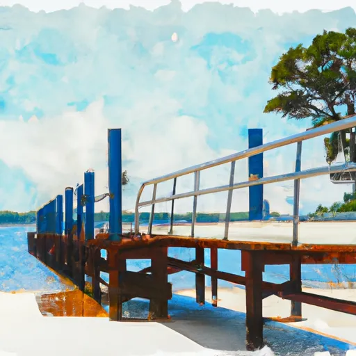
It is not clear what kind of boat ramp it is, but some online sources indicate that it is a public boat ramp. Additionally, the boat ramp is said to have two lanes, making it suitable for launching and retrieving boats of different sizes.
As for the width of the boat ramp, there is no available information that can verify its exact measurement. However, some sources suggest that it is wide enough to accommodate trailers and easily maneuver boats in and out of the water.
The boat ramp services the Blackwater River, which is a popular destination for boaters and anglers in the area. The Blackwater River is a navigable waterway that flows through the Blackwater State Forest and empties into Blackwater Bay.
The kind of craft permitted on the water depends on the regulations of the Blackwater River and Blackwater Bay. Generally, both water bodies allow motorized watercraft, such as powerboats, jet skis, and pontoon boats. However, some areas may have restrictions on the size and speed of boats allowed on the water, so it's best to check with the local authorities before launching any watercraft.
In summary, the Water Street 4565 boat ramp is a public boat ramp located in Milton, Florida, with two lanes suitable for launching and retrieving boats of different sizes. It services the Blackwater River, a navigable waterway that allows motorized watercraft, including powerboats, jet skis, and pontoon boats, with possible restrictions on size and speed.
Plan your launch down to the hour
Same weather feed Snoflo's iOS app uses -- updated continuously from NOAA / yr.no.
Next 5 days, hour by hour
Temperature line with weather symbols on top, snow + rain accumulation as columns, humidity as a dotted line.
5-day forecast table
Every 3 hours, broken out across temperature, snow, rain, humidity, and wind.
| Time | Condition | Temp (°F) | Snow (in) | Rain (in) | Humidity (%) | Wind (mps) | Wind dir |
|---|---|---|---|---|---|---|---|
| Loading detailed forecast… | |||||||
15-day temperature & precipitation
Daily temperatures, snow, and rain projected over the next two weeks.
Area streamflow levels
USGS streamgauges around Water Street 4565, Milton -- the same readings that determine whether your launch is safe and your boat is the right craft.
| Streamgauge | Discharge | View |
|---|---|---|
| Yellow River Nr Milton | 1,630 cfs | → |
| Big Coldwater Creek Nr Milton | 279 cfs | → |
| Escambia River Nr Molino | 3,750 cfs | → |
| Bayou Marcus Creek Nr Pensacola | 11 cfs | → |
| Elevenmile Creek Near Pensacola | 22 cfs | → |
| Blackwater River Nr Baker | 120 cfs | → |
Plan a longer trip
The closest paddle runs, fishing spots, and other boat launches so you can extend a day on the water.
Boating safety & etiquette
- Check the conditions before you launch
- Use the streamflow numbers, weather, and wind forecast on this page. High-cfs whitewater requires whitewater-specific craft and skill.
- Wear your life jacket
- Statistically the single biggest survival factor in a boating incident. State law often requires one per passenger.
- File a float plan
- Tell someone on shore your put-in, take-out, and expected return time. Especially for multi-day or remote trips.
- Yield at the ramp
- Prep gear in the parking lot, not on the ramp. Launch and clear quickly so others can use the lane.
- Clean, drain, dry
- Inspect, clean, drain and dry your boat between waters to prevent the spread of aquatic invasive species.
Set push alerts in the Snoflo app
Save Water Street 4565, Milton as a favorite, set a discharge threshold or a wind/precipitation alert, and the iOS app will push the moment conditions cross.
About Water Street 4565, Milton
Can I launch a motorboat here?
Most Snoflo-tracked launches support motorboats; check the operator for any horsepower restrictions, paddle-only zones, or seasonal closures.
How fresh is the streamflow data?
USGS streamgauges report continuously (every 15 minutes); the table on this page pulls the latest reading at page load.
Is there a fee?
Many federal and state boat launches charge a day-use fee. Check the operator's site before driving out.
What boat is right for these conditions?
Use the nearby streamflow numbers and river-run panel on this page to gauge current conditions. Wider, slower water is friendly for casual paddling and powerboats; high-cfs whitewater requires whitewater-specific craft and skill.
Can I get alerts when conditions change?
Yes -- alerts are managed in the Snoflo iOS app. Favorite this launch, set a threshold (discharge, wind), and you'll get a push the moment it crosses.
Other launches near here
Snoflo-tracked boat launches within driving distance of Water Street 4565, Milton.