Cold Water Cove Campground Boat Launch
Community Reviews
Been here? Share the conditions.
Reviews, ratings & photos are added in the free Snoflo iOS app — rate a spot, tag the conditions, and your visit is verified by location. Add or manage your reviews from the app.
Cold Water Cove Campground
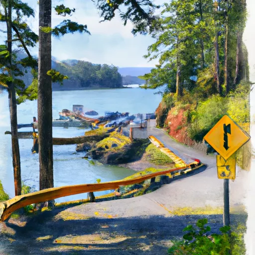
The Cold Water Cove boat ramp is a paved ramp with a moderate slope. It is suitable for small and medium-sized boats. The ramp is 20 feet wide and has a single launch lane. The ramp is also equipped with a courtesy dock that allows boaters to board or disembark from their boats safely.
The boat ramp at Cold Water Cove Campground services Suttle Lake, which is a freshwater lake that covers an area of 253 acres. Suttle Lake is a popular destination for boating, fishing, and swimming. The lake has a maximum depth of 72 feet and is stocked with rainbow trout, kokanee, and Atlantic salmon.
The following types of watercraft are permitted on Suttle Lake: motorized boats, canoes, kayaks, paddleboards, and sailboats. However, there are restrictions on the size and horsepower of motorized boats that are allowed on the lake. Boats with a maximum length of 21 feet and a maximum horsepower of 10 are permitted on the lake.
In conclusion, the Cold Water Cove boat ramp in Oregon is a paved ramp that is suitable for small and medium-sized boats. It services Suttle Lake, which is a popular destination for boating, fishing, and swimming. The ramp is 20 feet wide and has a single launch lane. The lake permits various types of watercraft, including motorized boats with certain restrictions on size and horsepower.
Plan your launch down to the hour
Same weather feed Snoflo's iOS app uses -- updated continuously from NOAA / yr.no.
Next 5 days, hour by hour
Temperature line with weather symbols on top, snow + rain accumulation as columns, humidity as a dotted line.
5-day forecast table
Every 3 hours, broken out across temperature, snow, rain, humidity, and wind.
| Time | Condition | Temp (°F) | Snow (in) | Rain (in) | Humidity (%) | Wind (mps) | Wind dir |
|---|---|---|---|---|---|---|---|
| Loading detailed forecast… | |||||||
15-day temperature & precipitation
Daily temperatures, snow, and rain projected over the next two weeks.
Area streamflow levels
USGS streamgauges around Cold Water Cove Campground -- the same readings that determine whether your launch is safe and your boat is the right craft.
| Streamgauge | Discharge | View |
|---|---|---|
| Mckenzie River At Outlet Of Clear Lake | 165 cfs | → |
| Smith R Ab Smith R Res Nr Belknap Sprgs | 5 cfs | → |
| Mckenzie River Bl Payne Cr | 171 cfs | → |
| Smith River Abv Trail Brdg Resv Nr Belknap Springs | 6 cfs | → |
| Mckenzie R Blw Trail Br Dam Nr Belknap Springs | 607 cfs | → |
| Lookout Creek Near Blue River | 16 cfs | → |
Plan a longer trip
The closest paddle runs, fishing spots, and other boat launches so you can extend a day on the water.
River runs
- Mt. Jefferson Wilderness Boundary To Highway 22
- Headwaters To Mt Jefferson Wilderness Boundary
- Headwaters To Blue River Reservoir
- Headwaters Of Sevenmile Creek To Confluence With Latiwi Creek
- West Section Line Of Sec 31, T12s, R6e To Middle Santiam Wilderness Boundary
- Middle Santiam River
Boating safety & etiquette
- Check the conditions before you launch
- Use the streamflow numbers, weather, and wind forecast on this page. High-cfs whitewater requires whitewater-specific craft and skill.
- Wear your life jacket
- Statistically the single biggest survival factor in a boating incident. State law often requires one per passenger.
- File a float plan
- Tell someone on shore your put-in, take-out, and expected return time. Especially for multi-day or remote trips.
- Yield at the ramp
- Prep gear in the parking lot, not on the ramp. Launch and clear quickly so others can use the lane.
- Clean, drain, dry
- Inspect, clean, drain and dry your boat between waters to prevent the spread of aquatic invasive species.
Set push alerts in the Snoflo app
Save Cold Water Cove Campground as a favorite, set a discharge threshold or a wind/precipitation alert, and the iOS app will push the moment conditions cross.
About Cold Water Cove Campground
Can I launch a motorboat here?
Most Snoflo-tracked launches support motorboats; check the operator for any horsepower restrictions, paddle-only zones, or seasonal closures.
How fresh is the streamflow data?
USGS streamgauges report continuously (every 15 minutes); the table on this page pulls the latest reading at page load.
Is there a fee?
Many federal and state boat launches charge a day-use fee. Check the operator's site before driving out.
What boat is right for these conditions?
Use the nearby streamflow numbers and river-run panel on this page to gauge current conditions. Wider, slower water is friendly for casual paddling and powerboats; high-cfs whitewater requires whitewater-specific craft and skill.
Can I get alerts when conditions change?
Yes -- alerts are managed in the Snoflo iOS app. Favorite this launch, set a threshold (discharge, wind), and you'll get a push the moment it crosses.
Other launches near here
Snoflo-tracked boat launches within driving distance of Cold Water Cove Campground.