Timms Lake -- Access At Se End Of Lake Timms Lake Rd Boat Launch
Community Reviews
Been here? Share the conditions.
Reviews, ratings & photos are added in the free Snoflo iOS app — rate a spot, tag the conditions, and your visit is verified by location. Add or manage your reviews from the app.
Timms Lake -- Access At Se End Of Lake Timms Lake Rd
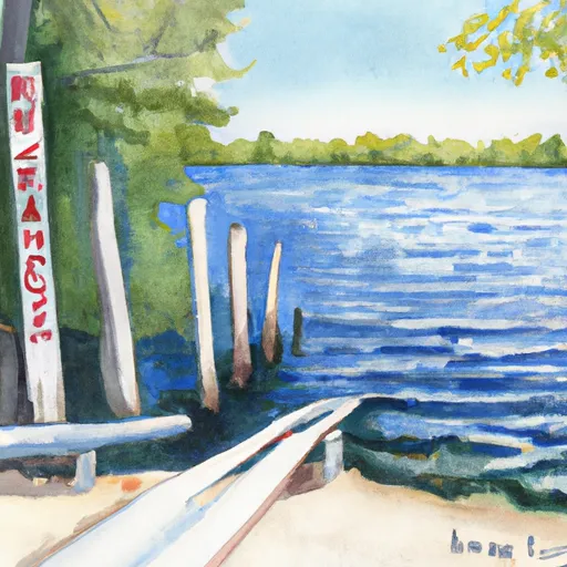
The boat ramp is relatively narrow, with a width of approximately 10-12 feet. It is suitable for launching small to medium-sized boats, including kayaks, canoes, fishing boats, and pontoons.
Timms Lake boat ramp provides access to Timms Lake, which is a small inland lake located in Delta County, Michigan. The lake covers an area of approximately 56 acres, with a maximum depth of 24 feet.
As per Michigan state regulations, all motorized watercraft are permitted on Timms Lake. However, there are speed limits in place to ensure the safety of all water users. Additionally, all boats must comply with the state's boating laws and regulations, including the requirement for life jackets and other safety equipment.
Overall, Timms Lake boat ramp is a convenient and accessible launch point for a variety of watercraft on a small but beautiful Michigan lake.
Plan your launch down to the hour
Same weather feed Snoflo's iOS app uses -- updated continuously from NOAA / yr.no.
Next 5 days, hour by hour
Temperature line with weather symbols on top, snow + rain accumulation as columns, humidity as a dotted line.
5-day forecast table
Every 3 hours, broken out across temperature, snow, rain, humidity, and wind.
| Time | Condition | Temp (°F) | Snow (in) | Rain (in) | Humidity (%) | Wind (mps) | Wind dir |
|---|---|---|---|---|---|---|---|
| Loading detailed forecast… | |||||||
15-day temperature & precipitation
Daily temperatures, snow, and rain projected over the next two weeks.
Area streamflow levels
USGS streamgauges around Timms Lake -- Access At Se End Of Lake Timms Lake Rd -- the same readings that determine whether your launch is safe and your boat is the right craft.
| Streamgauge | Discharge | View |
|---|---|---|
| Menominee River Near Vulcan | 1,450 cfs | → |
| Menominee River Below Pemene Creek Near Pembine | 1,430 cfs | → |
| Menominee River At Niagara | 1,170 cfs | → |
| Pike River At Amberg | 100 cfs | → |
| Menominee River At White Rapids Dam Near Banat | 1,530 cfs | → |
| Menominee River At Twin Falls Near Iron Mt | 3,420 cfs | → |
Plan a longer trip
The closest paddle runs, fishing spots, and other boat launches so you can extend a day on the water.
River runs
- Confluence With Armstrong Creek To Sec 12/13 Line, T35n, R16e
- Sec 12/13 Line, T35n, R16e To Forest Boundary In Sec 24, T35n, R16e
- Forest Road 2398 To Eastern Forest Boundary
- 1/4 Mile Upstream From Evans Bridge To Confluence With Armstrong Creek
- South Branch--Origin In Sec 25, T38n, R14e To Confluence With Main Branch
- 1/4 Mile Downstream From Ccc Bridge To 1/4 Mile Upstream From Evans Bridge
Nearby fishing
Boating safety & etiquette
- Check the conditions before you launch
- Use the streamflow numbers, weather, and wind forecast on this page. High-cfs whitewater requires whitewater-specific craft and skill.
- Wear your life jacket
- Statistically the single biggest survival factor in a boating incident. State law often requires one per passenger.
- File a float plan
- Tell someone on shore your put-in, take-out, and expected return time. Especially for multi-day or remote trips.
- Yield at the ramp
- Prep gear in the parking lot, not on the ramp. Launch and clear quickly so others can use the lane.
- Clean, drain, dry
- Inspect, clean, drain and dry your boat between waters to prevent the spread of aquatic invasive species.
Set push alerts in the Snoflo app
Save Timms Lake -- Access At Se End Of Lake Timms Lake Rd as a favorite, set a discharge threshold or a wind/precipitation alert, and the iOS app will push the moment conditions cross.
About Timms Lake -- Access At Se End Of Lake Timms Lake Rd
Can I launch a motorboat here?
Most Snoflo-tracked launches support motorboats; check the operator for any horsepower restrictions, paddle-only zones, or seasonal closures.
How fresh is the streamflow data?
USGS streamgauges report continuously (every 15 minutes); the table on this page pulls the latest reading at page load.
Is there a fee?
Many federal and state boat launches charge a day-use fee. Check the operator's site before driving out.
What boat is right for these conditions?
Use the nearby streamflow numbers and river-run panel on this page to gauge current conditions. Wider, slower water is friendly for casual paddling and powerboats; high-cfs whitewater requires whitewater-specific craft and skill.
Can I get alerts when conditions change?
Yes -- alerts are managed in the Snoflo iOS app. Favorite this launch, set a threshold (discharge, wind), and you'll get a push the moment it crosses.
Other launches near here
Snoflo-tracked boat launches within driving distance of Timms Lake -- Access At Se End Of Lake Timms Lake Rd .