Grafton Pond Boat Launch Boat Launch
Community Reviews
Been here? Share the conditions.
Reviews, ratings & photos are added in the free Snoflo iOS app — rate a spot, tag the conditions, and your visit is verified by location. Add or manage your reviews from the app.
Grafton Pond Boat Launch
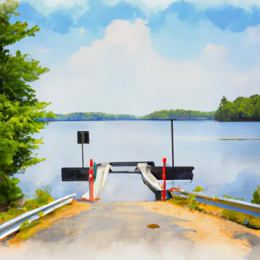
According to the official website of the New Hampshire Fish and Game Department, the Grafton Pond boat launch is a concrete ramp that is 12 feet wide. It is suitable for launching small boats, canoes, and kayaks. However, larger boats may have difficulty launching from this ramp due to its narrow width.
Grafton Pond is a popular destination for fishing, boating, and wildlife viewing. The pond is stocked with trout by the New Hampshire Fish and Game Department, and it is home to a variety of fish species, including pickerel, bass, and perch. The water is also home to a variety of bird species, such as loons, ospreys, and bald eagles.
In terms of regulations, boaters are required to follow all New Hampshire boating laws and regulations when using Grafton Pond. This includes having proper safety equipment on board, such as life jackets and a throwable flotation device. Additionally, boaters are required to obtain a New Hampshire boating license if they are operating a motorized boat on the water.
Overall, the Grafton Pond boat launch is a small but convenient public boat ramp that provides access to a beautiful and popular recreational area in New Hampshire. Anyone planning to use this boat ramp should be aware of its narrow width and the regulations governing the use of the pond.
Plan your launch down to the hour
Same weather feed Snoflo's iOS app uses -- updated continuously from NOAA / yr.no.
Next 5 days, hour by hour
Temperature line with weather symbols on top, snow + rain accumulation as columns, humidity as a dotted line.
5-day forecast table
Every 3 hours, broken out across temperature, snow, rain, humidity, and wind.
| Time | Condition | Temp (°F) | Snow (in) | Rain (in) | Humidity (%) | Wind (mps) | Wind dir |
|---|---|---|---|---|---|---|---|
| Loading detailed forecast… | |||||||
15-day temperature & precipitation
Daily temperatures, snow, and rain projected over the next two weeks.
Area streamflow levels
USGS streamgauges around Grafton Pond Boat Launch -- the same readings that determine whether your launch is safe and your boat is the right craft.
| Streamgauge | Discharge | View |
|---|---|---|
| Connecticut River At West Lebanon | 1,910 cfs | → |
| Smith River Near Bristol | 14 cfs | → |
| Ottauquechee River At North Hartland | 81 cfs | → |
| Ompompanoosuc River At Union Village | 16 cfs | → |
| Baker River Near Rumney | 26 cfs | → |
| Sugar River At West Claremont | 73 cfs | → |
Plan a longer trip
The closest paddle runs, fishing spots, and other boat launches so you can extend a day on the water.
Boating safety & etiquette
- Check the conditions before you launch
- Use the streamflow numbers, weather, and wind forecast on this page. High-cfs whitewater requires whitewater-specific craft and skill.
- Wear your life jacket
- Statistically the single biggest survival factor in a boating incident. State law often requires one per passenger.
- File a float plan
- Tell someone on shore your put-in, take-out, and expected return time. Especially for multi-day or remote trips.
- Yield at the ramp
- Prep gear in the parking lot, not on the ramp. Launch and clear quickly so others can use the lane.
- Clean, drain, dry
- Inspect, clean, drain and dry your boat between waters to prevent the spread of aquatic invasive species.
Set push alerts in the Snoflo app
Save Grafton Pond Boat Launch as a favorite, set a discharge threshold or a wind/precipitation alert, and the iOS app will push the moment conditions cross.
About Grafton Pond Boat Launch
Can I launch a motorboat here?
Most Snoflo-tracked launches support motorboats; check the operator for any horsepower restrictions, paddle-only zones, or seasonal closures.
How fresh is the streamflow data?
USGS streamgauges report continuously (every 15 minutes); the table on this page pulls the latest reading at page load.
Is there a fee?
Many federal and state boat launches charge a day-use fee. Check the operator's site before driving out.
What boat is right for these conditions?
Use the nearby streamflow numbers and river-run panel on this page to gauge current conditions. Wider, slower water is friendly for casual paddling and powerboats; high-cfs whitewater requires whitewater-specific craft and skill.
Can I get alerts when conditions change?
Yes -- alerts are managed in the Snoflo iOS app. Favorite this launch, set a threshold (discharge, wind), and you'll get a push the moment it crosses.
Other launches near here
Snoflo-tracked boat launches within driving distance of Grafton Pond Boat Launch.