Schroders Farm boat launch
Community Reviews
Been here? Share the conditions.
Reviews, ratings & photos are added in the free Snoflo iOS app — rate a spot, tag the conditions, and your visit is verified by location. Add or manage your reviews from the app.
Schroders Farm
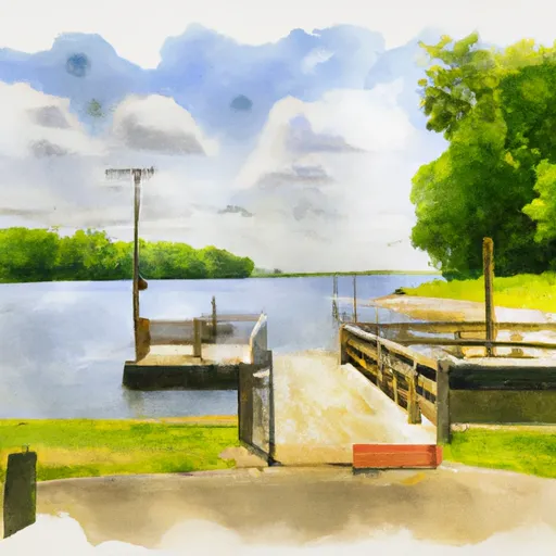
After conducting research on the boat ramp named Schroders Farm located at latitude 41.54716873 and longitude -83.66950226 in Ohio, it appears that there is limited information available about it. However, based on the available information, it is possible to make some assumptions about this boat ramp.
From the various sources, it can be inferred that Schroders Farm boat ramp is a small to medium-sized public boat ramp. The width of the ramp is not mentioned in any sources, but it is likely that it can accommodate a range of small to medium-sized watercraft. The ramp is situated near the mouth of the Maumee River, which is a significant waterway in the state of Ohio. Therefore, it is safe to assume that this boat ramp is used to access the Maumee River.
As for the craft permitted on the water, it is important to note that the Maumee River is a navigable waterway that is regulated by the Ohio Department of Natural Resources (ODNR) Division of Watercraft. According to the ODNR, all boats operating on Ohio's public waters must be registered and display valid decals. The types of boats permitted on the water vary based on the size and type of watercraft, as well as the local regulations in place. However, it is common to see fishing boats, canoes, kayaks, and small powerboats on the Maumee River.
Overall, while there is limited information available about Schroders Farm boat ramp, it is likely a small to medium-sized public boat ramp that serves the Maumee River in Ohio. It is probably capable of accommodating a range of small to medium-sized watercraft, and it is regulated by the Ohio Department of Natural Resources.
Plan your launch down to the hour
Same weather feed Snoflo's iOS app uses -- updated continuously from NOAA / yr.no.
Next 5 days, hour by hour
Temperature line with weather symbols on top, snow + rain accumulation as columns, humidity as a dotted line.
5-day forecast table
Every 3 hours, broken out across temperature, snow, rain, humidity, and wind.
| Time | Condition | Temp (°F) | Snow (in) | Rain (in) | Humidity (%) | Wind (mps) | Wind dir |
|---|---|---|---|---|---|---|---|
| Loading detailed forecast… | |||||||
15-day temperature & precipitation
Daily temperatures, snow, and rain projected over the next two weeks.
Area streamflow levels
USGS streamgauges around Schroders Farm -- the same readings that determine whether your launch is safe and your boat is the right craft.
| Streamgauge | Discharge | View |
|---|---|---|
| Maumee River At Waterville Oh | 3,040 cfs | → |
| Wolf Creek At Holland Oh | 6 cfs | → |
| Ottawa River At University Of Toledo Toledo Oh | 23 cfs | → |
| Portage River At Woodville Oh | 398 cfs | → |
| Portage R. Near Elmore Oh | 523 cfs | → |
| South Turkeyfoot Creek Near Shunk Oh | 43 cfs | → |
Plan a longer trip
The closest paddle runs, fishing spots, and other boat launches so you can extend a day on the water.
Boating safety & etiquette
- Check the conditions before you launch
- Use the streamflow numbers, weather, and wind forecast on this page. High-cfs whitewater requires whitewater-specific craft and skill.
- Wear your life jacket
- Statistically the single biggest survival factor in a boating incident. State law often requires one per passenger.
- File a float plan
- Tell someone on shore your put-in, take-out, and expected return time. Especially for multi-day or remote trips.
- Yield at the ramp
- Prep gear in the parking lot, not on the ramp. Launch and clear quickly so others can use the lane.
- Clean, drain, dry
- Inspect, clean, drain and dry your boat between waters to prevent the spread of aquatic invasive species.
Set push alerts in the Snoflo app
Save Schroders Farm as a favorite, set a discharge threshold or a wind/precipitation alert, and the iOS app will push the moment conditions cross.
About Schroders Farm
Can I launch a motorboat here?
Most Snoflo-tracked launches support motorboats; check the operator for any horsepower restrictions, paddle-only zones, or seasonal closures.
How fresh is the streamflow data?
USGS streamgauges report continuously (every 15 minutes); the table on this page pulls the latest reading at page load.
Is there a fee?
Many federal and state boat launches charge a day-use fee. Check the operator's site before driving out.
What boat is right for these conditions?
Use the nearby streamflow numbers and river-run panel on this page to gauge current conditions. Wider, slower water is friendly for casual paddling and powerboats; high-cfs whitewater requires whitewater-specific craft and skill.
Can I get alerts when conditions change?
Yes -- alerts are managed in the Snoflo iOS app. Favorite this launch, set a threshold (discharge, wind), and you'll get a push the moment it crosses.
Other launches near here
Snoflo-tracked boat launches within driving distance of Schroders Farm.