Chiloquin Access Boat Launch
Community Reviews
Been here? Share the conditions.
Reviews, ratings & photos are added in the free Snoflo iOS app — rate a spot, tag the conditions, and your visit is verified by location. Add or manage your reviews from the app.
Chiloquin Access
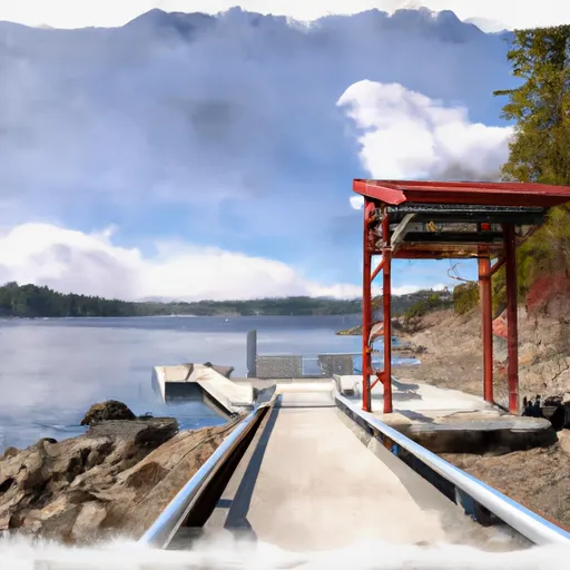
According to the latest available information, Chiloquin Access is a concrete boat ramp that is approximately 16 feet wide. It is designed for launching and retrieving small boats, canoes, and kayaks. Larger boats may also be able to use the ramp, but only if they are launched and retrieved with the assistance of a trailer.
In terms of regulations, all watercraft must comply with the state of Oregon's boating laws and regulations. This includes carrying the appropriate safety equipment, adhering to speed limits, and following other navigational rules. Additionally, the use of personal watercraft (such as jet skis) is prohibited on Agency Lake.
Overall, Chiloquin Access is a well-maintained boat ramp that provides convenient access to a beautiful and popular body of water in southern Oregon. It is an excellent choice for anglers, boaters, and other water enthusiasts who want to explore the natural beauty of this area.
Plan your launch down to the hour
Same weather feed Snoflo's iOS app uses -- updated continuously from NOAA / yr.no.
Next 5 days, hour by hour
Temperature line with weather symbols on top, snow + rain accumulation as columns, humidity as a dotted line.
5-day forecast table
Every 3 hours, broken out across temperature, snow, rain, humidity, and wind.
| Time | Condition | Temp (°F) | Snow (in) | Rain (in) | Humidity (%) | Wind (mps) | Wind dir |
|---|---|---|---|---|---|---|---|
| Loading detailed forecast… | |||||||
15-day temperature & precipitation
Daily temperatures, snow, and rain projected over the next two weeks.
Area streamflow levels
USGS streamgauges around Chiloquin Access -- the same readings that determine whether your launch is safe and your boat is the right craft.
| Streamgauge | Discharge | View |
|---|---|---|
| Williamson River Blw Sprague River Nr Chiloquin | 490 cfs | → |
| Sprague River Near Chiloquin | 155 cfs | → |
| Wood River Near Klamath Agency | 352 cfs | → |
| Sevenmile Cnl At Dike Rd Br | 34 cfs | → |
| Williamson River Near Klamath Agency | · | → |
| Link River At Klamath Falls | 1,170 cfs | → |
Plan a longer trip
The closest paddle runs, fishing spots, and other boat launches so you can extend a day on the water.
River runs
- Headwaters To Sw1/4 Of Sec 1, T33s, R4e
- South Fork Little Butte Creek
- Headwaters To Confluence With Rogue River
- Sw1/4 Of Sec 1, T33s, R4e To Rogue River Nf Boundary
- Big Butte Creek (Incl South Fork Big Butte Creek)
- Crater Lake Np Boundary To Confluence With Rogue River
Boating safety & etiquette
- Check the conditions before you launch
- Use the streamflow numbers, weather, and wind forecast on this page. High-cfs whitewater requires whitewater-specific craft and skill.
- Wear your life jacket
- Statistically the single biggest survival factor in a boating incident. State law often requires one per passenger.
- File a float plan
- Tell someone on shore your put-in, take-out, and expected return time. Especially for multi-day or remote trips.
- Yield at the ramp
- Prep gear in the parking lot, not on the ramp. Launch and clear quickly so others can use the lane.
- Clean, drain, dry
- Inspect, clean, drain and dry your boat between waters to prevent the spread of aquatic invasive species.
Set push alerts in the Snoflo app
Save Chiloquin Access as a favorite, set a discharge threshold or a wind/precipitation alert, and the iOS app will push the moment conditions cross.
About Chiloquin Access
Can I launch a motorboat here?
Most Snoflo-tracked launches support motorboats; check the operator for any horsepower restrictions, paddle-only zones, or seasonal closures.
How fresh is the streamflow data?
USGS streamgauges report continuously (every 15 minutes); the table on this page pulls the latest reading at page load.
Is there a fee?
Many federal and state boat launches charge a day-use fee. Check the operator's site before driving out.
What boat is right for these conditions?
Use the nearby streamflow numbers and river-run panel on this page to gauge current conditions. Wider, slower water is friendly for casual paddling and powerboats; high-cfs whitewater requires whitewater-specific craft and skill.
Can I get alerts when conditions change?
Yes -- alerts are managed in the Snoflo iOS app. Favorite this launch, set a threshold (discharge, wind), and you'll get a push the moment it crosses.
Other launches near here
Snoflo-tracked boat launches within driving distance of Chiloquin Access.