Hoover Campground Boat Launch
Community Reviews
Been here? Share the conditions.
Reviews, ratings & photos are added in the free Snoflo iOS app — rate a spot, tag the conditions, and your visit is verified by location. Add or manage your reviews from the app.
Hoover Campground
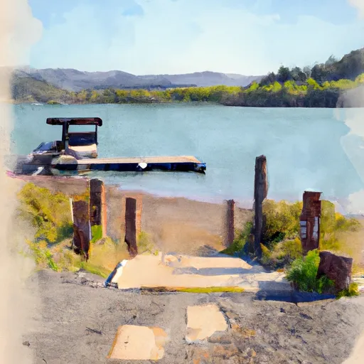
The Hoover Campground boat ramp services the Detroit Lake, a popular destination for fishing, swimming, and boating. Detroit Lake is a large reservoir that stretches for about 9.5 miles, covering an area of approximately 3,500 acres. The lake is known for its crystal-clear waters, scenic beauty, and abundant fish populations, making it a popular spot for anglers.
The lake is open to a variety of watercraft, including motorboats, sailboats, kayaks, canoes, and paddleboards. However, the use of personal watercraft (such as jet skis) is prohibited on Detroit Lake. Boaters are advised to follow all safety regulations, including wearing properly fitted life jackets and carrying all necessary equipment.
In summary, the Hoover Campground boat ramp is a concrete ramp that services the Detroit Lake in Oregon. It is 12 feet wide and can accommodate small to medium-sized watercraft. The lake is open to a variety of vessels, with the exception of personal watercraft. Boaters are advised to follow all safety protocols and regulations when using the ramp and the lake.
Plan your launch down to the hour
Same weather feed Snoflo's iOS app uses -- updated continuously from NOAA / yr.no.
Next 5 days, hour by hour
Temperature line with weather symbols on top, snow + rain accumulation as columns, humidity as a dotted line.
5-day forecast table
Every 3 hours, broken out across temperature, snow, rain, humidity, and wind.
| Time | Condition | Temp (°F) | Snow (in) | Rain (in) | Humidity (%) | Wind (mps) | Wind dir |
|---|---|---|---|---|---|---|---|
| Loading detailed forecast… | |||||||
15-day temperature & precipitation
Daily temperatures, snow, and rain projected over the next two weeks.
Area streamflow levels
USGS streamgauges around Hoover Campground -- the same readings that determine whether your launch is safe and your boat is the right craft.
| Streamgauge | Discharge | View |
|---|---|---|
| No Santiam R Blw Boulder Crk | 410 cfs | → |
| Breitenbush R Abv French Cr Nr Detroit | 124 cfs | → |
| Blowout Creek Near Detroit | 7 cfs | → |
| North Santiam River At Niagara | 1,030 cfs | → |
| Schafer Creek Near Lacomb | 0 cfs | → |
| Quartzville Creek Near Cascadia | 27 cfs | → |
Plan a longer trip
The closest paddle runs, fishing spots, and other boat launches so you can extend a day on the water.
River runs
- Confluence With North Fork Breitenbush River To Detroit Reservoir
- Highway 22 To Confluence With Rainbow Creek
- North Santiam River
- Mt. Jefferson Wilderness Boundary To Confluence With Breitenbush River
- Headwaters To Confluence With Unnamed Creek West Of Bruler Creek
- Opal Lake To Confluence With Battle Axe Creek
Boating safety & etiquette
- Check the conditions before you launch
- Use the streamflow numbers, weather, and wind forecast on this page. High-cfs whitewater requires whitewater-specific craft and skill.
- Wear your life jacket
- Statistically the single biggest survival factor in a boating incident. State law often requires one per passenger.
- File a float plan
- Tell someone on shore your put-in, take-out, and expected return time. Especially for multi-day or remote trips.
- Yield at the ramp
- Prep gear in the parking lot, not on the ramp. Launch and clear quickly so others can use the lane.
- Clean, drain, dry
- Inspect, clean, drain and dry your boat between waters to prevent the spread of aquatic invasive species.
Set push alerts in the Snoflo app
Save Hoover Campground as a favorite, set a discharge threshold or a wind/precipitation alert, and the iOS app will push the moment conditions cross.
About Hoover Campground
Can I launch a motorboat here?
Most Snoflo-tracked launches support motorboats; check the operator for any horsepower restrictions, paddle-only zones, or seasonal closures.
How fresh is the streamflow data?
USGS streamgauges report continuously (every 15 minutes); the table on this page pulls the latest reading at page load.
Is there a fee?
Many federal and state boat launches charge a day-use fee. Check the operator's site before driving out.
What boat is right for these conditions?
Use the nearby streamflow numbers and river-run panel on this page to gauge current conditions. Wider, slower water is friendly for casual paddling and powerboats; high-cfs whitewater requires whitewater-specific craft and skill.
Can I get alerts when conditions change?
Yes -- alerts are managed in the Snoflo iOS app. Favorite this launch, set a threshold (discharge, wind), and you'll get a push the moment it crosses.
Other launches near here
Snoflo-tracked boat launches within driving distance of Hoover Campground.