Knights Bridge Boat Launch
Community Reviews
Been here? Share the conditions.
Reviews, ratings & photos are added in the free Snoflo iOS app — rate a spot, tag the conditions, and your visit is verified by location. Add or manage your reviews from the app.
Knights Bridge
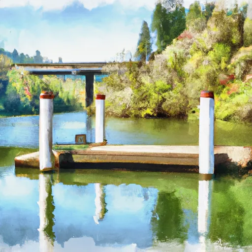
Upon conducting research, it appears that the boat ramp named Knights Bridge is located on the Clackamas River, specifically in the city of Oregon City, Oregon. The ramp is described as a concrete, single-lane boat ramp, which is suitable for smaller watercraft. According to the latest information available, the ramp is approximately 14 feet wide, which offers sufficient space for launching and retrieving boats.
The Clackamas River is a popular destination for fishing and recreational boating, and Knights Bridge boat ramp is a convenient access point for those who wish to explore the river. The river is approximately 83 miles long and is a tributary of the Willamette River, which flows through western Oregon.
As for the types of boats that are permitted on the river, it appears that there are no restrictions on the type of vessel that can be launched from Knights Bridge boat ramp. However, due to the narrowness of the ramp and the relatively shallow waters of the Clackamas River in some areas, it is recommended that only smaller boats, such as canoes, kayaks, and small motorized boats, be launched from this location.
In conclusion, Knights Bridge boat ramp is a concrete, single-lane ramp located on the Clackamas River in Oregon City, Oregon. It is approximately 14 feet wide and is suitable for launching smaller watercraft. The Clackamas River is a popular destination for fishing and recreational boating, and there are no restrictions on the types of boats that can be launched from this ramp, although smaller vessels are recommended.
Plan your launch down to the hour
Same weather feed Snoflo's iOS app uses -- updated continuously from NOAA / yr.no.
Next 5 days, hour by hour
Temperature line with weather symbols on top, snow + rain accumulation as columns, humidity as a dotted line.
5-day forecast table
Every 3 hours, broken out across temperature, snow, rain, humidity, and wind.
| Time | Condition | Temp (°F) | Snow (in) | Rain (in) | Humidity (%) | Wind (mps) | Wind dir |
|---|---|---|---|---|---|---|---|
| Loading detailed forecast… | |||||||
15-day temperature & precipitation
Daily temperatures, snow, and rain projected over the next two weeks.
Area streamflow levels
USGS streamgauges around Knights Bridge -- the same readings that determine whether your launch is safe and your boat is the right craft.
| Streamgauge | Discharge | View |
|---|---|---|
| Molalla River Near Canby | 84 cfs | → |
| Pudding River At Aurora | 32 cfs | → |
| Tualatin River At West Linn | 227 cfs | → |
| Pudding River Near Woodburn | 7 cfs | → |
| Fanno Creek At Durham | 2 cfs | → |
| Clackamas River Near Oregon City | 711 cfs | → |
Plan a longer trip
The closest paddle runs, fishing spots, and other boat launches so you can extend a day on the water.
Boating safety & etiquette
- Check the conditions before you launch
- Use the streamflow numbers, weather, and wind forecast on this page. High-cfs whitewater requires whitewater-specific craft and skill.
- Wear your life jacket
- Statistically the single biggest survival factor in a boating incident. State law often requires one per passenger.
- File a float plan
- Tell someone on shore your put-in, take-out, and expected return time. Especially for multi-day or remote trips.
- Yield at the ramp
- Prep gear in the parking lot, not on the ramp. Launch and clear quickly so others can use the lane.
- Clean, drain, dry
- Inspect, clean, drain and dry your boat between waters to prevent the spread of aquatic invasive species.
Set push alerts in the Snoflo app
Save Knights Bridge as a favorite, set a discharge threshold or a wind/precipitation alert, and the iOS app will push the moment conditions cross.
About Knights Bridge
Can I launch a motorboat here?
Most Snoflo-tracked launches support motorboats; check the operator for any horsepower restrictions, paddle-only zones, or seasonal closures.
How fresh is the streamflow data?
USGS streamgauges report continuously (every 15 minutes); the table on this page pulls the latest reading at page load.
Is there a fee?
Many federal and state boat launches charge a day-use fee. Check the operator's site before driving out.
What boat is right for these conditions?
Use the nearby streamflow numbers and river-run panel on this page to gauge current conditions. Wider, slower water is friendly for casual paddling and powerboats; high-cfs whitewater requires whitewater-specific craft and skill.
Can I get alerts when conditions change?
Yes -- alerts are managed in the Snoflo iOS app. Favorite this launch, set a threshold (discharge, wind), and you'll get a push the moment it crosses.
Other launches near here
Snoflo-tracked boat launches within driving distance of Knights Bridge .