North Side Lebanon Dam Boat Launch
Community Reviews
Been here? Share the conditions.
Reviews, ratings & photos are added in the free Snoflo iOS app — rate a spot, tag the conditions, and your visit is verified by location. Add or manage your reviews from the app.
North Side Lebanon Dam
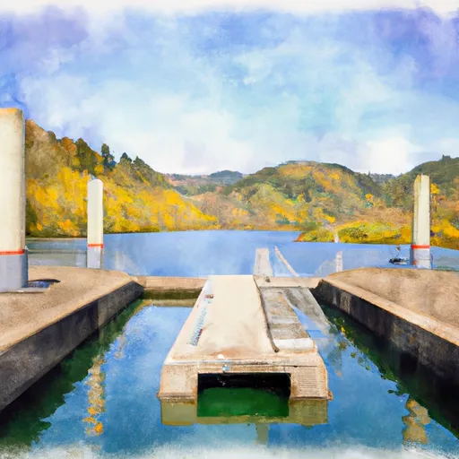
The North Side Lebanon Dam boat ramp is a concrete ramp that is approximately 20 feet wide, making it suitable for launching and retrieving small to medium-sized watercraft. The ramp provides easy access to the river, making it a popular spot for anglers, kayakers, canoeists, and other boaters.
The South Santiam River is a popular fishing destination, with populations of rainbow trout, cutthroat trout, and steelhead. The river is also ideal for kayaking and canoeing, with stretches of flat water and rapids that range from class I to class III.
As for the types of boats permitted on the South Santiam River, the Oregon Department of Fish and Wildlife specifies that motorized boats are permitted, but they must adhere to specific speed limits. In addition, watercraft must be registered with the state and display valid registration tags.
Overall, the North Side Lebanon Dam boat ramp provides convenient access to the South Santiam River, making it a popular destination for anglers, kayakers, and other boaters looking to explore the waterways of Oregon.
Plan your launch down to the hour
Same weather feed Snoflo's iOS app uses -- updated continuously from NOAA / yr.no.
Next 5 days, hour by hour
Temperature line with weather symbols on top, snow + rain accumulation as columns, humidity as a dotted line.
5-day forecast table
Every 3 hours, broken out across temperature, snow, rain, humidity, and wind.
| Time | Condition | Temp (°F) | Snow (in) | Rain (in) | Humidity (%) | Wind (mps) | Wind dir |
|---|---|---|---|---|---|---|---|
| Loading detailed forecast… | |||||||
15-day temperature & precipitation
Daily temperatures, snow, and rain projected over the next two weeks.
Area streamflow levels
USGS streamgauges around North Side Lebanon Dam -- the same readings that determine whether your launch is safe and your boat is the right craft.
| Streamgauge | Discharge | View |
|---|---|---|
| Lebanon Santiam Canal Near Lebanon | 74 cfs | → |
| South Santiam River At Waterloo | 804 cfs | → |
| South Santiam River Near Foster | 879 cfs | → |
| Thomas Creek Near Scio | 17 cfs | → |
| North Santiam River Near Jefferson | 790 cfs | → |
| Willamette River At Albany | 4,170 cfs | → |
Plan a longer trip
The closest paddle runs, fishing spots, and other boat launches so you can extend a day on the water.
Boating safety & etiquette
- Check the conditions before you launch
- Use the streamflow numbers, weather, and wind forecast on this page. High-cfs whitewater requires whitewater-specific craft and skill.
- Wear your life jacket
- Statistically the single biggest survival factor in a boating incident. State law often requires one per passenger.
- File a float plan
- Tell someone on shore your put-in, take-out, and expected return time. Especially for multi-day or remote trips.
- Yield at the ramp
- Prep gear in the parking lot, not on the ramp. Launch and clear quickly so others can use the lane.
- Clean, drain, dry
- Inspect, clean, drain and dry your boat between waters to prevent the spread of aquatic invasive species.
Set push alerts in the Snoflo app
Save North Side Lebanon Dam as a favorite, set a discharge threshold or a wind/precipitation alert, and the iOS app will push the moment conditions cross.
About North Side Lebanon Dam
Can I launch a motorboat here?
Most Snoflo-tracked launches support motorboats; check the operator for any horsepower restrictions, paddle-only zones, or seasonal closures.
How fresh is the streamflow data?
USGS streamgauges report continuously (every 15 minutes); the table on this page pulls the latest reading at page load.
Is there a fee?
Many federal and state boat launches charge a day-use fee. Check the operator's site before driving out.
What boat is right for these conditions?
Use the nearby streamflow numbers and river-run panel on this page to gauge current conditions. Wider, slower water is friendly for casual paddling and powerboats; high-cfs whitewater requires whitewater-specific craft and skill.
Can I get alerts when conditions change?
Yes -- alerts are managed in the Snoflo iOS app. Favorite this launch, set a threshold (discharge, wind), and you'll get a push the moment it crosses.
Other launches near here
Snoflo-tracked boat launches within driving distance of North Side Lebanon Dam.