Sandhole Road, Georgetown Boat Launch
Community Reviews
Been here? Share the conditions.
Reviews, ratings & photos are added in the free Snoflo iOS app — rate a spot, tag the conditions, and your visit is verified by location. Add or manage your reviews from the app.
Sandhole Road, Georgetown
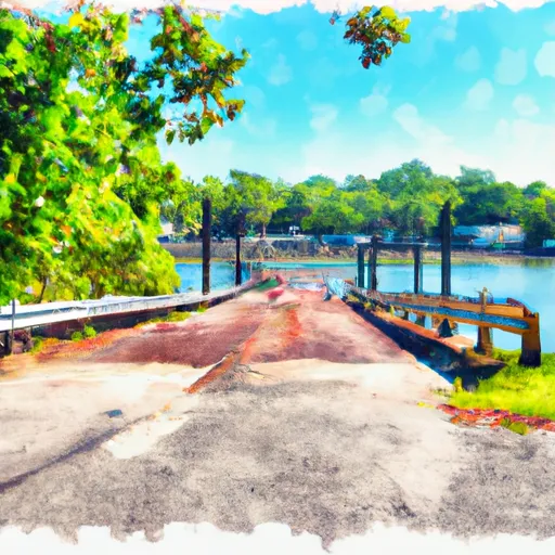
According to the latest information available, the Sandhole Road boat ramp in Georgetown, South Carolina, is a concrete boat ramp that is approximately 24 feet wide. It provides access to the Black River, which is a slow-moving, brackish waterway that flows into Winyah Bay and then out to the Atlantic Ocean.
The Sandhole Road boat ramp is suitable for launching small to medium-sized boats, including fishing boats, jon boats, and pontoon boats. Jet skis and other personal watercraft are also permitted on the waterway. However, larger vessels and sailboats may have difficulty navigating the shallow waters of the Black River.
Overall, the Sandhole Road boat ramp is a popular destination for anglers and boaters in the Georgetown area, offering easy access to a scenic and productive fishing spot. It is well-maintained and easily accessible, with ample parking and basic amenities such as restrooms and picnic tables.
Plan your launch down to the hour
Same weather feed Snoflo's iOS app uses -- updated continuously from NOAA / yr.no.
Next 5 days, hour by hour
Temperature line with weather symbols on top, snow + rain accumulation as columns, humidity as a dotted line.
5-day forecast table
Every 3 hours, broken out across temperature, snow, rain, humidity, and wind.
| Time | Condition | Temp (°F) | Snow (in) | Rain (in) | Humidity (%) | Wind (mps) | Wind dir |
|---|---|---|---|---|---|---|---|
| Loading detailed forecast… | |||||||
15-day temperature & precipitation
Daily temperatures, snow, and rain projected over the next two weeks.
Area streamflow levels
USGS streamgauges around Sandhole Road, Georgetown -- the same readings that determine whether your launch is safe and your boat is the right craft.
| Streamgauge | Discharge | View |
|---|---|---|
| Santee River Nr Jamestown | 1,660 cfs | → |
| Turkey Creek Near Maryville | 0 cfs | → |
| Lake Moultrie Tailrace Canal At Moncks Corner | 1,030 cfs | → |
| Back River At Dupont Intake Nr Kittredge | 3,790 cfs | → |
| Black River At Kingstree | 22 cfs | → |
Plan a longer trip
The closest paddle runs, fishing spots, and other boat launches so you can extend a day on the water.
Boating safety & etiquette
- Check the conditions before you launch
- Use the streamflow numbers, weather, and wind forecast on this page. High-cfs whitewater requires whitewater-specific craft and skill.
- Wear your life jacket
- Statistically the single biggest survival factor in a boating incident. State law often requires one per passenger.
- File a float plan
- Tell someone on shore your put-in, take-out, and expected return time. Especially for multi-day or remote trips.
- Yield at the ramp
- Prep gear in the parking lot, not on the ramp. Launch and clear quickly so others can use the lane.
- Clean, drain, dry
- Inspect, clean, drain and dry your boat between waters to prevent the spread of aquatic invasive species.
Set push alerts in the Snoflo app
Save Sandhole Road, Georgetown as a favorite, set a discharge threshold or a wind/precipitation alert, and the iOS app will push the moment conditions cross.
About Sandhole Road, Georgetown
Can I launch a motorboat here?
Most Snoflo-tracked launches support motorboats; check the operator for any horsepower restrictions, paddle-only zones, or seasonal closures.
How fresh is the streamflow data?
USGS streamgauges report continuously (every 15 minutes); the table on this page pulls the latest reading at page load.
Is there a fee?
Many federal and state boat launches charge a day-use fee. Check the operator's site before driving out.
What boat is right for these conditions?
Use the nearby streamflow numbers and river-run panel on this page to gauge current conditions. Wider, slower water is friendly for casual paddling and powerboats; high-cfs whitewater requires whitewater-specific craft and skill.
Can I get alerts when conditions change?
Yes -- alerts are managed in the Snoflo iOS app. Favorite this launch, set a threshold (discharge, wind), and you'll get a push the moment it crosses.
Other launches near here
Snoflo-tracked boat launches within driving distance of Sandhole Road, Georgetown.