Ridge Harbor Drive Burnet County Boat Launch
Community Reviews
Been here? Share the conditions.
Reviews, ratings & photos are added in the free Snoflo iOS app — rate a spot, tag the conditions, and your visit is verified by location. Add or manage your reviews from the app.
Ridge Harbor Drive Burnet County
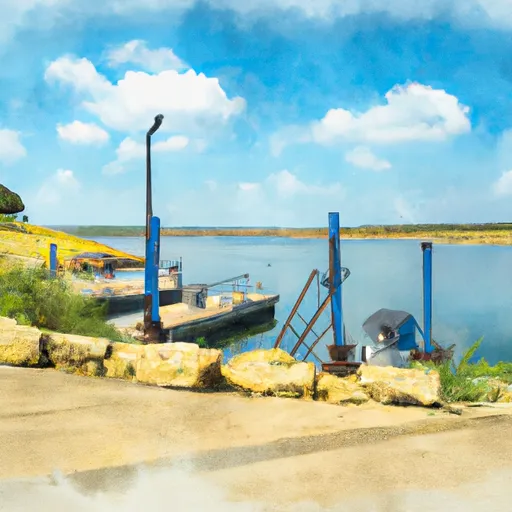
According to recent reports, the Ridge Harbor Drive boat ramp is a wide and well-maintained concrete ramp that can accommodate a variety of watercraft, including motorboats, sailboats, and personal watercraft. The ramp is also equipped with ample parking for vehicles and trailers.
Lake Travis is a large reservoir that covers over 18,000 acres and features numerous coves, inlets, and islands. It is a popular destination for boating, fishing, swimming, and other water-based activities. The lake is also home to several marinas, boat rental companies, and waterfront restaurants.
As with most public boat ramps, there may be certain restrictions or regulations in place regarding the use of the ramp and the types of watercraft that are allowed on the water. It is recommended to check with local authorities or the managing agency for up-to-date information on any restrictions or guidelines that may apply.
Plan your launch down to the hour
Same weather feed Snoflo's iOS app uses -- updated continuously from NOAA / yr.no.
Next 5 days, hour by hour
Temperature line with weather symbols on top, snow + rain accumulation as columns, humidity as a dotted line.
5-day forecast table
Every 3 hours, broken out across temperature, snow, rain, humidity, and wind.
| Time | Condition | Temp (°F) | Snow (in) | Rain (in) | Humidity (%) | Wind (mps) | Wind dir |
|---|---|---|---|---|---|---|---|
| Loading detailed forecast… | |||||||
15-day temperature & precipitation
Daily temperatures, snow, and rain projected over the next two weeks.
Area streamflow levels
USGS streamgauges around Ridge Harbor Drive Burnet County -- the same readings that determine whether your launch is safe and your boat is the right craft.
| Streamgauge | Discharge | View |
|---|---|---|
| Barton Ck At Sh 71 Nr Oak Hill | 7 cfs | → |
| Lake Ck At Lake Ck Pkwy Nr Austin | 1 cfs | → |
| Bull Ck At Loop 360 Nr Austin | 3 cfs | → |
| Brushy Ck At Cedar Park | 57 cfs | → |
| Barton Ck At Lost Ck Blvd Nr Austin | 10 cfs | → |
| Sandy Ck Nr Kingsland | 9 cfs | → |
Plan a longer trip
The closest paddle runs, fishing spots, and other boat launches so you can extend a day on the water.
Boating safety & etiquette
- Check the conditions before you launch
- Use the streamflow numbers, weather, and wind forecast on this page. High-cfs whitewater requires whitewater-specific craft and skill.
- Wear your life jacket
- Statistically the single biggest survival factor in a boating incident. State law often requires one per passenger.
- File a float plan
- Tell someone on shore your put-in, take-out, and expected return time. Especially for multi-day or remote trips.
- Yield at the ramp
- Prep gear in the parking lot, not on the ramp. Launch and clear quickly so others can use the lane.
- Clean, drain, dry
- Inspect, clean, drain and dry your boat between waters to prevent the spread of aquatic invasive species.
Set push alerts in the Snoflo app
Save Ridge Harbor Drive Burnet County as a favorite, set a discharge threshold or a wind/precipitation alert, and the iOS app will push the moment conditions cross.
About Ridge Harbor Drive Burnet County
Can I launch a motorboat here?
Most Snoflo-tracked launches support motorboats; check the operator for any horsepower restrictions, paddle-only zones, or seasonal closures.
How fresh is the streamflow data?
USGS streamgauges report continuously (every 15 minutes); the table on this page pulls the latest reading at page load.
Is there a fee?
Many federal and state boat launches charge a day-use fee. Check the operator's site before driving out.
What boat is right for these conditions?
Use the nearby streamflow numbers and river-run panel on this page to gauge current conditions. Wider, slower water is friendly for casual paddling and powerboats; high-cfs whitewater requires whitewater-specific craft and skill.
Can I get alerts when conditions change?
Yes -- alerts are managed in the Snoflo iOS app. Favorite this launch, set a threshold (discharge, wind), and you'll get a push the moment it crosses.
Other launches near here
Snoflo-tracked boat launches within driving distance of Ridge Harbor Drive Burnet County.