Ripple Creek Lane, Somerville Boat Launch
Community Reviews
Been here? Share the conditions.
Reviews, ratings & photos are added in the free Snoflo iOS app — rate a spot, tag the conditions, and your visit is verified by location. Add or manage your reviews from the app.
Ripple Creek Lane, Somerville
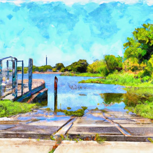
This boat ramp is a concrete ramp that has a moderate slope, making it easy for boaters to launch their vessels. It is also a dual-lane ramp that is wide enough to accommodate two boats at once. The boat ramp is said to be well-maintained, and boaters can launch their boats with ease.
Ripple Creek Lane Boat Ramp services Somerville Lake, which is a reservoir located in the northeastern part of the county. The lake is a popular destination for fishing, boating, and camping. The lake covers an area of approximately 11,000 acres, and it has a maximum depth of 38 feet.
Regarding the kind of craft permitted on the water, Somerville Lake allows all types of watercraft, including jet skis, sailboats, pontoon boats, and bass boats. However, the lake has specific rules and regulations that boaters must follow. For instance, all boats must have a valid registration, and all operators must have a valid boating license. Boaters are also required to observe the posted speed limits, and they must always wear life vests while on the water.
In conclusion, Ripple Creek Lane Boat Ramp is a well-maintained concrete dual-lane ramp that services Somerville Lake in Burleson County, Texas. The boat ramp is wide enough to accommodate two boats at once, and it allows all types of watercraft, including jet skis, sailboats, pontoon boats, and bass boats.
Plan your launch down to the hour
Same weather feed Snoflo's iOS app uses -- updated continuously from NOAA / yr.no.
Next 5 days, hour by hour
Temperature line with weather symbols on top, snow + rain accumulation as columns, humidity as a dotted line.
5-day forecast table
Every 3 hours, broken out across temperature, snow, rain, humidity, and wind.
| Time | Condition | Temp (°F) | Snow (in) | Rain (in) | Humidity (%) | Wind (mps) | Wind dir |
|---|---|---|---|---|---|---|---|
| Loading detailed forecast… | |||||||
15-day temperature & precipitation
Daily temperatures, snow, and rain projected over the next two weeks.
Area streamflow levels
USGS streamgauges around Ripple Creek Lane, Somerville -- the same readings that determine whether your launch is safe and your boat is the right craft.
| Streamgauge | Discharge | View |
|---|---|---|
| Yegua Ck Nr Somerville | 504 cfs | → |
| Davidson Ck Nr Lyons | 2 cfs | → |
| E Yegua Ck Nr Dime Box | 1 cfs | → |
| Middle Yegua Ck Nr Dime Box | 0 cfs | → |
| Brazos Rv At Sh 21 Nr Bryan | 1,260 cfs | → |
| Bee Ck Trib A At College Station | 0 cfs | → |
Plan a longer trip
The closest paddle runs, fishing spots, and other boat launches so you can extend a day on the water.
Boating safety & etiquette
- Check the conditions before you launch
- Use the streamflow numbers, weather, and wind forecast on this page. High-cfs whitewater requires whitewater-specific craft and skill.
- Wear your life jacket
- Statistically the single biggest survival factor in a boating incident. State law often requires one per passenger.
- File a float plan
- Tell someone on shore your put-in, take-out, and expected return time. Especially for multi-day or remote trips.
- Yield at the ramp
- Prep gear in the parking lot, not on the ramp. Launch and clear quickly so others can use the lane.
- Clean, drain, dry
- Inspect, clean, drain and dry your boat between waters to prevent the spread of aquatic invasive species.
Set push alerts in the Snoflo app
Save Ripple Creek Lane, Somerville as a favorite, set a discharge threshold or a wind/precipitation alert, and the iOS app will push the moment conditions cross.
About Ripple Creek Lane, Somerville
Can I launch a motorboat here?
Most Snoflo-tracked launches support motorboats; check the operator for any horsepower restrictions, paddle-only zones, or seasonal closures.
How fresh is the streamflow data?
USGS streamgauges report continuously (every 15 minutes); the table on this page pulls the latest reading at page load.
Is there a fee?
Many federal and state boat launches charge a day-use fee. Check the operator's site before driving out.
What boat is right for these conditions?
Use the nearby streamflow numbers and river-run panel on this page to gauge current conditions. Wider, slower water is friendly for casual paddling and powerboats; high-cfs whitewater requires whitewater-specific craft and skill.
Can I get alerts when conditions change?
Yes -- alerts are managed in the Snoflo iOS app. Favorite this launch, set a threshold (discharge, wind), and you'll get a push the moment it crosses.
Other launches near here
Snoflo-tracked boat launches within driving distance of Ripple Creek Lane, Somerville.