

177th Avenue Kp North 3300, Lakebay Boat Launch Report
Last Updated: May 3, 2026
Leave a Rating°F
°F
mph
Wind
%
Humidity
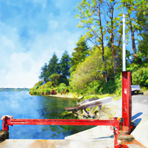
According to the latest information available, the boat ramp located at 177th Avenue Kp North 3300, Lakebay, Washington is a public boat ramp that provides access to the Key Peninsula South area of the Puget Sound.
Summary
The ramp is approximately 16 feet wide and has a moderate slope, which makes it suitable for most types of watercraft, including boats, kayaks, canoes, and paddleboards.
The boat ramp provides access to the Puget Sound, which is a large body of water that stretches from the Strait of Juan de Fuca in the north to Olympia in the south. The Puget Sound is a popular destination for boating, fishing, and other recreational activities, and it is home to a diverse range of marine life, including salmon, orcas, and seals.
According to the latest information available, there are no restrictions on the types of watercraft that are permitted on the Puget Sound, although boaters are advised to check local regulations and weather conditions before setting out on the water. Additionally, boaters are required to carry all necessary safety equipment, such as life jackets, fire extinguishers, and distress signals, and to adhere to all boating laws and regulations.
15-Day Long Term Forecast
 177th Avenue Kp North 3300, Lakebay
5-Day Hourly Forecast Detail
Area Streamflow Levels
River Runs
-
 Brothers Wilderness Boundary To Olympic Nf Boundary
-
 Headwaters- Includes All Tributaries To Confluence With North Fork Skokomish River
-
 Headwaters To Confluence With North Fork Skokomish River
-
 Olympic Nf/Olympic Np Bounary To Brothers Wilderness Boundary
-
 Headwaters- Includes All Tributaries To Confluence With Duckabush River