Apple Capitol Recreational Loop Trail, Wenatchee Boat Launch
Community Reviews
Been here? Share the conditions.
Reviews, ratings & photos are added in the free Snoflo iOS app — rate a spot, tag the conditions, and your visit is verified by location. Add or manage your reviews from the app.
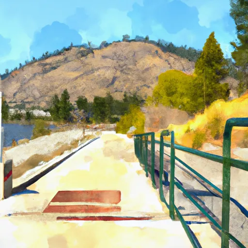
Apple Capitol Recreational Loop Trail, Wenatchee
According to the latest information available on the official website of the Washington Department of Fish and Wildlife, the Apple Capitol Recreational Loop Trail boat ramp is open year-round and allows for the launching of motorized and non-motorized boats, including canoes, kayaks, jet skis, and fishing boats. However, it is important to note that specific restrictions or regulations may apply depending on the type of craft and the time of year. Therefore, users are advised to check with the local authorities or the Department of Fish and Wildlife before using the ramp.
Overall, the Apple Capitol Recreational Loop Trail boat ramp is a popular destination for boaters and water enthusiasts in the Wenatchee area, offering easy access to the Columbia River and various recreational activities such as fishing, water skiing, and wildlife watching.
Plan your launch down to the hour
Same weather feed Snoflo's iOS app uses -- updated continuously from NOAA / yr.no.
Next 5 days, hour by hour
Temperature line with weather symbols on top, snow + rain accumulation as columns, humidity as a dotted line.
5-day forecast table
Every 3 hours, broken out across temperature, snow, rain, humidity, and wind.
| Time | Condition | Temp (°F) | Snow (in) | Rain (in) | Humidity (%) | Wind (mps) | Wind dir |
|---|---|---|---|---|---|---|---|
| Loading detailed forecast… | |||||||
15-day temperature & precipitation
Daily temperatures, snow, and rain projected over the next two weeks.
Area streamflow levels
USGS streamgauges around Apple Capitol Recreational Loop Trail, Wenatchee -- the same readings that determine whether your launch is safe and your boat is the right craft.
| Streamgauge | Discharge | View |
|---|---|---|
| Wenatchee River At Monitor | 965 cfs | → |
| Entiat River Near Entiat | 182 cfs | → |
| Wenatchee River At Peshastin | 986 cfs | → |
| Icicle Creek Above Snow Creek Near Leavenworth | 199 cfs | → |
| Mad River At Ardenvoir | 21 cfs | → |
| Entiat River Near Ardenvoir | 158 cfs | → |
Plan a longer trip
The closest paddle runs, fishing spots, and other boat launches so you can extend a day on the water.
River runs
- Douglas Creek
- Outlet Of Lake Wenatchee To Wenatchee Nf Boundary
- Alpine Lakes Wilderness Boundary To City Of Leavenworth Water Intake In Se1/4 Of Sec 28, T24n, R17e
- Glacier Peak Wilderness Boundary To Confluence With Wenatchee River
- Rock Island Campground To Ida Creek
- Headwaters At Josephine Lake To Alpine Lakes Wilderness Boundary
Boating safety & etiquette
- Check the conditions before you launch
- Use the streamflow numbers, weather, and wind forecast on this page. High-cfs whitewater requires whitewater-specific craft and skill.
- Wear your life jacket
- Statistically the single biggest survival factor in a boating incident. State law often requires one per passenger.
- File a float plan
- Tell someone on shore your put-in, take-out, and expected return time. Especially for multi-day or remote trips.
- Yield at the ramp
- Prep gear in the parking lot, not on the ramp. Launch and clear quickly so others can use the lane.
- Clean, drain, dry
- Inspect, clean, drain and dry your boat between waters to prevent the spread of aquatic invasive species.
Set push alerts in the Snoflo app
Save Apple Capitol Recreational Loop Trail, Wenatchee as a favorite, set a discharge threshold or a wind/precipitation alert, and the iOS app will push the moment conditions cross.
About Apple Capitol Recreational Loop Trail, Wenatchee
Can I launch a motorboat here?
Most Snoflo-tracked launches support motorboats; check the operator for any horsepower restrictions, paddle-only zones, or seasonal closures.
How fresh is the streamflow data?
USGS streamgauges report continuously (every 15 minutes); the table on this page pulls the latest reading at page load.
Is there a fee?
Many federal and state boat launches charge a day-use fee. Check the operator's site before driving out.
What boat is right for these conditions?
Use the nearby streamflow numbers and river-run panel on this page to gauge current conditions. Wider, slower water is friendly for casual paddling and powerboats; high-cfs whitewater requires whitewater-specific craft and skill.
Can I get alerts when conditions change?
Yes -- alerts are managed in the Snoflo iOS app. Favorite this launch, set a threshold (discharge, wind), and you'll get a push the moment it crosses.
Other launches near here
Snoflo-tracked boat launches within driving distance of Apple Capitol Recreational Loop Trail, Wenatchee.