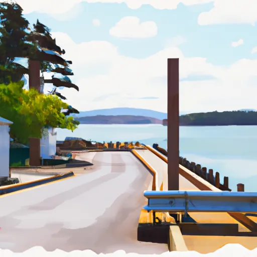
Boat Launch Road, Anacortes Boat Launch
Community Reviews
Been here? Share the conditions.
Reviews, ratings & photos are added in the free Snoflo iOS app — rate a spot, tag the conditions, and your visit is verified by location. Add or manage your reviews from the app.
Boat Launch Road, Anacortes
Boat Launch Road provides access to Fidalgo Bay, a large body of water that is part of the Puget Sound. The bay is popular for boating, fishing, and other water activities. The waters of Fidalgo Bay are generally calm, making it an ideal location for small boats, kayaks, and paddleboards.
The boat ramp at Boat Launch Road is suitable for a wide range of watercraft, including powerboats, sailboats, kayaks, canoes, and other small boats. However, the ramp is not suitable for larger boats, such as those with deep drafts or large motors.
In terms of the latest information available, the Washington State Parks and Recreation Commission maintains a website that provides up-to-date information on boat ramps in the state. According to their website, the boat ramp at Boat Launch Road is currently open and available for use.
Plan your launch down to the hour
Same weather feed Snoflo's iOS app uses -- updated continuously from NOAA / yr.no.
Next 5 days, hour by hour
Temperature line with weather symbols on top, snow + rain accumulation as columns, humidity as a dotted line.
5-day forecast table
Every 3 hours, broken out across temperature, snow, rain, humidity, and wind.
| Time | Condition | Temp (°F) | Snow (in) | Rain (in) | Humidity (%) | Wind (mps) | Wind dir |
|---|---|---|---|---|---|---|---|
| Loading detailed forecast… | |||||||
15-day temperature & precipitation
Daily temperatures, snow, and rain projected over the next two weeks.
Area streamflow levels
USGS streamgauges around Boat Launch Road, Anacortes -- the same readings that determine whether your launch is safe and your boat is the right craft.
| Streamgauge | Discharge | View |
|---|---|---|
| Skagit River Near Mount Vernon | 11,200 cfs | → |
| Samish River Near Burlington | 26 cfs | → |
| Brannian Creek At S Bay Dr Nr Wickersham | 0 cfs | → |
| Anderson Creek Near Bellingham | 1 cfs | → |
| Olsen Creek Near Bellingham | 0 cfs | → |
| Carpenter Creek At N Shore Drive Nr Bellingham | 0 cfs | → |
Plan a longer trip
The closest paddle runs, fishing spots, and other boat launches so you can extend a day on the water.
River runs
- Canyon Creek To Confluence With North Fork Stillaguamish River
- Fish Hatchery To Confluence With South Fork Nooksack River
- Bell Creek To Mt. Baker-Snoqualmie Nf Boundary
- Headwaters To Confluence With Bell Creek
- Headwaters In Ne1/4 Of Sec 23, T37n, R7e To Confluence With Soufh Fork Nooksack River
Boating safety & etiquette
- Check the conditions before you launch
- Use the streamflow numbers, weather, and wind forecast on this page. High-cfs whitewater requires whitewater-specific craft and skill.
- Wear your life jacket
- Statistically the single biggest survival factor in a boating incident. State law often requires one per passenger.
- File a float plan
- Tell someone on shore your put-in, take-out, and expected return time. Especially for multi-day or remote trips.
- Yield at the ramp
- Prep gear in the parking lot, not on the ramp. Launch and clear quickly so others can use the lane.
- Clean, drain, dry
- Inspect, clean, drain and dry your boat between waters to prevent the spread of aquatic invasive species.
Set push alerts in the Snoflo app
Save Boat Launch Road, Anacortes as a favorite, set a discharge threshold or a wind/precipitation alert, and the iOS app will push the moment conditions cross.
About Boat Launch Road, Anacortes
Can I launch a motorboat here?
Most Snoflo-tracked launches support motorboats; check the operator for any horsepower restrictions, paddle-only zones, or seasonal closures.
How fresh is the streamflow data?
USGS streamgauges report continuously (every 15 minutes); the table on this page pulls the latest reading at page load.
Is there a fee?
Many federal and state boat launches charge a day-use fee. Check the operator's site before driving out.
What boat is right for these conditions?
Use the nearby streamflow numbers and river-run panel on this page to gauge current conditions. Wider, slower water is friendly for casual paddling and powerboats; high-cfs whitewater requires whitewater-specific craft and skill.
Can I get alerts when conditions change?
Yes -- alerts are managed in the Snoflo iOS app. Favorite this launch, set a threshold (discharge, wind), and you'll get a push the moment it crosses.
Other launches near here
Snoflo-tracked boat launches within driving distance of Boat Launch Road, Anacortes.