Point Whitney Road 1099, Brinnon Boat Launch
Community Reviews
Been here? Share the conditions.
Reviews, ratings & photos are added in the free Snoflo iOS app — rate a spot, tag the conditions, and your visit is verified by location. Add or manage your reviews from the app.
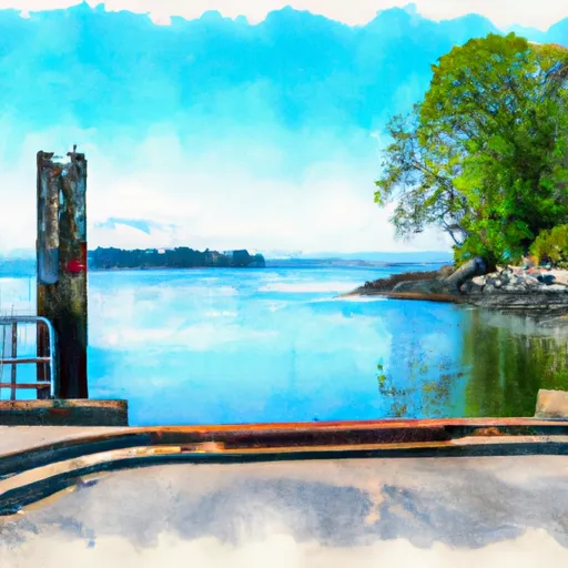
Point Whitney Road 1099, Brinnon
The Point Whitney Road 1099 boat ramp is designed to accommodate a variety of watercraft, including powerboats, sailboats, kayaks, and canoes. However, it is important to note that motorized vessels must adhere to a strict speed limit of 7 knots within 200 feet of the shoreline. Additionally, the use of personal watercraft (such as jet skis) is prohibited in this area.
Overall, the Point Whitney Road 1099 boat ramp is a valuable resource for boaters in the Brinnon area, providing easy access to the scenic waters of Hood Canal. Boaters should always exercise caution and follow all regulations to ensure a safe and enjoyable experience on the water.
Plan your launch down to the hour
Same weather feed Snoflo's iOS app uses -- updated continuously from NOAA / yr.no.
Next 5 days, hour by hour
Temperature line with weather symbols on top, snow + rain accumulation as columns, humidity as a dotted line.
5-day forecast table
Every 3 hours, broken out across temperature, snow, rain, humidity, and wind.
| Time | Condition | Temp (°F) | Snow (in) | Rain (in) | Humidity (%) | Wind (mps) | Wind dir |
|---|---|---|---|---|---|---|---|
| Loading detailed forecast… | |||||||
15-day temperature & precipitation
Daily temperatures, snow, and rain projected over the next two weeks.
Area streamflow levels
USGS streamgauges around Point Whitney Road 1099, Brinnon -- the same readings that determine whether your launch is safe and your boat is the right craft.
| Streamgauge | Discharge | View |
|---|---|---|
| Big Quilcene River Below Diversion Nr Quilcene | 27 cfs | → |
| Duckabush River Near Brinnon | 52 cfs | → |
| Dungeness River Near Sequim | 116 cfs | → |
| Huge Creek Near Wauna | 5 cfs | → |
| Thornton Creek Near Seattle | 41 cfs | → |
| Nf Skokomish R Bl Staircase Rpds Nr Hoodsport | 46 cfs | → |
Plan a longer trip
The closest paddle runs, fishing spots, and other boat launches so you can extend a day on the water.
River runs
- Brothers Wilderness Boundary To Olympic Nf Boundary
- Olympic Nf/Olympic Np Bounary To Brothers Wilderness Boundary
- Headwaters- Includes All Tributaries To Confluence With Dosewallips River
- Headwaters- Includes All Tributaries (Upstream From Station Creek) To Confluence With Dosewallips River
Boating safety & etiquette
- Check the conditions before you launch
- Use the streamflow numbers, weather, and wind forecast on this page. High-cfs whitewater requires whitewater-specific craft and skill.
- Wear your life jacket
- Statistically the single biggest survival factor in a boating incident. State law often requires one per passenger.
- File a float plan
- Tell someone on shore your put-in, take-out, and expected return time. Especially for multi-day or remote trips.
- Yield at the ramp
- Prep gear in the parking lot, not on the ramp. Launch and clear quickly so others can use the lane.
- Clean, drain, dry
- Inspect, clean, drain and dry your boat between waters to prevent the spread of aquatic invasive species.
Set push alerts in the Snoflo app
Save Point Whitney Road 1099, Brinnon as a favorite, set a discharge threshold or a wind/precipitation alert, and the iOS app will push the moment conditions cross.
About Point Whitney Road 1099, Brinnon
Can I launch a motorboat here?
Most Snoflo-tracked launches support motorboats; check the operator for any horsepower restrictions, paddle-only zones, or seasonal closures.
How fresh is the streamflow data?
USGS streamgauges report continuously (every 15 minutes); the table on this page pulls the latest reading at page load.
Is there a fee?
Many federal and state boat launches charge a day-use fee. Check the operator's site before driving out.
What boat is right for these conditions?
Use the nearby streamflow numbers and river-run panel on this page to gauge current conditions. Wider, slower water is friendly for casual paddling and powerboats; high-cfs whitewater requires whitewater-specific craft and skill.
Can I get alerts when conditions change?
Yes -- alerts are managed in the Snoflo iOS app. Favorite this launch, set a threshold (discharge, wind), and you'll get a push the moment it crosses.
Other launches near here
Snoflo-tracked boat launches within driving distance of Point Whitney Road 1099, Brinnon.