Spring Mill State Park Campground
Community Reviews
Been here? Share the conditions.
Reviews, ratings & photos are added in the free Snoflo iOS app — rate a spot, tag the conditions, and your visit is verified by location. Add or manage your reviews from the app.
Spring Mill State Park
Reservations are accepted at Spring Mill State Park, ensuring that you can secure a spot during the peak season. It is recommended to make a reservation in advance, especially if you plan to visit during weekends or holidays. The best time to visit the campground is during the spring and fall seasons when the weather is mild and enjoyable for outdoor activities.
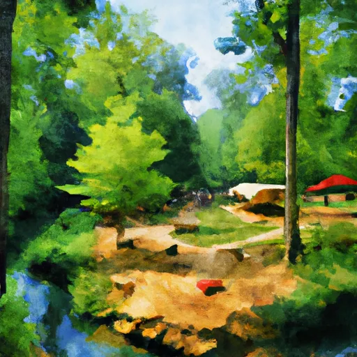
Spring Mill State Park offers numerous attractions for campers to explore. One of the highlights is the historical Pioneer Village, where visitors can step back in time and experience life in the 1800s. The park also features a fascinating cave system, which can be explored through guided tours. Nature enthusiasts will enjoy hiking trails that wind through forests, past waterfalls, and along creeks.
While enjoying your camping trip, it is important to be cautious of wildlife encounters and follow park regulations for your safety. Additionally, make sure to pack insect repellent, as mosquitoes can be abundant in the area during certain times of the year. Overall, Spring Mill State Park camping area provides a fantastic outdoor experience with its amenities, historical attractions, and natural beauty.
What's on-site at Spring Mill State Park
Key facilities Snoflo tracks for this campground. Confirm with the operator before booking -- amenities can change seasonally.
Plan your trip down to the hour
Same weather feed Snoflo's iOS app uses -- updated continuously from NOAA / yr.no.
Next 5 days, hour by hour
Temperature line with weather symbols on top, snow + rain accumulation as columns, humidity as a dotted line.
5-day forecast table
Every 3 hours, broken out across temperature, snow, rain, humidity, and wind. Each cell is colour-coded relative to the column min/max so trends jump out at a glance.
| Time | Condition | Temp (°F) | Snow (in) | Rain (in) | Humidity (%) | Wind (mps) | Wind dir |
|---|---|---|---|---|---|---|---|
| Loading detailed forecast… | |||||||
15-day temperature & precipitation
Daily temperatures, snow, and rain projected over the next two weeks. Hover any point for the full breakdown.
Other campgrounds in the area
Snoflo-tracked campsites within driving distance of Spring Mill State Park, with reservations status.
| Campground | Reservations | Toilets | View |
|---|---|---|---|
| Campground | ✗ | ✗ | → |
| Stone Creek Campground & Trails | ✗ | ✗ | → |
| Martin State Forest | ✗ | ✗ | → |
| Harden's Horse Camp | ✗ | ✗ | → |
Nearby streamflow
USGS streamgauges within reach of Spring Mill State Park -- pulled live from the National Water Information System.
| Streamgauge | Discharge | View |
|---|---|---|
| East Fork White River Near Bedford | 1,280 cfs | → |
| West Fork Blue River At Salem | 3 cfs | → |
| East Fork White River At Shoals | 3,980 cfs | → |
| Blue River At Fredericksburg | 67 cfs | → |
| East Fork White River At Seymour Ind | 819 cfs | → |
| Patoka River At Jasper | 323 cfs | → |
Nearby snow depths
NRCS SNOTEL stations within reach of Spring Mill State Park -- relevant when planning a shoulder-season or alpine trip.
| SNOTEL station | Snowpack | 24h Snowfall | View |
|---|---|---|---|
| Campbellsburg 8.4 Nne | 0.0 in | 0.0 in | → |
| Bloomfield Waterworks | 0.0 in | 0.0 in | → |
| Elnora | 0.0 in | 0.0 in | → |
| Columbus Wastewater Treatment Plant | 0.0 in | 0.0 in | → |
| Washington 1.5 Nw | 0.0 in | 0.0 in | → |
| Huntingburg 0.4 Ssw | 0.0 in | 0.0 in | → |
Plan a longer trip
The closest parks, lakes, boat launches, and paddle runs so a camping night can grow into a full weekend.
Parks
- Spring Mill State Park
- Rivervale Church Park
- Thornton Park
- Murray Forest Park
- Pioneer Mothers Memorial Forest
- Wilderness Charles C. Deam
Boat launches
- Lawrenceport
- Bedford
- Medora
- East Delaney Millport Road 76, Vallonia
- South Co Road 550 West 3941-4299, Paoli
- Jackson County
Fishing spots
Points of interest
Paddle runs
- Junction Of North/South Forks Of Lost River To State Road 337 Bridge, Approx 4 Miles Southeast Of Orleans, In
- State Road 337 Bridge To State Road 56 Bridge At Prospect, In
- State Road 56 Bridge To Forest Purchase Boundary At Roland, In
- City Limits Of English, In To Carnes Mill Site In Ne1/4ne1/4 Of Sec 13, T3s, R1w
- Carnes Mill Site To 7.65 Miles Above Confluece With Ohio River At Confluence With Turkey Creek
Camping essentials & Leave No Trace
- Pack it in, pack it out
- Take all trash, food scraps, and gear back with you to keep campsites clean and protect wildlife.
- Respect wildlife
- Observe animals from a distance, store food securely, and never feed wildlife to maintain natural behavior and safety.
- Know before you go
- Check weather, fire restrictions, trail conditions, and permit requirements to ensure a safe and well-planned trip.
- Minimize campfire impact
- Use established fire rings, keep fires small, fully extinguish them, or opt for a camp stove when fires are restricted.
- Leave what you find
- Preserve natural and cultural features by avoiding removal of plants, rocks, artifacts, or other elements of the environment.
Set push alerts in the Snoflo app
Save Spring Mill State Park as a favorite, set a custom threshold (precipitation, snowpack, freezing temperatures), and the iOS app will push the moment conditions cross.
About Spring Mill State Park
Can I make reservations at Spring Mill State Park?
Yes -- this campground accepts reservations. Snoflo recommends booking early for peak season; check the operator (Recreation.gov / state park system / private operator) for the booking window and cancellation policy.
How fresh is the weather data on this page?
The hourly forecast updates throughout the day from the NOAA / yr.no public feeds. Streamflow data is pulled live from USGS streamgauges and snowpack from the NRCS SNOTEL network.
What's the best time of year to visit?
Use the 15-day temperature & precipitation outlook on this page to plan -- pick a window with comfortable temperatures and low precipitation. For longer trips, the 5-day hourly meteogram shows snow + rain accumulation hour-by-hour.
How do I get to Spring Mill State Park?
Tap Directions in the hero above to open driving directions in Google Maps, or Open in map to center the Snoflo interactive map on the campground.
Can I get alerts when conditions change?
Yes -- alerts are managed through the Snoflo iOS app. Favorite this campground, set a threshold (temperature, snowpack, precipitation), and you'll get a push the moment it crosses.
Other campgrounds near here
Snoflo-tracked campgrounds within driving distance of Spring Mill State Park.