De Motte campground
Community Reviews
Been here? Share the conditions.
Reviews, ratings & photos are added in the free Snoflo iOS app — rate a spot, tag the conditions, and your visit is verified by location. Add or manage your reviews from the app.
De Motte
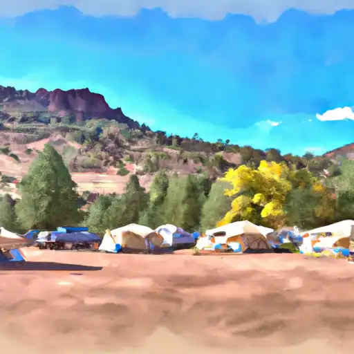
Reservations are not accepted at De Motte camping area, making it a first-come, first-served campground. Therefore, it is recommended to arrive early to secure a campsite, especially during peak seasons. The best time to visit this area is in the spring and fall, as the weather is pleasant and the campground is less crowded.
While staying at De Motte camping area, visitors can explore the surrounding attractions and activities. The nearby Kaibab National Forest offers numerous hiking trails, allowing campers to immerse themselves in the natural beauty of the area. It is advised to be cautious of wildlife encounters, as the campground is located in a wildlife-rich region. Proper food storage techniques and respecting the wildlife's natural habitat are crucial for a safe and enjoyable camping experience.
In summary, De Motte camping area in Arizona provides a serene camping experience with amenities such as picnic tables, fire rings, vault toilets, and potable water. Reservations are not accepted, so arriving early is recommended. The best time to visit is during the spring and fall. While exploring the area, campers can enjoy hiking trails in the Kaibab National Forest, but should remain cautious of wildlife encounters.
What's on-site at De Motte
Key facilities Snoflo tracks for this campground. Confirm with the operator before booking -- amenities can change seasonally.
Plan your trip down to the hour
Same weather feed Snoflo's iOS app uses -- updated continuously from NOAA / yr.no.
Next 5 days, hour by hour
Temperature line with weather symbols on top, snow + rain accumulation as columns, humidity as a dotted line.
5-day forecast table
Every 3 hours, broken out across temperature, snow, rain, humidity, and wind. Each cell is colour-coded relative to the column min/max so trends jump out at a glance.
| Time | Condition | Temp (°F) | Snow (in) | Rain (in) | Humidity (%) | Wind (mps) | Wind dir |
|---|---|---|---|---|---|---|---|
| Loading detailed forecast… | |||||||
15-day temperature & precipitation
Daily temperatures, snow, and rain projected over the next two weeks. Hover any point for the full breakdown.
Other campgrounds in the area
Snoflo-tracked campsites within driving distance of De Motte, with reservations status.
| Campground | Reservations | Toilets | View |
|---|---|---|---|
| Demotte Campground | ✗ | ✗ | → |
| De Motte Campground (Usfs) | ✗ | ✗ | → |
| Kaibab National Forest Free Campsite | ✗ | ✗ | → |
| Duck N Quack Camp | ✗ | ✗ | → |
| Upper Saddle Camp | ✗ | ✗ | → |
Nearby streamflow
USGS streamgauges within reach of De Motte -- pulled live from the National Water Information System.
| Streamgauge | Discharge | View |
|---|---|---|
| Colorado River Near Grand Canyon | 8,080 cfs | → |
| Little Colorado River Abv Mouth Nr Desert View | 215 cfs | → |
| Kanab Creek Abv Mouth Nr Supai | 5 cfs | → |
| Havasu Creek At Supai | 76 cfs | → |
| Havasu Creek Abv Mouth Nr Supai | 66 cfs | → |
| Colorado River At Lees Ferry | 9,060 cfs | → |
Nearby snow depths
NRCS SNOTEL stations within reach of De Motte -- relevant when planning a shoulder-season or alpine trip.
| SNOTEL station | Snowpack | 24h Snowfall | View |
|---|---|---|---|
| Grand Canyon East Entrance | 0.0 in | 0.0 in | → |
Plan a longer trip
The closest parks, lakes, boat launches, and paddle runs so a camping night can grow into a full weekend.
Parks
Points of interest
- The Blowdown
- East Rim Viewpoint
- Dog Canyon Apron
- Monument Viewpoint
- Timp & North Timp Viewpoints
- Mystic Falls
Paddle runs
- Headwaters To Confluence With The Colorado River
- Headwaters At South Canyon Spring To Confluence With The Colorado River
- Headwaters To Confluence With Bright Angel Creek
- Greenland Spring (Elev. 8000') To Confluence With The Colorado River
- Confluence With White Creek To Confluence With The Colorado River
Camping essentials & Leave No Trace
- Pack it in, pack it out
- Take all trash, food scraps, and gear back with you to keep campsites clean and protect wildlife.
- Respect wildlife
- Observe animals from a distance, store food securely, and never feed wildlife to maintain natural behavior and safety.
- Know before you go
- Check weather, fire restrictions, trail conditions, and permit requirements to ensure a safe and well-planned trip.
- Minimize campfire impact
- Use established fire rings, keep fires small, fully extinguish them, or opt for a camp stove when fires are restricted.
- Leave what you find
- Preserve natural and cultural features by avoiding removal of plants, rocks, artifacts, or other elements of the environment.
Set push alerts in the Snoflo app
Save De Motte as a favorite, set a custom threshold (precipitation, snowpack, freezing temperatures), and the iOS app will push the moment conditions cross.
About De Motte
Can I make reservations at De Motte?
This campground does not appear to accept reservations -- it's typically first-come, first-served. Arrive early on summer weekends.
How fresh is the weather data on this page?
The hourly forecast updates throughout the day from the NOAA / yr.no public feeds. Streamflow data is pulled live from USGS streamgauges and snowpack from the NRCS SNOTEL network.
What's the best time of year to visit?
Use the 15-day temperature & precipitation outlook on this page to plan -- pick a window with comfortable temperatures and low precipitation. For longer trips, the 5-day hourly meteogram shows snow + rain accumulation hour-by-hour.
How do I get to De Motte?
Tap Directions in the hero above to open driving directions in Google Maps, or Open in map to center the Snoflo interactive map on the campground.
Can I get alerts when conditions change?
Yes -- alerts are managed through the Snoflo iOS app. Favorite this campground, set a threshold (temperature, snowpack, precipitation), and you'll get a push the moment it crosses.
Other campgrounds near here
Snoflo-tracked campgrounds within driving distance of De Motte.