Blanchard Springs Campgrounds Campground
Community Reviews
Been here? Share the conditions.
Reviews, ratings & photos are added in the free Snoflo iOS app — rate a spot, tag the conditions, and your visit is verified by location. Add or manage your reviews from the app.
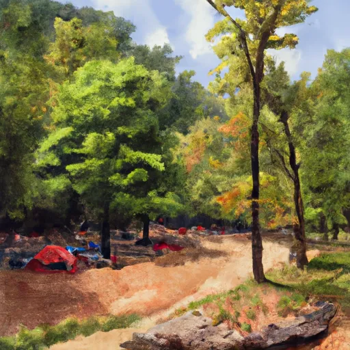
Blanchard Springs Campgrounds
Reservations are accepted at Blanchard Springs Campgrounds, allowing campers to secure their preferred site in advance. It is advisable to make reservations, especially during peak seasons, to ensure availability. The best time to visit this camping area is in the spring and fall, when the weather is pleasant and the foliage is vibrant. However, it is important to note that the campground is closed during the winter months.
While exploring Blanchard Springs Campgrounds, campers can discover several points of interest. One highlight is the Blanchard Springs Caverns, an incredible underground cave system that offers guided tours for visitors. This natural wonder offers a unique opportunity to witness stunning rock formations and learn about the geology of the area. Additionally, the Sylamore Creek, located nearby, provides opportunities for swimming, fishing, and kayaking. Campers should be cautious of wildlife in the area, including bears and snakes, and take necessary precautions to ensure their safety.
In conclusion, Blanchard Springs Campgrounds in Arkansas offers a well-equipped camping area with amenities such as picnic tables, fire rings, and access to potable water. Reservations are accepted, and the best time to visit is in the spring and fall. Visitors can explore the breathtaking Blanchard Springs Caverns and enjoy recreational activities in the nearby Sylamore Creek. Stay mindful of wildlife and safety precautions while enjoying the beauty of this campground.
What's on-site at Blanchard Springs Campgrounds
Key facilities Snoflo tracks for this campground. Confirm with the operator before booking -- amenities can change seasonally.
Plan your trip down to the hour
Same weather feed Snoflo's iOS app uses -- updated continuously from NOAA / yr.no.
Next 5 days, hour by hour
Temperature line with weather symbols on top, snow + rain accumulation as columns, humidity as a dotted line.
5-day forecast table
Every 3 hours, broken out across temperature, snow, rain, humidity, and wind. Each cell is colour-coded relative to the column min/max so trends jump out at a glance.
| Time | Condition | Temp (°F) | Snow (in) | Rain (in) | Humidity (%) | Wind (mps) | Wind dir |
|---|---|---|---|---|---|---|---|
| Loading detailed forecast… | |||||||
15-day temperature & precipitation
Daily temperatures, snow, and rain projected over the next two weeks. Hover any point for the full breakdown.
Other campgrounds in the area
Snoflo-tracked campsites within driving distance of Blanchard Springs Campgrounds, with reservations status.
| Campground | Reservations | Toilets | View |
|---|---|---|---|
| Blanchard Springs | ✗ | ✗ | → |
| Gunner Pool Recreation Area | ✗ | ✗ | → |
| Gunner Pool | ✗ | ✗ | → |
| Barkshed | ✗ | ✗ | → |
| Barkshed Recreation Area | ✗ | ✗ | → |
Nearby streamflow
USGS streamgauges within reach of Blanchard Springs Campgrounds -- pulled live from the National Water Information System.
| Streamgauge | Discharge | View |
|---|---|---|
| North Sylamore Creek Near Fifty Six | 8 cfs | → |
| White River At Calico Rock | 6,940 cfs | → |
| White River Near Norfork | 13,200 cfs | → |
| Buffalo River Near Harriet | 270 cfs | → |
| Middle Fork Of Little Red River At Shirley | 78 cfs | → |
| South Fork Of Little Red River At Clinton | 9 cfs | → |
Nearby snow depths
NRCS SNOTEL stations within reach of Blanchard Springs Campgrounds -- relevant when planning a shoulder-season or alpine trip.
| SNOTEL station | Snowpack | 24h Snowfall | View |
|---|---|---|---|
| Jordan 3nnw | 0.0 in | 0.0 in | → |
| Gilbert | 0.0 in | 0.0 in | → |
| Heber Springs 2ne | 0.0 in | 0.0 in | → |
| Batesville L&D 1 | 0.0 in | 0.0 in | → |
| Damascus 2 Nne | 0.0 in | 0.0 in | → |
| Calamine | 0.0 in | 0.0 in | → |
Plan a longer trip
The closest parks, lakes, boat launches, and paddle runs so a camping night can grow into a full weekend.
Parks
- Blanchard Springs Recreation Area
- Sylamore Wildlife Management Area
- Devils Knob Natural Area Wildlife Management Area
- Ozark Folk Center State Park
- Wilderness Leatherwood
- Melbourne Fishing Park
Boat launches
- Ar 5 Stone County
- North Sylamore Creek (East)
- Mount Olive
- Mcphearson Terrace Baxter County
- Highway 58 Bridge
- Red's Landing Lane
Camping essentials & Leave No Trace
- Pack it in, pack it out
- Take all trash, food scraps, and gear back with you to keep campsites clean and protect wildlife.
- Respect wildlife
- Observe animals from a distance, store food securely, and never feed wildlife to maintain natural behavior and safety.
- Know before you go
- Check weather, fire restrictions, trail conditions, and permit requirements to ensure a safe and well-planned trip.
- Minimize campfire impact
- Use established fire rings, keep fires small, fully extinguish them, or opt for a camp stove when fires are restricted.
- Leave what you find
- Preserve natural and cultural features by avoiding removal of plants, rocks, artifacts, or other elements of the environment.
Set push alerts in the Snoflo app
Save Blanchard Springs Campgrounds as a favorite, set a custom threshold (precipitation, snowpack, freezing temperatures), and the iOS app will push the moment conditions cross.
About Blanchard Springs Campgrounds
Can I make reservations at Blanchard Springs Campgrounds?
Yes -- this campground accepts reservations. Snoflo recommends booking early for peak season; check the operator (Recreation.gov / state park system / private operator) for the booking window and cancellation policy.
How fresh is the weather data on this page?
The hourly forecast updates throughout the day from the NOAA / yr.no public feeds. Streamflow data is pulled live from USGS streamgauges and snowpack from the NRCS SNOTEL network.
What's the best time of year to visit?
Use the 15-day temperature & precipitation outlook on this page to plan -- pick a window with comfortable temperatures and low precipitation. For longer trips, the 5-day hourly meteogram shows snow + rain accumulation hour-by-hour.
How do I get to Blanchard Springs Campgrounds?
Tap Directions in the hero above to open driving directions in Google Maps, or Open in map to center the Snoflo interactive map on the campground.
Can I get alerts when conditions change?
Yes -- alerts are managed through the Snoflo iOS app. Favorite this campground, set a threshold (temperature, snowpack, precipitation), and you'll get a push the moment it crosses.
Other campgrounds near here
Snoflo-tracked campgrounds within driving distance of Blanchard Springs Campgrounds.