Buffalo Point D Loop Campground
Community Reviews
Been here? Share the conditions.
Reviews, ratings & photos are added in the free Snoflo iOS app — rate a spot, tag the conditions, and your visit is verified by location. Add or manage your reviews from the app.
Buffalo Point D Loop
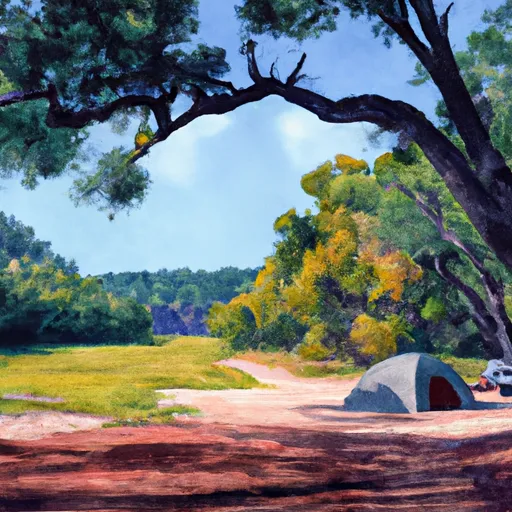
The immediate surroundings of the Buffalo Point D Loop Camping Area are breathtaking. The campsite is situated in a valley, surrounded by the Ozark Mountains, which offer a stunning view of the surrounding area. The area is also home to a diverse range of wildlife, including elk, deer, and numerous bird species.
There are several points of interest near the Buffalo Point D Loop Camping Area, including the Buffalo Point Ranger Station, a nearby canoe rental service, and the Indian Rockhouse Trail. The trail offers breathtaking views of the surrounding area and is a must-visit for hikers. The area is also home to several caves that are open for exploration.
The campground amenities include fire rings, picnic tables, and access to potable water and restrooms. The campground is also pet-friendly and has a designated area for pets. Additionally, the campground provides a dump station and a nearby store for any necessary supplies.
Interesting facts about the area include the Buffalo River being one of the few remaining undammed rivers in the lower 48 states. The river is also known for its excellent fishing, with smallmouth bass being a popular catch. The area also has a rich history, with several prehistoric and historic sites in the surrounding area.
The best time to visit the Buffalo Point D Loop Camping Area is during the fall when the temperatures are mild, and the surrounding area is awash in stunning fall foliage. Average temperatures during this time range from the mid-50s to the mid-70s. However, the campground is open year-round, and visitors can enjoy a variety of outdoor activities during the spring and summer months.
Overall, the Buffalo Point D Loop Camping Area is a must-visit for anyone seeking a peaceful camping experience in the heart of nature. With its stunning views, nearby points of interest, and comfortable amenities, it is an ideal location for any camper seeking to experience the beauty of Arkansas.
What's on-site at Buffalo Point D Loop
Key facilities Snoflo tracks for this campground. Confirm with the operator before booking -- amenities can change seasonally.
Plan your trip down to the hour
Same weather feed Snoflo's iOS app uses -- updated continuously from NOAA / yr.no.
Next 5 days, hour by hour
Temperature line with weather symbols on top, snow + rain accumulation as columns, humidity as a dotted line.
5-day forecast table
Every 3 hours, broken out across temperature, snow, rain, humidity, and wind. Each cell is colour-coded relative to the column min/max so trends jump out at a glance.
| Time | Condition | Temp (°F) | Snow (in) | Rain (in) | Humidity (%) | Wind (mps) | Wind dir |
|---|---|---|---|---|---|---|---|
| Loading detailed forecast… | |||||||
15-day temperature & precipitation
Daily temperatures, snow, and rain projected over the next two weeks. Hover any point for the full breakdown.
Other campgrounds in the area
Snoflo-tracked campsites within driving distance of Buffalo Point D Loop, with reservations status.
| Campground | Reservations | Toilets | View |
|---|---|---|---|
| Buffalo Point E Loop | ✗ | ✗ | → |
| Buffalo Point C Loop | ✗ | ✗ | → |
| Buffalo Point Walk-In Tent Loop | ✗ | ✗ | → |
| Buffalo Point - Buffalo National River | ✓ | ✗ | → |
| Buffalo Point Group Campground | ✗ | ✗ | → |
Nearby streamflow
USGS streamgauges within reach of Buffalo Point D Loop -- pulled live from the National Water Information System.
| Streamgauge | Discharge | View |
|---|---|---|
| Buffalo River Near Harriet | 127 cfs | → |
| Buffalo River Near St. Joe | 80 cfs | → |
| Bear Creek Near Silver Hill | 13 cfs | → |
| White River Near Norfork | 8,220 cfs | → |
| North Sylamore Creek Near Fifty Six | 7 cfs | → |
| White River At Calico Rock | 3,900 cfs | → |
Nearby snow depths
NRCS SNOTEL stations within reach of Buffalo Point D Loop -- relevant when planning a shoulder-season or alpine trip.
| SNOTEL station | Snowpack | 24h Snowfall | View |
|---|---|---|---|
| Gilbert | 0.0 in | 0.0 in | → |
| Jordan 3nnw | 0.0 in | 0.0 in | → |
| Jasper | 0.0 in | 0.0 in | → |
| Damascus 2 Nne | 0.0 in | 0.0 in | → |
Plan a longer trip
The closest parks, lakes, boat launches, and paddle runs so a camping night can grow into a full weekend.
Parks
- Buffalo River State Park
- Lower Buffalo Wilderness Area
- Loafer's Glory Wildlife Management Area
- Wilderness Leatherwood
- State Conservation Area Kelly's Slab
- Bull Shoals-White River State Park
Boat launches
- White Buffalo Lane
- White River Ranchette
- Big Spring Parkway Cotter
- Rim Shoals
- Shipps Ferry Road Baxter County
- Wildcat Shoals
Fishing spots
- Bull Shoals Tailwater
- Gunner Creek
- Little North Fork White River
- Trimble Creek
- Bull Shoals Lake
- Langston Lake
Camping essentials & Leave No Trace
- Pack it in, pack it out
- Take all trash, food scraps, and gear back with you to keep campsites clean and protect wildlife.
- Respect wildlife
- Observe animals from a distance, store food securely, and never feed wildlife to maintain natural behavior and safety.
- Know before you go
- Check weather, fire restrictions, trail conditions, and permit requirements to ensure a safe and well-planned trip.
- Minimize campfire impact
- Use established fire rings, keep fires small, fully extinguish them, or opt for a camp stove when fires are restricted.
- Leave what you find
- Preserve natural and cultural features by avoiding removal of plants, rocks, artifacts, or other elements of the environment.
Set push alerts in the Snoflo app
Save Buffalo Point D Loop as a favorite, set a custom threshold (precipitation, snowpack, freezing temperatures), and the iOS app will push the moment conditions cross.
About Buffalo Point D Loop
Can I make reservations at Buffalo Point D Loop?
This campground does not appear to accept reservations -- it's typically first-come, first-served. Arrive early on summer weekends.
How fresh is the weather data on this page?
The hourly forecast updates throughout the day from the NOAA / yr.no public feeds. Streamflow data is pulled live from USGS streamgauges and snowpack from the NRCS SNOTEL network.
What's the best time of year to visit?
Use the 15-day temperature & precipitation outlook on this page to plan -- pick a window with comfortable temperatures and low precipitation. For longer trips, the 5-day hourly meteogram shows snow + rain accumulation hour-by-hour.
How do I get to Buffalo Point D Loop?
Tap Directions in the hero above to open driving directions in Google Maps, or Open in map to center the Snoflo interactive map on the campground.
Can I get alerts when conditions change?
Yes -- alerts are managed through the Snoflo iOS app. Favorite this campground, set a threshold (temperature, snowpack, precipitation), and you'll get a push the moment it crosses.
Other campgrounds near here
Snoflo-tracked campgrounds within driving distance of Buffalo Point D Loop.