South Fourche Campground
Community Reviews
Been here? Share the conditions.
Reviews, ratings & photos are added in the free Snoflo iOS app — rate a spot, tag the conditions, and your visit is verified by location. Add or manage your reviews from the app.
South Fourche
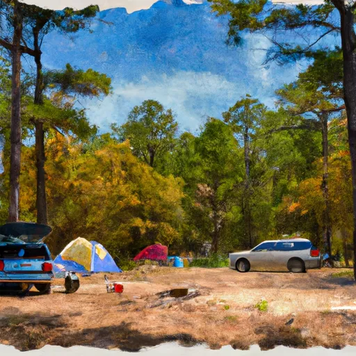
Reservations are accepted at South Fourche camping area, allowing campers to secure their spot in advance. This is particularly beneficial during peak seasons when the campground tends to fill up quickly. It is advisable to make a reservation to ensure availability, especially if planning to visit during holidays or weekends.
The best time to visit South Fourche camping area is during the spring and fall months when the weather is mild and pleasant. Summers can be hot and humid, while winters can be cold. The campground offers a serene environment, surrounded by beautiful scenery and an abundance of nature trails for hiking and exploring. Wildlife enthusiasts will enjoy observing the various species of birds and animals that call this area home.
While camping at South Fourche, it is important to be cautious of wildlife encounters, particularly with black bears. Campers should adhere to proper food storage practices to avoid attracting bears or other wildlife. Additionally, it is essential to follow all campground rules and regulations to ensure the safety and enjoyment of all visitors.
What's on-site at South Fourche
Key facilities Snoflo tracks for this campground. Confirm with the operator before booking -- amenities can change seasonally.
Plan your trip down to the hour
Same weather feed Snoflo's iOS app uses -- updated continuously from NOAA / yr.no.
Next 5 days, hour by hour
Temperature line with weather symbols on top, snow + rain accumulation as columns, humidity as a dotted line.
5-day forecast table
Every 3 hours, broken out across temperature, snow, rain, humidity, and wind. Each cell is colour-coded relative to the column min/max so trends jump out at a glance.
| Time | Condition | Temp (°F) | Snow (in) | Rain (in) | Humidity (%) | Wind (mps) | Wind dir |
|---|---|---|---|---|---|---|---|
| Loading detailed forecast… | |||||||
15-day temperature & precipitation
Daily temperatures, snow, and rain projected over the next two weeks. Hover any point for the full breakdown.
Other campgrounds in the area
Snoflo-tracked campsites within driving distance of South Fourche, with reservations status.
| Campground | Reservations | Toilets | View |
|---|---|---|---|
| Knoppers Ford | ✗ | ✓ | → |
| Jack Creek Recreation Area | ✗ | ✗ | → |
| Big Brushy | ✗ | ✓ | → |
| Outlet Area - Blue Mountain Lake | ✓ | ✓ | → |
| Dragover | ✗ | ✓ | → |
Nearby streamflow
USGS streamgauges within reach of South Fourche -- pulled live from the National Water Information System.
| Streamgauge | Discharge | View |
|---|---|---|
| Fourche Lafave River Near Gravelly | 55 cfs | → |
| Dutch Creek At Waltreak | · | → |
| Ouachita River Near Mount Ida | 71 cfs | → |
| Petit Jean River At Danville | 432 cfs | → |
| Petit Jean River Near Booneville | 52 cfs | → |
| Caddo River Near Caddo Gap | 45 cfs | → |
Plan a longer trip
The closest parks, lakes, boat launches, and paddle runs so a camping night can grow into a full weekend.
Parks
- Dry Creek Wilderness
- Pigeon Creek National Game Refuge
- Muddy Creek Wildlife Management Area
- Ouachita National Wildlife Refuge
- Mount Magazine State Park
- Ad Morris Park
Boat launches
- Lick Creek Recreation Area
- Logan County
- Ashley Creek Recreation Area
- County Road 539 Yell County
- Waveland Park Recreation Area - 3
- Waveland Park Recreation Area - 1
Fishing spots
- Moss Creek
- Big Brushy Creek Day Use
- Blue Mountain Lake
- Dragover Day Use
- Rocky Shoals Day Use
- Truman Baker Lake
Points of interest
Paddle runs
- Highway 298 Bridge Near Sims, Ar To Slackwater Of Lake Ouachita
- Nf Boundary At Pine Ridge, Ar To Highway 298 Bridge Near Sims, Ar
- Sec 30, T3s, R27w To Sec 19, T4s, R24w
- Headwaters In Sec 8, T1s, R31w To Nf Boundary At Acorn, Ar
- Headwaters Sec 2, T1n, R20w To Sec 7, T1n, R19w
Camping essentials & Leave No Trace
- Pack it in, pack it out
- Take all trash, food scraps, and gear back with you to keep campsites clean and protect wildlife.
- Respect wildlife
- Observe animals from a distance, store food securely, and never feed wildlife to maintain natural behavior and safety.
- Know before you go
- Check weather, fire restrictions, trail conditions, and permit requirements to ensure a safe and well-planned trip.
- Minimize campfire impact
- Use established fire rings, keep fires small, fully extinguish them, or opt for a camp stove when fires are restricted.
- Leave what you find
- Preserve natural and cultural features by avoiding removal of plants, rocks, artifacts, or other elements of the environment.
Set push alerts in the Snoflo app
Save South Fourche as a favorite, set a custom threshold (precipitation, snowpack, freezing temperatures), and the iOS app will push the moment conditions cross.
About South Fourche
Can I make reservations at South Fourche?
This campground does not appear to accept reservations -- it's typically first-come, first-served. Arrive early on summer weekends.
How fresh is the weather data on this page?
The hourly forecast updates throughout the day from the NOAA / yr.no public feeds. Streamflow data is pulled live from USGS streamgauges and snowpack from the NRCS SNOTEL network.
What's the best time of year to visit?
Use the 15-day temperature & precipitation outlook on this page to plan -- pick a window with comfortable temperatures and low precipitation. For longer trips, the 5-day hourly meteogram shows snow + rain accumulation hour-by-hour.
How do I get to South Fourche?
Tap Directions in the hero above to open driving directions in Google Maps, or Open in map to center the Snoflo interactive map on the campground.
Can I get alerts when conditions change?
Yes -- alerts are managed through the Snoflo iOS app. Favorite this campground, set a threshold (temperature, snowpack, precipitation), and you'll get a push the moment it crosses.
Other campgrounds near here
Snoflo-tracked campgrounds within driving distance of South Fourche.