Sherrold Lake Campground
Community Reviews
Been here? Share the conditions.
Reviews, ratings & photos are added in the free Snoflo iOS app — rate a spot, tag the conditions, and your visit is verified by location. Add or manage your reviews from the app.
Sherrold Lake
Reservations are not accepted at Sherrold Lake camping area, and the sites are available on a first-come, first-served basis. Therefore, it is advisable to arrive early to secure a spot, especially during peak seasons. The best time to visit this camping area is during the summer months when the weather is generally pleasant and suitable for outdoor activities.
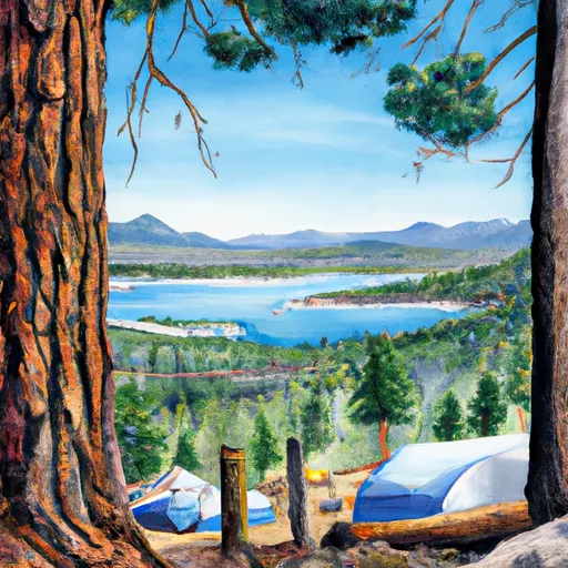
Sherrold Lake camping area is surrounded by stunning natural beauty and offers various activities for campers to enjoy. The lake itself provides opportunities for fishing, swimming, and non-motorized boating. Hiking enthusiasts can explore the nearby trails, immersing themselves in the picturesque landscapes. However, it is important to be careful of potentially hazardous wildlife encounters and to follow all safety guidelines provided by the campground staff.
In summary, Sherrold Lake camping area in California offers a range of amenities, including campsites, picnic areas, toilets, and bear-proof food storage lockers. Reservations are not accepted, so it is recommended to arrive early. The best time to visit is during the summer months. Visitors can enjoy activities such as fishing, swimming, boating, and hiking. However, campers should exercise caution regarding wildlife encounters and adhere to safety guidelines.
What's on-site at Sherrold Lake
Key facilities Snoflo tracks for this campground. Confirm with the operator before booking -- amenities can change seasonally.
Plan your trip down to the hour
Same weather feed Snoflo's iOS app uses -- updated continuously from NOAA / yr.no.
Next 5 days, hour by hour
Temperature line with weather symbols on top, snow + rain accumulation as columns, humidity as a dotted line.
5-day forecast table
Every 3 hours, broken out across temperature, snow, rain, humidity, and wind. Each cell is colour-coded relative to the column min/max so trends jump out at a glance.
| Time | Condition | Temp (°F) | Snow (in) | Rain (in) | Humidity (%) | Wind (mps) | Wind dir |
|---|---|---|---|---|---|---|---|
| Loading detailed forecast… | |||||||
15-day temperature & precipitation
Daily temperatures, snow, and rain projected over the next two weeks. Hover any point for the full breakdown.
Other campgrounds in the area
Snoflo-tracked campsites within driving distance of Sherrold Lake, with reservations status.
| Campground | Reservations | Toilets | View |
|---|---|---|---|
| Bloomfield I | ✗ | ✓ | → |
| Bloomfield Campground | ✗ | ✗ | → |
| Bloomfield 2 | ✗ | ✓ | → |
| Silver Creek-Hwy 4 | ✓ | ✓ | → |
| Grouse Flat | ✗ | ✗ | → |
Nearby streamflow
USGS streamgauges within reach of Sherrold Lake -- pulled live from the National Water Information System.
| Streamgauge | Discharge | View |
|---|---|---|
| E F Carson R Bl Markleeville C Nr Markleevilleca | 77 cfs | → |
| Leviathan C Ab Mine Nr Markleeville Ca | 0 cfs | → |
| Leviathan Mine Adit Drain Nr Markleeville Ca | 0 cfs | → |
| Leviathan C Channel Underdrain Nr Markleeville Ca | 0 cfs | → |
| 4l C Nr Markleeville Ca | · | → |
| Aspen C Abv Leviathan Mine Nr Markleeville Ca | 0 cfs | → |
Nearby snow depths
NRCS SNOTEL stations within reach of Sherrold Lake -- relevant when planning a shoulder-season or alpine trip.
| SNOTEL station | Snowpack | 24h Snowfall | View |
|---|---|---|---|
| Nohrsc Ebbetts Pass | 0.0 in | 0.0 in | → |
| Ebbetts Pass | 0.0 in | 0.0 in | → |
| Blue Lakes | 2.0 in | 0.0 in | → |
| Nohrsc Blue Lakes | 1.0 in | 0.0 in | → |
| Nohrsc Elstanislaus Meadow (Goes) | 0.1 in | 0.0 in | → |
| Nohrsc Spratt Creek | 1.0 in | 0.0 in | → |
Plan a longer trip
The closest parks, lakes, boat launches, and paddle runs so a camping night can grow into a full weekend.
Parks
- Heenan Lake Wildlife Area
- Grover Hot Springs State Park
- Wildlife Area Slinkard / Little Antelope
- Wilderness Carson-Iceberg
- Wilderness Mokelumne
- Toiyabe National Forest
Boat launches
- Highland Lakes
- Lake Alpine
- Summit Lake Trail Alpine County
- Indian Creek Camp Ground Day Use Area
- Caples Lake Resort
- Amador County
Fishing spots
Points of interest
- Hermit Valley
- Hangmans Bridge
- Osborne Ridge Warming Hut
- Bjornloppet Hut
- Equipe Hut
- Columns Of The Giants
Paddle runs
- Highway 4 To Salt Springs Reservoir
- Source Sec 24, T6n, R21e To Centerville Flat
- Wilderness Boundary To Confluence With Middle Fork Stanislaus
- Headwaters To Wilderness Boundary
- Centerville Flat To Hangman's Bridge
- Headwaters In Sec 2, T9n, R18e To Confluence With Mokelumne River
Camping essentials & Leave No Trace
- Pack it in, pack it out
- Take all trash, food scraps, and gear back with you to keep campsites clean and protect wildlife.
- Respect wildlife
- Observe animals from a distance, store food securely, and never feed wildlife to maintain natural behavior and safety.
- Know before you go
- Check weather, fire restrictions, trail conditions, and permit requirements to ensure a safe and well-planned trip.
- Minimize campfire impact
- Use established fire rings, keep fires small, fully extinguish them, or opt for a camp stove when fires are restricted.
- Leave what you find
- Preserve natural and cultural features by avoiding removal of plants, rocks, artifacts, or other elements of the environment.
Set push alerts in the Snoflo app
Save Sherrold Lake as a favorite, set a custom threshold (precipitation, snowpack, freezing temperatures), and the iOS app will push the moment conditions cross.
About Sherrold Lake
Can I make reservations at Sherrold Lake?
This campground does not appear to accept reservations -- it's typically first-come, first-served. Arrive early on summer weekends.
How fresh is the weather data on this page?
The hourly forecast updates throughout the day from the NOAA / yr.no public feeds. Streamflow data is pulled live from USGS streamgauges and snowpack from the NRCS SNOTEL network.
What's the best time of year to visit?
Use the 15-day temperature & precipitation outlook on this page to plan -- pick a window with comfortable temperatures and low precipitation. For longer trips, the 5-day hourly meteogram shows snow + rain accumulation hour-by-hour.
How do I get to Sherrold Lake?
Tap Directions in the hero above to open driving directions in Google Maps, or Open in map to center the Snoflo interactive map on the campground.
Can I get alerts when conditions change?
Yes -- alerts are managed through the Snoflo iOS app. Favorite this campground, set a threshold (temperature, snowpack, precipitation), and you'll get a push the moment it crosses.
Other campgrounds near here
Snoflo-tracked campgrounds within driving distance of Sherrold Lake.