Upper Rush Creek Campground
Community Reviews
Been here? Share the conditions.
Reviews, ratings & photos are added in the free Snoflo iOS app — rate a spot, tag the conditions, and your visit is verified by location. Add or manage your reviews from the app.
Upper Rush Creek
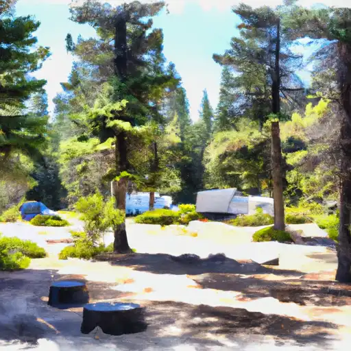
The campground has 17 campsites available on a first-come-first-serve basis, with amenities including picnic tables, fire pits, and vault toilets. The area is known for its rustic charm and peaceful atmosphere, perfect for those seeking a quiet escape in the outdoors.
An interesting fact about the area is its history as a former logging town, with many of the trees in the surrounding forests being replanted in the 1900s. This rich history adds to the unique charm of the campground and surrounding area.
The best time to visit Upper Rush Creek Camping Area is during the summer months, with average temperatures ranging from the mid-70s to low 80s Fahrenheit. However, visitors should be prepared for cooler temperatures at night. Overall, Upper Rush Creek Camping Area is a great destination for nature lovers seeking a peaceful escape in a beautiful natural setting.
What's on-site at Upper Rush Creek
Key facilities Snoflo tracks for this campground. Confirm with the operator before booking -- amenities can change seasonally.
Plan your trip down to the hour
Same weather feed Snoflo's iOS app uses -- updated continuously from NOAA / yr.no.
Next 5 days, hour by hour
Temperature line with weather symbols on top, snow + rain accumulation as columns, humidity as a dotted line.
5-day forecast table
Every 3 hours, broken out across temperature, snow, rain, humidity, and wind. Each cell is colour-coded relative to the column min/max so trends jump out at a glance.
| Time | Condition | Temp (°F) | Snow (in) | Rain (in) | Humidity (%) | Wind (mps) | Wind dir |
|---|---|---|---|---|---|---|---|
| Loading detailed forecast… | |||||||
15-day temperature & precipitation
Daily temperatures, snow, and rain projected over the next two weeks. Hover any point for the full breakdown.
Other campgrounds in the area
Snoflo-tracked campsites within driving distance of Upper Rush Creek, with reservations status.
| Campground | Reservations | Toilets | View |
|---|---|---|---|
| Lower Rush Creek Campground | ✓ | ✗ | → |
| Lower Rush Creek | ✗ | ✓ | → |
| Red Tail Rim South | ✗ | ✓ | → |
| Red Tail Rim Trail South Trailhead | ✓ | ✗ | → |
| Red Tail Rim Trail South Trailhead/Campground | ✗ | ✗ | → |
Nearby streamflow
USGS streamgauges within reach of Upper Rush Creek -- pulled live from the National Water Information System.
| Streamgauge | Discharge | View |
|---|---|---|
| Pit R Nr Canby Ca | 2 cfs | → |
| Sf Pit R Nr Likely Ca | 108 cfs | → |
| Pit R Bl Pit No 1 Ph Nr Fall River Mills Ca | 1,200 cfs | → |
| Burney C A Burney Falls Nr Burney Ca | 168 cfs | → |
| Hat C Nr Hat Creek Ca | 123 cfs | → |
Nearby snow depths
NRCS SNOTEL stations within reach of Upper Rush Creek -- relevant when planning a shoulder-season or alpine trip.
| SNOTEL station | Snowpack | 24h Snowfall | View |
|---|---|---|---|
| Adin Mtn | 2.0 in | 0.0 in | → |
| Nohrsc Adin Mtn | 2.0 in | 0.0 in | → |
| Juniper Creek | 4.8 in | 0.0 in | → |
| Alturas 9.5 E | 0.0 in | 0.0 in | → |
| Blue Door Goes | 0.0 in | 0.0 in | → |
| Nohrsc Cedar Pass | 1.0 in | 0.0 in | → |
Plan a longer trip
The closest parks, lakes, boat launches, and paddle runs so a camping night can grow into a full weekend.
Parks
- Modoc National Wildlife Refuge
- Ash Creek Wildlife Area
- Ahjumawi Lava Springs State Park
- South Warner Wilderness
Boat launches
- Duncan South Boating Site
- Duncan North Boating Site
- Big Sage Road Modoc County
- West Valley Reservoir Fishing Access
- Logan Slough Boating Site
Fishing spots
Paddle runs
- Begins Near Muck Valley To Ends Two Miles From The Fall River Valley
- Upper Pit River Canyon
- Sally's Camp To Confluence With Willow Creek
- Begins 2.5 Miles West Of Little Valley, California To Juncture With The Pit River.
- Lower Horse Creek Canyon
- Begins Immediately Southwest Of Fall River Mills, Ca To It Flows Into Shasta Lake And The Sacramento River.
Camping essentials & Leave No Trace
- Pack it in, pack it out
- Take all trash, food scraps, and gear back with you to keep campsites clean and protect wildlife.
- Respect wildlife
- Observe animals from a distance, store food securely, and never feed wildlife to maintain natural behavior and safety.
- Know before you go
- Check weather, fire restrictions, trail conditions, and permit requirements to ensure a safe and well-planned trip.
- Minimize campfire impact
- Use established fire rings, keep fires small, fully extinguish them, or opt for a camp stove when fires are restricted.
- Leave what you find
- Preserve natural and cultural features by avoiding removal of plants, rocks, artifacts, or other elements of the environment.
Set push alerts in the Snoflo app
Save Upper Rush Creek as a favorite, set a custom threshold (precipitation, snowpack, freezing temperatures), and the iOS app will push the moment conditions cross.
About Upper Rush Creek
Can I make reservations at Upper Rush Creek?
This campground does not appear to accept reservations -- it's typically first-come, first-served. Arrive early on summer weekends.
How fresh is the weather data on this page?
The hourly forecast updates throughout the day from the NOAA / yr.no public feeds. Streamflow data is pulled live from USGS streamgauges and snowpack from the NRCS SNOTEL network.
What's the best time of year to visit?
Use the 15-day temperature & precipitation outlook on this page to plan -- pick a window with comfortable temperatures and low precipitation. For longer trips, the 5-day hourly meteogram shows snow + rain accumulation hour-by-hour.
How do I get to Upper Rush Creek?
Tap Directions in the hero above to open driving directions in Google Maps, or Open in map to center the Snoflo interactive map on the campground.
Can I get alerts when conditions change?
Yes -- alerts are managed through the Snoflo iOS app. Favorite this campground, set a threshold (temperature, snowpack, precipitation), and you'll get a push the moment it crosses.
Other campgrounds near here
Snoflo-tracked campgrounds within driving distance of Upper Rush Creek.