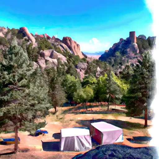
Devils Head Campground
Community Reviews
Been here? Share the conditions.
Reviews, ratings & photos are added in the free Snoflo iOS app — rate a spot, tag the conditions, and your visit is verified by location. Add or manage your reviews from the app.
Devils Head
Reservations are not accepted at Devils Head camping area, as it operates on a first-come, first-served basis. This allows campers the flexibility to plan their trips without the hassle of pre-booking. The best time to visit the campground is during the summer months, from June to September, when the weather is mild and favorable for outdoor activities. However, it's crucial to be prepared for sudden weather changes and heavy rainfall, as the area is prone to thunderstorms.
While exploring the camping area, visitors should make sure not to miss the Devils Head Lookout Trail, which leads to a historic fire lookout tower offering breathtaking panoramic views of the surrounding landscape. It's important to exercise caution and be aware of wildlife, particularly bears, in the area. Campers are advised to follow proper food storage protocols and keep a safe distance from any wild animals encountered. Overall, Devils Head camping area provides an idyllic setting for nature enthusiasts to relax, explore, and appreciate the beauty of Colorado's wilderness.
What's on-site at Devils Head
Key facilities Snoflo tracks for this campground. Confirm with the operator before booking -- amenities can change seasonally.
Plan your trip down to the hour
Same weather feed Snoflo's iOS app uses -- updated continuously from NOAA / yr.no.
Next 5 days, hour by hour
Temperature line with weather symbols on top, snow + rain accumulation as columns, humidity as a dotted line.
5-day forecast table
Every 3 hours, broken out across temperature, snow, rain, humidity, and wind. Each cell is colour-coded relative to the column min/max so trends jump out at a glance.
| Time | Condition | Temp (°F) | Snow (in) | Rain (in) | Humidity (%) | Wind (mps) | Wind dir |
|---|---|---|---|---|---|---|---|
| Loading detailed forecast… | |||||||
15-day temperature & precipitation
Daily temperatures, snow, and rain projected over the next two weeks. Hover any point for the full breakdown.
Other campgrounds in the area
Snoflo-tracked campsites within driving distance of Devils Head, with reservations status.
| Campground | Reservations | Toilets | View |
|---|---|---|---|
| Devil's Head Campground | ✓ | ✗ | → |
| Jackson Creek | ✗ | ✓ | → |
| Flat Rocks | ✗ | ✓ | → |
| Platte River | ✗ | ✓ | → |
| Ouzel Campground | ✗ | ✗ | → |
Nearby streamflow
USGS streamgauges within reach of Devils Head -- pulled live from the National Water Information System.
| Streamgauge | Discharge | View |
|---|---|---|
| So. Platte R. Blw Brush Cr. Nr Trumbull Co | 235 cfs | → |
| Trout Creek Blw Fern Cr Nr Westcreek | 1 cfs | → |
| West Cr. Abv Shrewsbury Gulch Nr Westcreek Co | 1 cfs | → |
| South Platte River Below Cheesman Lake | 242 cfs | → |
| South Platte River At South Platte | 604 cfs | → |
| Plum Creek Near Sedalia | 9 cfs | → |
Nearby snow depths
NRCS SNOTEL stations within reach of Devils Head -- relevant when planning a shoulder-season or alpine trip.
| SNOTEL station | Snowpack | 24h Snowfall | View |
|---|---|---|---|
| Cheesman | 0.0 in | 0.0 in | → |
| Strontia Springs Dam | 0.0 in | 0.0 in | → |
| Castle Rock 1.7 Ssw | 0.0 in | 0.0 in | → |
| Castle Rock | 0.0 in | 0.0 in | → |
| Palmer Lake | 0.0 in | 0.0 in | → |
| Palmer Lake 0.3 W | 0.0 in | 0.0 in | → |
Plan a longer trip
The closest parks, lakes, boat launches, and paddle runs so a camping night can grow into a full weekend.
Parks
- Roxborough State Park
- Plum Creek
- Reynolds Ranch Open Space Park
- Douglas County Fairgrounds
- Castle Rock Ballfield
- Dupont Park
Fishing spots
- South Platte River
- Strontia Springs Reservoir
- Cheesman Reservoir
- Strortia Springs Reservoir
- Manitou Lake
- Upper Reservoir - Palmer Lake
Camping essentials & Leave No Trace
- Pack it in, pack it out
- Take all trash, food scraps, and gear back with you to keep campsites clean and protect wildlife.
- Respect wildlife
- Observe animals from a distance, store food securely, and never feed wildlife to maintain natural behavior and safety.
- Know before you go
- Check weather, fire restrictions, trail conditions, and permit requirements to ensure a safe and well-planned trip.
- Minimize campfire impact
- Use established fire rings, keep fires small, fully extinguish them, or opt for a camp stove when fires are restricted.
- Leave what you find
- Preserve natural and cultural features by avoiding removal of plants, rocks, artifacts, or other elements of the environment.
Set push alerts in the Snoflo app
Save Devils Head as a favorite, set a custom threshold (precipitation, snowpack, freezing temperatures), and the iOS app will push the moment conditions cross.
About Devils Head
Can I make reservations at Devils Head?
This campground does not appear to accept reservations -- it's typically first-come, first-served. Arrive early on summer weekends.
How fresh is the weather data on this page?
The hourly forecast updates throughout the day from the NOAA / yr.no public feeds. Streamflow data is pulled live from USGS streamgauges and snowpack from the NRCS SNOTEL network.
What's the best time of year to visit?
Use the 15-day temperature & precipitation outlook on this page to plan -- pick a window with comfortable temperatures and low precipitation. For longer trips, the 5-day hourly meteogram shows snow + rain accumulation hour-by-hour.
How do I get to Devils Head?
Tap Directions in the hero above to open driving directions in Google Maps, or Open in map to center the Snoflo interactive map on the campground.
Can I get alerts when conditions change?
Yes -- alerts are managed through the Snoflo iOS app. Favorite this campground, set a threshold (temperature, snowpack, precipitation), and you'll get a push the moment it crosses.
Other campgrounds near here
Snoflo-tracked campgrounds within driving distance of Devils Head.