Zapata Falls Site 25 Campground
Community Reviews
Been here? Share the conditions.
Reviews, ratings & photos are added in the free Snoflo iOS app — rate a spot, tag the conditions, and your visit is verified by location. Add or manage your reviews from the app.
Zapata Falls Site 25
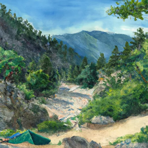
Nearby points of interest include the Great Sand Dunes National Park and Preserve, which features the tallest sand dunes in North America, as well as hiking trails and wildlife viewing opportunities. The San Luis Valley is also home to several hot springs and the historic town of San Luis, the oldest continuously inhabited town in Colorado.
The Zapata Falls Site 25 Campsite offers amenities such as picnic tables, fire rings, and vault toilets. There is no potable water available, so visitors should bring their own or treat water from the nearby creek.
Interesting facts about the area include the fact that the Great Sand Dunes were formed by sand from the ancient Rio Grande that was carried and deposited by winds and water. Additionally, the Sangre de Cristo Mountains are named for the Spanish phrase meaning "Blood of Christ," due to the red color of the mountains at sunrise and sunset.
The best time of year to visit the Zapata Falls Site 25 Campsite is during the summer months when temperatures are mild and the campsite is open. Average temperatures during this time range from the mid-70s to low 80s during the day and the mid-40s to low 50s at night.
What's on-site at Zapata Falls Site 25
Key facilities Snoflo tracks for this campground. Confirm with the operator before booking -- amenities can change seasonally.
Plan your trip down to the hour
Same weather feed Snoflo's iOS app uses -- updated continuously from NOAA / yr.no.
Next 5 days, hour by hour
Temperature line with weather symbols on top, snow + rain accumulation as columns, humidity as a dotted line.
5-day forecast table
Every 3 hours, broken out across temperature, snow, rain, humidity, and wind. Each cell is colour-coded relative to the column min/max so trends jump out at a glance.
| Time | Condition | Temp (°F) | Snow (in) | Rain (in) | Humidity (%) | Wind (mps) | Wind dir |
|---|---|---|---|---|---|---|---|
| Loading detailed forecast… | |||||||
15-day temperature & precipitation
Daily temperatures, snow, and rain projected over the next two weeks. Hover any point for the full breakdown.
Other campgrounds in the area
Snoflo-tracked campsites within driving distance of Zapata Falls Site 25, with reservations status.
| Campground | Reservations | Toilets | View |
|---|---|---|---|
| North Fruita Desert Upper Campground D2 | ✗ | ✗ | → |
| North Fruita Desert Upper Campground D1 | ✗ | ✗ | → |
| North Fruita Desert Upper Campground D8 | ✗ | ✗ | → |
| North Fruita Desert Upper Campground D9 | ✗ | ✗ | → |
| North Fruita Desert Upper Campground D7 | ✗ | ✗ | → |
| North Fruita Desert Upper Campground-D6 | ✗ | ✗ | → |
Nearby streamflow
USGS streamgauges within reach of Zapata Falls Site 25 -- pulled live from the National Water Information System.
| Streamgauge | Discharge | View |
|---|---|---|
| Colorado River Near Colorado-Utah State Line | 2,020 cfs | → |
| Colorado River Near Cameo | 1,630 cfs | → |
| Colo River Blw Grd Valley Div Nr Palisade Co | 310 cfs | → |
| Plateau Creek Near Cameo | 15 cfs | → |
| Gunnison River Near Grand Junction | 641 cfs | → |
| Corral Gulch Near Rangely | 1 cfs | → |
Nearby snow depths
NRCS SNOTEL stations within reach of Zapata Falls Site 25 -- relevant when planning a shoulder-season or alpine trip.
| SNOTEL station | Snowpack | 24h Snowfall | View |
|---|---|---|---|
| Great Sand Dunes Natl Mon | 0.0 in | 0.0 in | → |
| Nohrsc Ute Creek | 0.0 in | 0.0 in | → |
| Ute Creek | 0.0 in | 0.0 in | → |
| Nohrsc Medano Pass | 0.0 in | 0.0 in | → |
| Medano Pass | 1.0 in | 0.0 in | → |
| Alamosa 1.1 N | 0.0 in | 0.0 in | → |
Plan a longer trip
The closest parks, lakes, boat launches, and paddle runs so a camping night can grow into a full weekend.
Parks
- Wilderness Sangre De Cristo
- National Park Great Sand Dunes
- Great Sand Dunes National Park And Preserve
- Wilderness Great Sand Dunes
- San Luis State Park
- San Luis Lakes Wildlife Area
Boat launches
- Highline Lake State Park
- 12 1/2 Rd Mesa County
- Loma Boat Launch
- James M. Robb - Colorado River State Park
Fishing spots
- San Luis Lake
- Manzanares Creek
- Smith Reservoir (Costilla Cty)
- Mountain Home Reservoir
- Conejos River
- Rio Grande Swa
Camping essentials & Leave No Trace
- Pack it in, pack it out
- Take all trash, food scraps, and gear back with you to keep campsites clean and protect wildlife.
- Respect wildlife
- Observe animals from a distance, store food securely, and never feed wildlife to maintain natural behavior and safety.
- Know before you go
- Check weather, fire restrictions, trail conditions, and permit requirements to ensure a safe and well-planned trip.
- Minimize campfire impact
- Use established fire rings, keep fires small, fully extinguish them, or opt for a camp stove when fires are restricted.
- Leave what you find
- Preserve natural and cultural features by avoiding removal of plants, rocks, artifacts, or other elements of the environment.
Set push alerts in the Snoflo app
Save Zapata Falls Site 25 as a favorite, set a custom threshold (precipitation, snowpack, freezing temperatures), and the iOS app will push the moment conditions cross.
About Zapata Falls Site 25
Can I make reservations at Zapata Falls Site 25?
This campground does not appear to accept reservations -- it's typically first-come, first-served. Arrive early on summer weekends.
How fresh is the weather data on this page?
The hourly forecast updates throughout the day from the NOAA / yr.no public feeds. Streamflow data is pulled live from USGS streamgauges and snowpack from the NRCS SNOTEL network.
What's the best time of year to visit?
Use the 15-day temperature & precipitation outlook on this page to plan -- pick a window with comfortable temperatures and low precipitation. For longer trips, the 5-day hourly meteogram shows snow + rain accumulation hour-by-hour.
How do I get to Zapata Falls Site 25?
Tap Directions in the hero above to open driving directions in Google Maps, or Open in map to center the Snoflo interactive map on the campground.
Can I get alerts when conditions change?
Yes -- alerts are managed through the Snoflo iOS app. Favorite this campground, set a threshold (temperature, snowpack, precipitation), and you'll get a push the moment it crosses.
Other campgrounds near here
Snoflo-tracked campgrounds within driving distance of Zapata Falls Site 25.