Twin Poles Campground
Community Reviews
Been here? Share the conditions.
Reviews, ratings & photos are added in the free Snoflo iOS app — rate a spot, tag the conditions, and your visit is verified by location. Add or manage your reviews from the app.
Twin Poles
There are plenty of nearby points of interest for visitors to explore, including the Juniper Springs Recreation Area, the Alexander Springs Recreation Area, and the Salt Springs Recreation Area. Each of these locations offers hiking trails, swimming opportunities, and other outdoor activities for visitors to enjoy.
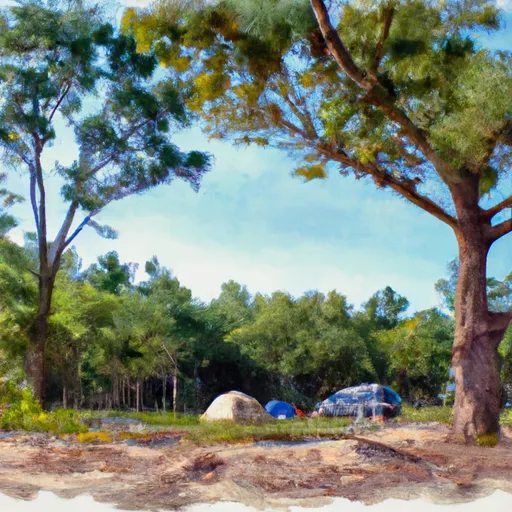
The Twin Poles Camping Area offers a range of amenities for campers, including picnic tables, fire rings, and grills. The campground is first-come-first-serve, so visitors are encouraged to arrive early to secure a spot. There are a total of 13 campsites available, each with access to potable water and a restroom facility.
An interesting fact about the area is that it is home to some of the oldest sand pine trees in the state of Florida, with some estimated to be over 300 years old.
The best time of year to visit Twin Poles Camping Area is during the spring and fall months, with average temperatures ranging from the mid-70s to the low 80s. Summers can be hot and humid, with temperatures reaching into the high 90s, while winters can be mild, with average temperatures in the low 60s. Overall, the Twin Poles Camping Area offers visitors a unique camping experience surrounded by the natural beauty of the Ocala National Forest.
What's on-site at Twin Poles
Key facilities Snoflo tracks for this campground. Confirm with the operator before booking -- amenities can change seasonally.
Plan your trip down to the hour
Same weather feed Snoflo's iOS app uses -- updated continuously from NOAA / yr.no.
Next 5 days, hour by hour
Temperature line with weather symbols on top, snow + rain accumulation as columns, humidity as a dotted line.
5-day forecast table
Every 3 hours, broken out across temperature, snow, rain, humidity, and wind. Each cell is colour-coded relative to the column min/max so trends jump out at a glance.
| Time | Condition | Temp (°F) | Snow (in) | Rain (in) | Humidity (%) | Wind (mps) | Wind dir |
|---|---|---|---|---|---|---|---|
| Loading detailed forecast… | |||||||
15-day temperature & precipitation
Daily temperatures, snow, and rain projected over the next two weeks. Hover any point for the full breakdown.
Other campgrounds in the area
Snoflo-tracked campsites within driving distance of Twin Poles, with reservations status.
| Campground | Reservations | Toilets | View |
|---|---|---|---|
| Twin Poles Hunt Camp | ✓ | ✗ | → |
| Cliff Lake | ✗ | ✗ | → |
| Cliff Lake Hunt Camp | ✓ | ✗ | → |
| Magnolia Landing | ✗ | ✗ | → |
| Harpers Hunt Camp | ✓ | ✗ | → |
Nearby streamflow
USGS streamgauges within reach of Twin Poles -- pulled live from the National Water Information System.
| Streamgauge | Discharge | View |
|---|---|---|
| New River Nr Sumatra Fla | 237 cfs | → |
| Ochlockonee River Nr Smith Creek | 831 cfs | → |
| Apalachicola River Nr Sumatra | 11,800 cfs | → |
| Apalachicola R.Ab Chipola Conr Wewahitchka | 10,600 cfs | → |
| Telogia Creek Nr Bristol | 85 cfs | → |
| Ochlockonee River Nr Bloxham | 783 cfs | → |
Nearby snow depths
NRCS SNOTEL stations within reach of Twin Poles -- relevant when planning a shoulder-season or alpine trip.
| SNOTEL station | Snowpack | 24h Snowfall | View |
|---|---|---|---|
| Fountain 3.4 Sse | 0.0 in | 0.0 in | → |
| Havana 4.2 Sw | 0.0 in | 0.0 in | → |
| Marianna 7 Ne | 6.0 in | 4.0 in | → |
| Lynn Haven 3.9 E | 0.0 in | 0.0 in | → |
| Havana 5.5 Ne | 0.0 in | 0.0 in | → |
| Marianna 0.8 Nne | 0.0 in | 0.0 in | → |
Plan a longer trip
The closest parks, lakes, boat launches, and paddle runs so a camping night can grow into a full weekend.
Parks
- Wilderness Mud Swamp/New River
- Lake Talquin State Forest
- Fort Gadsden Historic Site
- Apalachicola National Forest
- Apalachicola Wildlife Management Area
- Wilderness Bradwell Bay
Boat launches
- Tate's Hell State Forest - Sumatra Primitive Boat Launch
- Sheep Island Pond Primitive Access
- Camel Lake Recreation Area - Apalachicola National Forest
- Big Gully Landing And Campground
- Black Creek Boat Ramp At Wright Lake Recreation Area
- Jack Langston's Fish Camp
Fishing spots
Points of interest
- Mud Swamp/New River Wilderness
- Bradwell Bay Wilderness
- Crooked River Lighthouse
- Clear Lake Wilderness Study Area
- Orman House
- Bert Lindsley Studio-Gallery
Paddle runs
- Segment B--Sh 65 To Carr Bridge On Fh 13
- Segment C--Mud Swamp/New River Wilderness Boundary To Mud Swamp/New River Wilderness (Southern) Boundary
- 2 Miles Below Dam On Lake Talquin To Ochlockonee Bay
- Headwaters To Concrete Bridge (Burnt Bridge) On Fh 13 (Where River Enters Bradwell Ray Wilderness)
- Segment D--Mud Swamp/New River Wilderness (Southern) Wilderness Boundary To Northern Boundary Of Town Of Carrabelle (Rm 4)
- Bradwell Bay Wilderness (Northern Boundary) To Bradwell Bay Wilderness Boundary At Trice Bridge On Fr 329
Camping essentials & Leave No Trace
- Pack it in, pack it out
- Take all trash, food scraps, and gear back with you to keep campsites clean and protect wildlife.
- Respect wildlife
- Observe animals from a distance, store food securely, and never feed wildlife to maintain natural behavior and safety.
- Know before you go
- Check weather, fire restrictions, trail conditions, and permit requirements to ensure a safe and well-planned trip.
- Minimize campfire impact
- Use established fire rings, keep fires small, fully extinguish them, or opt for a camp stove when fires are restricted.
- Leave what you find
- Preserve natural and cultural features by avoiding removal of plants, rocks, artifacts, or other elements of the environment.
Set push alerts in the Snoflo app
Save Twin Poles as a favorite, set a custom threshold (precipitation, snowpack, freezing temperatures), and the iOS app will push the moment conditions cross.
About Twin Poles
Can I make reservations at Twin Poles?
This campground does not appear to accept reservations -- it's typically first-come, first-served. Arrive early on summer weekends.
How fresh is the weather data on this page?
The hourly forecast updates throughout the day from the NOAA / yr.no public feeds. Streamflow data is pulled live from USGS streamgauges and snowpack from the NRCS SNOTEL network.
What's the best time of year to visit?
Use the 15-day temperature & precipitation outlook on this page to plan -- pick a window with comfortable temperatures and low precipitation. For longer trips, the 5-day hourly meteogram shows snow + rain accumulation hour-by-hour.
How do I get to Twin Poles?
Tap Directions in the hero above to open driving directions in Google Maps, or Open in map to center the Snoflo interactive map on the campground.
Can I get alerts when conditions change?
Yes -- alerts are managed through the Snoflo iOS app. Favorite this campground, set a threshold (temperature, snowpack, precipitation), and you'll get a push the moment it crosses.
Other campgrounds near here
Snoflo-tracked campgrounds within driving distance of Twin Poles.