The Pocket Recreation Area campground
Community Reviews
Been here? Share the conditions.
Reviews, ratings & photos are added in the free Snoflo iOS app — rate a spot, tag the conditions, and your visit is verified by location. Add or manage your reviews from the app.
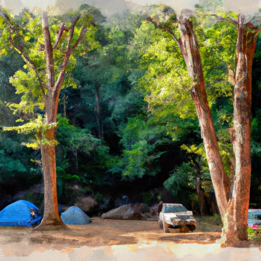
The Pocket Recreation Area
Reservations are accepted at The Pocket Recreation Area campground, allowing campers to secure their spot in advance. This is especially recommended during peak seasons, as the campground tends to get busy. The best time to visit is during the spring and fall seasons when the temperatures are mild, making it perfect for outdoor activities and enjoying the breathtaking foliage. It's important to note that the campground is closed during the winter season.
While camping at The Pocket Recreation Area, campers should be cautious of wildlife encounters, especially with black bears. It is crucial to store food properly and maintain a safe distance from any wildlife encountered to ensure a safe and enjoyable experience. Furthermore, campers should be mindful of the rules and regulations regarding campfire safety, as the campground is situated in a forested area.
In summary, The Pocket Recreation Area campground in Georgia offers a range of amenities, accepts reservations, and is best visited during the spring and fall seasons. Campers should be cautious of wildlife encounters and adhere to campfire safety regulations. Plan your adventure well in advance to make the most of this scenic camping area in the Chattahoochee National Forest.
What's on-site at The Pocket Recreation Area
Key facilities Snoflo tracks for this campground. Confirm with the operator before booking -- amenities can change seasonally.
Plan your trip down to the hour
Same weather feed Snoflo's iOS app uses -- updated continuously from NOAA / yr.no.
Next 5 days, hour by hour
Temperature line with weather symbols on top, snow + rain accumulation as columns, humidity as a dotted line.
5-day forecast table
Every 3 hours, broken out across temperature, snow, rain, humidity, and wind. Each cell is colour-coded relative to the column min/max so trends jump out at a glance.
| Time | Condition | Temp (°F) | Snow (in) | Rain (in) | Humidity (%) | Wind (mps) | Wind dir |
|---|---|---|---|---|---|---|---|
| Loading detailed forecast… | |||||||
15-day temperature & precipitation
Daily temperatures, snow, and rain projected over the next two weeks. Hover any point for the full breakdown.
Other campgrounds in the area
Snoflo-tracked campsites within driving distance of The Pocket Recreation Area, with reservations status.
| Campground | Reservations | Toilets | View |
|---|---|---|---|
| ✗ | ✗ | → | |
| James H Sloppy Floyd State Park | ✓ | ✗ | → |
| James H. Floyd State Park Campground | ✗ | ✗ | → |
| Salacoa Creek Park | ✗ | ✗ | → |
| Backcountry Campsite 3 | ✗ | ✗ | → |
Nearby streamflow
USGS streamgauges within reach of The Pocket Recreation Area -- pulled live from the National Water Information System.
| Streamgauge | Discharge | View |
|---|---|---|
| Oostanaula River At Resaca | 725 cfs | → |
| Conasauga River At Tilton | 434 cfs | → |
| Coosawattee River Near Pine Chapel | 544 cfs | → |
| Mill Creek At Dalton | 17 cfs | → |
| Chattooga River At Summerville | 112 cfs | → |
| Heath Creek Near Armuchee | 3 cfs | → |
Plan a longer trip
The closest parks, lakes, boat launches, and paddle runs so a camping night can grow into a full weekend.
Parks
- John's Mountain Wildlife Management Area
- Calhoun Rec Park
- New Echota Historic Site
- Al Rollins Baseball Complex
- Trion Field
- Lafayette Parks & Recreation
Boat launches
Fishing spots
Points of interest
- Battle Of Resaca
- New Echota State Historic Site
- Howard Finster's Paradise Garden
- Chief Vann House
- Chief Vann House State Historic Site
- Chieftains Museum
Paddle runs
- River Miles 8 Near Ga Sate Line To Confluence With Little River
- Desoto Falls In Desoto State Park To Confluence With Little River
- Confluence With East And West Branches To Al 37 Bridge
- Al 35 Bridge To Ends One Mile Upstream From Al 273 Bridge
- Source In Cohutta Wilderness To Nf Boundary North Of Murray's Lake
- Taylors Creek (Rm 74.5) To Nf Boundary (Rm 70.0)
Camping essentials & Leave No Trace
- Pack it in, pack it out
- Take all trash, food scraps, and gear back with you to keep campsites clean and protect wildlife.
- Respect wildlife
- Observe animals from a distance, store food securely, and never feed wildlife to maintain natural behavior and safety.
- Know before you go
- Check weather, fire restrictions, trail conditions, and permit requirements to ensure a safe and well-planned trip.
- Minimize campfire impact
- Use established fire rings, keep fires small, fully extinguish them, or opt for a camp stove when fires are restricted.
- Leave what you find
- Preserve natural and cultural features by avoiding removal of plants, rocks, artifacts, or other elements of the environment.
Set push alerts in the Snoflo app
Save The Pocket Recreation Area as a favorite, set a custom threshold (precipitation, snowpack, freezing temperatures), and the iOS app will push the moment conditions cross.
About The Pocket Recreation Area
Can I make reservations at The Pocket Recreation Area?
Yes -- this campground accepts reservations. Snoflo recommends booking early for peak season; check the operator (Recreation.gov / state park system / private operator) for the booking window and cancellation policy.
How fresh is the weather data on this page?
The hourly forecast updates throughout the day from the NOAA / yr.no public feeds. Streamflow data is pulled live from USGS streamgauges and snowpack from the NRCS SNOTEL network.
What's the best time of year to visit?
Use the 15-day temperature & precipitation outlook on this page to plan -- pick a window with comfortable temperatures and low precipitation. For longer trips, the 5-day hourly meteogram shows snow + rain accumulation hour-by-hour.
How do I get to The Pocket Recreation Area?
Tap Directions in the hero above to open driving directions in Google Maps, or Open in map to center the Snoflo interactive map on the campground.
Can I get alerts when conditions change?
Yes -- alerts are managed through the Snoflo iOS app. Favorite this campground, set a threshold (temperature, snowpack, precipitation), and you'll get a push the moment it crosses.
Other campgrounds near here
Snoflo-tracked campgrounds within driving distance of The Pocket Recreation Area.