Victoria Bryant State Park Campground
Community Reviews
Been here? Share the conditions.
Reviews, ratings & photos are added in the free Snoflo iOS app — rate a spot, tag the conditions, and your visit is verified by location. Add or manage your reviews from the app.
Victoria Bryant State Park
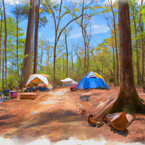
The camping area is equipped with 28 campsites, including 10 tent-only sites, and 18 RV sites with water and electric hookups. The campground amenities include picnic tables, fire rings, and grills. There are also two bathhouses with hot showers and flush toilets for guests' comfort.
Nearby points of interest include the historic town of Hartwell, the Hartwell Dam, and Lake Hartwell, which is a popular spot for boating, fishing, and swimming. Additionally, visitors can enjoy hiking, fishing, and wildlife observation at Victoria Bryant State Park.
The camping area operates on a first-come, first-served basis, so campers are encouraged to arrive early to secure their preferred site. Interestingly, the park is named after Victoria Bryant, a well-known local resident and teacher who donated the land to the state for the park's creation.
The best time of year to visit Victoria Bryant State Park is during the fall season, from September to November. During this time, the average temperature ranges from 50 to 70 degrees Fahrenheit, making it ideal for camping, hiking, and outdoor activities.
What's on-site at Victoria Bryant State Park
Key facilities Snoflo tracks for this campground. Confirm with the operator before booking -- amenities can change seasonally.
Plan your trip down to the hour
Same weather feed Snoflo's iOS app uses -- updated continuously from NOAA / yr.no.
Next 5 days, hour by hour
Temperature line with weather symbols on top, snow + rain accumulation as columns, humidity as a dotted line.
5-day forecast table
Every 3 hours, broken out across temperature, snow, rain, humidity, and wind. Each cell is colour-coded relative to the column min/max so trends jump out at a glance.
| Time | Condition | Temp (°F) | Snow (in) | Rain (in) | Humidity (%) | Wind (mps) | Wind dir |
|---|---|---|---|---|---|---|---|
| Loading detailed forecast… | |||||||
15-day temperature & precipitation
Daily temperatures, snow, and rain projected over the next two weeks. Hover any point for the full breakdown.
Other campgrounds in the area
Snoflo-tracked campsites within driving distance of Victoria Bryant State Park, with reservations status.
| Campground | Reservations | Toilets | View |
|---|---|---|---|
| River's Edge Campground | ✗ | ✗ | → |
| Tugaloo State Park | ✓ | ✗ | → |
| Hart State Park | ✗ | ✗ | → |
| Lake Hartwell State Park | ✓ | ✗ | → |
| Watsadlers | ✓ | ✗ | → |
Nearby streamflow
USGS streamgauges within reach of Victoria Bryant State Park -- pulled live from the National Water Information System.
| Streamgauge | Discharge | View |
|---|---|---|
| Beaverdam Creek Ab Elberton Ga | 27 cfs | → |
| Broad River Above Carlton | 320 cfs | → |
| South Fork Broad River At Carlton | 87 cfs | → |
| North Oconee River At College St | 79 cfs | → |
| Middle Oconee River Near Athens | 184 cfs | → |
| Middle Oconee River Near Arcade | 155 cfs | → |
Nearby snow depths
NRCS SNOTEL stations within reach of Victoria Bryant State Park -- relevant when planning a shoulder-season or alpine trip.
| SNOTEL station | Snowpack | 24h Snowfall | View |
|---|---|---|---|
| Carnesville 7.3 Sw | 0.0 in | 0.0 in | → |
| Anderson | 0.0 in | 0.0 in | → |
| Antreville | 0.0 in | 0.0 in | → |
| Sautee 3.5 Sw | 0.0 in | 0.0 in | → |
| Germany Valley | 0.0 in | 0.0 in | → |
| Dillard 0.7 Nnw | 0.0 in | 0.0 in | → |
Plan a longer trip
The closest parks, lakes, boat launches, and paddle runs so a camping night can grow into a full weekend.
Parks
- Victoria Bryan State Park
- Sammy A Haggard Park
- Tugaloo State Park
- Hart State Outdoor Recreation Area
- Watson Mill Bridge State Park
- Sadlers Creek State Park
Boat launches
- Cleveland Access
- Rocky Ford
- Rock Springs
- Harbor Light Marina
- Hartwell Marina (West)
- Tugaloo Point Franklin County
Fishing spots
Points of interest
Paddle runs
- Confluence Of Brasstown Creek And Little Brasstown Creek Just South Of Brasstown Falls Road (Fs 751) To Confluence Of Mill Branch, Brasstown Creek And Boatwright Creek Near Boatwright Road (Fs 753)
- Confluence Of Cedar Creek To 1/4 Mile Below The Nf Boundary And Fh 110, Cobbs Bridge Road
- South Of Cedar Creek Rifle Range To Confluence With Chauga River
- 1/4 Mile Below Fs 745 And Cassidy Bridge Hunt Camp To Confluence Of Cedar Creek
- Crpssing Of Land Bridge Road, Sc 196 To 1/4 Mile Below Fs 745 And Cassidy Bridge Hunt Camp
- Earl's Ford To Route 76 (Section 3)
Camping essentials & Leave No Trace
- Pack it in, pack it out
- Take all trash, food scraps, and gear back with you to keep campsites clean and protect wildlife.
- Respect wildlife
- Observe animals from a distance, store food securely, and never feed wildlife to maintain natural behavior and safety.
- Know before you go
- Check weather, fire restrictions, trail conditions, and permit requirements to ensure a safe and well-planned trip.
- Minimize campfire impact
- Use established fire rings, keep fires small, fully extinguish them, or opt for a camp stove when fires are restricted.
- Leave what you find
- Preserve natural and cultural features by avoiding removal of plants, rocks, artifacts, or other elements of the environment.
Set push alerts in the Snoflo app
Save Victoria Bryant State Park as a favorite, set a custom threshold (precipitation, snowpack, freezing temperatures), and the iOS app will push the moment conditions cross.
About Victoria Bryant State Park
Can I make reservations at Victoria Bryant State Park?
Yes -- this campground accepts reservations. Snoflo recommends booking early for peak season; check the operator (Recreation.gov / state park system / private operator) for the booking window and cancellation policy.
How fresh is the weather data on this page?
The hourly forecast updates throughout the day from the NOAA / yr.no public feeds. Streamflow data is pulled live from USGS streamgauges and snowpack from the NRCS SNOTEL network.
What's the best time of year to visit?
Use the 15-day temperature & precipitation outlook on this page to plan -- pick a window with comfortable temperatures and low precipitation. For longer trips, the 5-day hourly meteogram shows snow + rain accumulation hour-by-hour.
How do I get to Victoria Bryant State Park?
Tap Directions in the hero above to open driving directions in Google Maps, or Open in map to center the Snoflo interactive map on the campground.
Can I get alerts when conditions change?
Yes -- alerts are managed through the Snoflo iOS app. Favorite this campground, set a threshold (temperature, snowpack, precipitation), and you'll get a push the moment it crosses.
Other campgrounds near here
Snoflo-tracked campgrounds within driving distance of Victoria Bryant State Park.