Dry Fork Campground
Community Reviews
Been here? Share the conditions.
Reviews, ratings & photos are added in the free Snoflo iOS app — rate a spot, tag the conditions, and your visit is verified by location. Add or manage your reviews from the app.
Dry Fork
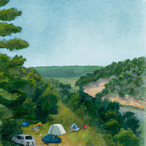
Reservations are not accepted at Dry Fork camping area, and campsites are available on a first-come, first-served basis. This adds to the spontaneity and adventure of the camping experience, allowing visitors to have the freedom to choose their preferred spot upon arrival.
The best time of year to visit Dry Fork camping area is during the spring and fall seasons when the weather is mild and pleasant. These seasons offer comfortable temperatures for outdoor activities such as hiking, fishing, and wildlife viewing. It is important to note that Missouri experiences hot and humid summers, so visiting during this time may not be as enjoyable for some campers.
While exploring the Dry Fork camping area, campers should be cautious of their surroundings and be mindful of potential wildlife encounters. It is advisable to store food in sealed containers to prevent attracting animals, and campers should also be aware of their surroundings while hiking to avoid any potential hazards. Overall, Dry Fork camping area offers a tranquil retreat for nature lovers, allowing them to immerse themselves in the beauty of Missouri's natural landscape.
What's on-site at Dry Fork
Key facilities Snoflo tracks for this campground. Confirm with the operator before booking -- amenities can change seasonally.
Plan your trip down to the hour
Same weather feed Snoflo's iOS app uses -- updated continuously from NOAA / yr.no.
Next 5 days, hour by hour
Temperature line with weather symbols on top, snow + rain accumulation as columns, humidity as a dotted line.
5-day forecast table
Every 3 hours, broken out across temperature, snow, rain, humidity, and wind. Each cell is colour-coded relative to the column min/max so trends jump out at a glance.
| Time | Condition | Temp (°F) | Snow (in) | Rain (in) | Humidity (%) | Wind (mps) | Wind dir |
|---|---|---|---|---|---|---|---|
| Loading detailed forecast… | |||||||
15-day temperature & precipitation
Daily temperatures, snow, and rain projected over the next two weeks. Hover any point for the full breakdown.
Other campgrounds in the area
Snoflo-tracked campsites within driving distance of Dry Fork, with reservations status.
| Campground | Reservations | Toilets | View |
|---|---|---|---|
| Dry Fork Recreation Area | ✗ | ✗ | → |
| Dry Fork Campground | ✗ | ✗ | → |
| Pine Ridge Campground | ✗ | ✗ | → |
| Pine Ridge | ✗ | ✗ | → |
| Pine Ridge Recreation Area | ✓ | ✗ | → |
Nearby streamflow
USGS streamgauges within reach of Dry Fork -- pulled live from the National Water Information System.
| Streamgauge | Discharge | View |
|---|---|---|
| Missouri River At Jefferson City | 48,200 cfs | → |
| Hinkson Creek At Columbia | 5 cfs | → |
| Moreau River Near Jefferson City | 44 cfs | → |
| Maries River At Westphalia | 54 cfs | → |
| Osage River Below St. Thomas | 4,290 cfs | → |
| Gasconade River Near Rich Fountain | 1,230 cfs | → |
Nearby snow depths
NRCS SNOTEL stations within reach of Dry Fork -- relevant when planning a shoulder-season or alpine trip.
| SNOTEL station | Snowpack | 24h Snowfall | View |
|---|---|---|---|
| Columbia Regional Airport | 0.0 in | 0.0 in | → |
| Boonville 4sw | 0.0 in | 0.0 in | → |
| Iberia | 0.0 in | 0.0 in | → |
Plan a longer trip
The closest parks, lakes, boat launches, and paddle runs so a camping night can grow into a full weekend.
Parks
- Cedar Valley Riders Saddle Club Arena
- Charles W. Green Conservation Area
- Maude Hall Jones Roadside Park
- Ashland Community
- Little Dixie Lake Conservation Area
- Three Creeks Conservation Area
Camping essentials & Leave No Trace
- Pack it in, pack it out
- Take all trash, food scraps, and gear back with you to keep campsites clean and protect wildlife.
- Respect wildlife
- Observe animals from a distance, store food securely, and never feed wildlife to maintain natural behavior and safety.
- Know before you go
- Check weather, fire restrictions, trail conditions, and permit requirements to ensure a safe and well-planned trip.
- Minimize campfire impact
- Use established fire rings, keep fires small, fully extinguish them, or opt for a camp stove when fires are restricted.
- Leave what you find
- Preserve natural and cultural features by avoiding removal of plants, rocks, artifacts, or other elements of the environment.
Set push alerts in the Snoflo app
Save Dry Fork as a favorite, set a custom threshold (precipitation, snowpack, freezing temperatures), and the iOS app will push the moment conditions cross.
About Dry Fork
Can I make reservations at Dry Fork?
This campground does not appear to accept reservations -- it's typically first-come, first-served. Arrive early on summer weekends.
How fresh is the weather data on this page?
The hourly forecast updates throughout the day from the NOAA / yr.no public feeds. Streamflow data is pulled live from USGS streamgauges and snowpack from the NRCS SNOTEL network.
What's the best time of year to visit?
Use the 15-day temperature & precipitation outlook on this page to plan -- pick a window with comfortable temperatures and low precipitation. For longer trips, the 5-day hourly meteogram shows snow + rain accumulation hour-by-hour.
How do I get to Dry Fork?
Tap Directions in the hero above to open driving directions in Google Maps, or Open in map to center the Snoflo interactive map on the campground.
Can I get alerts when conditions change?
Yes -- alerts are managed through the Snoflo iOS app. Favorite this campground, set a threshold (temperature, snowpack, precipitation), and you'll get a push the moment it crosses.
Other campgrounds near here
Snoflo-tracked campgrounds within driving distance of Dry Fork.