Washington County Lake State Conservation Area Campground
Community Reviews
Been here? Share the conditions.
Reviews, ratings & photos are added in the free Snoflo iOS app — rate a spot, tag the conditions, and your visit is verified by location. Add or manage your reviews from the app.
Washington County Lake State Conservation Area
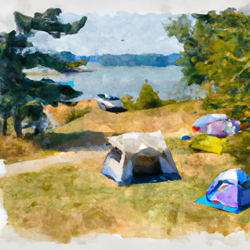
The camping area at Washington County Lake State Conservation Area is equipped with modern amenities, including restrooms, showers, and electricity. It has 29 campsites, all of which are available on a first-come, first-served basis. Visitors can also enjoy picnic areas, playgrounds, and grilling stations on-site to make their stay more comfortable.
An interesting fact about the area is that it was once home to the Kaskaskia Indians, who were known for their skills in agriculture and hunting. Today, visitors can still see remnants of their culture in the form of artifacts and burial mounds in the nearby Kaskaskia State Park.
The best time to visit the Washington County Lake State Conservation Area is during the spring and fall months when the temperatures are mild, and the colors of the surrounding forests are at their peak. The average temperature during these months is around 70°F. However, visitors should be aware that the camping area is open year-round, so they can enjoy its beauty and amenities any time of the year.
What's on-site at Washington County Lake State Conservation Area
Key facilities Snoflo tracks for this campground. Confirm with the operator before booking -- amenities can change seasonally.
Plan your trip down to the hour
Same weather feed Snoflo's iOS app uses -- updated continuously from NOAA / yr.no.
Next 5 days, hour by hour
Temperature line with weather symbols on top, snow + rain accumulation as columns, humidity as a dotted line.
5-day forecast table
Every 3 hours, broken out across temperature, snow, rain, humidity, and wind. Each cell is colour-coded relative to the column min/max so trends jump out at a glance.
| Time | Condition | Temp (°F) | Snow (in) | Rain (in) | Humidity (%) | Wind (mps) | Wind dir |
|---|---|---|---|---|---|---|---|
| Loading detailed forecast… | |||||||
15-day temperature & precipitation
Daily temperatures, snow, and rain projected over the next two weeks. Hover any point for the full breakdown.
Other campgrounds in the area
Snoflo-tracked campsites within driving distance of Washington County Lake State Conservation Area, with reservations status.
| Campground | Reservations | Toilets | View |
|---|---|---|---|
| Shady Rest | ✗ | ✗ | → |
| Lonely Oak | ✗ | ✗ | → |
| North Campground | ✗ | ✗ | → |
| Boulder Campground | ✗ | ✗ | → |
| Heron Campground | ✗ | ✗ | → |
Nearby streamflow
USGS streamgauges within reach of Washington County Lake State Conservation Area -- pulled live from the National Water Information System.
| Streamgauge | Discharge | View |
|---|---|---|
| Little Crooked Creek Near New Minden | 2 cfs | → |
| Rayse Creek Near Waltonville | 3 cfs | → |
| Kaskaskia River Near Venedy Station | 1,970 cfs | → |
| Kaskaskia River At Carlyle | 1,750 cfs | → |
| Shoal Creek Near Breese | 53 cfs | → |
| Casey Fork At Mount Vernon | 3 cfs | → |
Nearby snow depths
NRCS SNOTEL stations within reach of Washington County Lake State Conservation Area -- relevant when planning a shoulder-season or alpine trip.
| SNOTEL station | Snowpack | 24h Snowfall | View |
|---|---|---|---|
| Centralia | 0.0 in | 0.4 in | → |
| Mascoutah 1.5 Sse | 0.0 in | 0.0 in | → |
| De Soto 0.3 Ese | 0.0 in | 0.0 in | → |
| Chester | 0.0 in | 0.0 in | → |
| Kaskaskia River Navigation Lock | 0.0 in | 0.0 in | → |
Plan a longer trip
The closest parks, lakes, boat launches, and paddle runs so a camping night can grow into a full weekend.
Parks
- Washington County State Recreational Area
- Community Club Park
- Pinckneyville City Park
- Ocya Park
- Pyramid State Recreationa Area
- Schoendienst Park
Boat launches
- Washington County Lake
- Pinckneyville City Lake
- Du Quoin City Reservoir
- Pyramid State Park
- Pyramid - Redhead Lake
Camping essentials & Leave No Trace
- Pack it in, pack it out
- Take all trash, food scraps, and gear back with you to keep campsites clean and protect wildlife.
- Respect wildlife
- Observe animals from a distance, store food securely, and never feed wildlife to maintain natural behavior and safety.
- Know before you go
- Check weather, fire restrictions, trail conditions, and permit requirements to ensure a safe and well-planned trip.
- Minimize campfire impact
- Use established fire rings, keep fires small, fully extinguish them, or opt for a camp stove when fires are restricted.
- Leave what you find
- Preserve natural and cultural features by avoiding removal of plants, rocks, artifacts, or other elements of the environment.
Set push alerts in the Snoflo app
Save Washington County Lake State Conservation Area as a favorite, set a custom threshold (precipitation, snowpack, freezing temperatures), and the iOS app will push the moment conditions cross.
About Washington County Lake State Conservation Area
Can I make reservations at Washington County Lake State Conservation Area?
Yes -- this campground accepts reservations. Snoflo recommends booking early for peak season; check the operator (Recreation.gov / state park system / private operator) for the booking window and cancellation policy.
How fresh is the weather data on this page?
The hourly forecast updates throughout the day from the NOAA / yr.no public feeds. Streamflow data is pulled live from USGS streamgauges and snowpack from the NRCS SNOTEL network.
What's the best time of year to visit?
Use the 15-day temperature & precipitation outlook on this page to plan -- pick a window with comfortable temperatures and low precipitation. For longer trips, the 5-day hourly meteogram shows snow + rain accumulation hour-by-hour.
How do I get to Washington County Lake State Conservation Area?
Tap Directions in the hero above to open driving directions in Google Maps, or Open in map to center the Snoflo interactive map on the campground.
Can I get alerts when conditions change?
Yes -- alerts are managed through the Snoflo iOS app. Favorite this campground, set a threshold (temperature, snowpack, precipitation), and you'll get a push the moment it crosses.
Other campgrounds near here
Snoflo-tracked campgrounds within driving distance of Washington County Lake State Conservation Area.